
Mapa mental
Geomorphological Region.
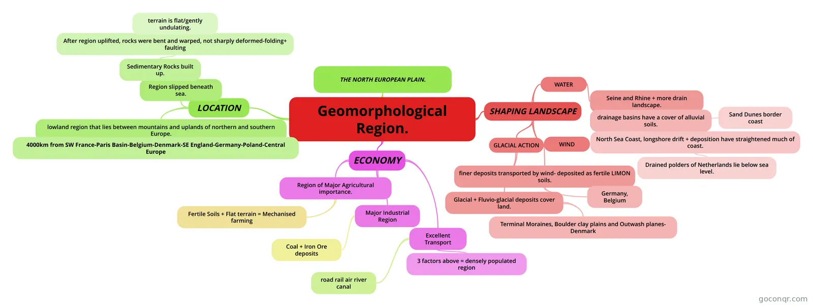
Mind map: Geomorphological region: North European Plain
Contenido del mapa
Geomorphological Region.
THE NORTH EUROPEAN PLAIN.
LOCATION
- lowland region that lies between mountains and uplands of northern and southern Europe.
- 4000km from SW France-Paris Basin-Belgium-Denmark-SE England-Germany-Poland-Central Europe
- Region slipped beneath sea.
- Sedimentary Rocks built up.
- After region uplifted, rocks were bent and warped, not sharply deformed-folding+ faulting
- terrain is flat/gently undulating.
- After region uplifted, rocks were bent and warped, not sharply deformed-folding+ faulting
- Sedimentary Rocks built up.
- lowland region that lies between mountains and uplands of northern and southern Europe.
SHAPING LANDSCAPE
- WATER
- Seine and Rhine + more drain landscape.
- drainage basins have a cover of alluvial soils.
- North Sea Coast, longshore drift + deposition have straightened much of coast.
- Sand Dunes border coast
- Drained polders of Netherlands lie below sea level.
- North Sea Coast, longshore drift + deposition have straightened much of coast.
- drainage basins have a cover of alluvial soils.
- Seine and Rhine + more drain landscape.
- WIND
- GLACIAL ACTION
- Glacial + Fluvio-glacial deposits cover land.
- Terminal Moraines, Boulder clay plains and Outwash planes- Denmark
- finer deposits transported by wind- deposited as fertile LIMON soils.
- Germany, Belgium
- Glacial + Fluvio-glacial deposits cover land.
- WATER
ECONOMY
- Region of Major Agricultural importance.
- Fertile Soils + Flat terrain = Mechanised farming
- Major Industrial Region
- Coal + Iron Ore deposits
- Excellent Transport
- road rail air river canal
- 3 factors above = densely populated region
- Region of Major Agricultural importance.
Información
- Descripción
- Leaving Certificate (Regional) Geography Mapa Mental sobre Geomorphological Region., creado por Jamie Healy el 16/10/2013.
- Creado por
- Jamie Healy
- Visitas
- 122
- Etiquetas
- Valoración