
Mapa mental
(2) Distribution & variation of retail service provision & ways in which such provision is changing
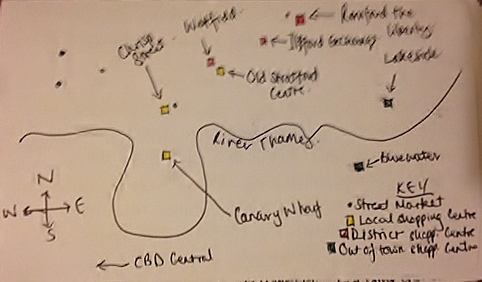
Contenido del mapa
(2) Distribution & variation of retail service provision & ways in which such provision is changing
Changes & reason
- Westfield: Single biggest change. Built for Olympics. Large threshold population (4 million people within 45 minutes)
- Impact: Businesses closing down particularly Illford & Romford. New post code. Development of Stratford City. Stratford International station & large secondary schools being built. Expected to have large negative impact on old Stratford, but didn't happen - different clientele: local people, local income.
- New bus station --> improved accessibility to Stratford.
- Canary Wharf: Canary Wharf changed to provide luxury shops for people with a high income.
- More internet shopping --> Increase in technology. Recession --> People have less money to shop. Olympics --> increased population threshold & traffic.
- Westfield: Single biggest change. Built for Olympics. Large threshold population (4 million people within 45 minutes)
Map
- Lakeside: 250 shops over 11m people a 70 minute drive away. M25/A13/Train from Fenchurch. 500,000 visitors p/week. Anchor stores: M&S, House of Fraser, Debenhams. Free parking spaces.
- Bluewater: 330 shops, 28m visitors p/year, 11m people 1hr drive away. 60 buses p/h/M25/Frequent trains from C. London. Chain stores and brand stores, edge of London. Free parking. High threshold pop.
- Romford the Liberty: 100 shops anchor stores: Debenhams. Attractions - Cinema and Bowling.
- Ilford the Exchange: Over 80 shops, anchor stores M&Sm Debenhams. Shops closing down, big chains moving out. Paid parking spaces. Increase in betting shops, beauty shops and charity shops. Beginning to look run down.
- Canary Wharf: Used by people locally, 200 shops, basic chain sotres e.g. Boots, Topshop, luxury brands as well e.g. Higo Boss, Reiss. Anchor store: John Lewis. Built in the '80s with gov. investment as need for a shopping centre.
- Old Stratford Centre: Aimed at low income people. Mainly food stores e.g. Subway, Sainsburys, local market stalls.
- Chrisp St Market: Local people, mainly stalls and some chain stores e.g. Boots, Iceland.
- Westfield: Trade area is high, threshold pop. - 4m in 45 minutes drive. Opened in Sep 11, cost £1.45bn. Site was available/ brownfield site. Biggest urbvan shopping centre in Europe. Over 300 shops and places to eat, bowling alleys, cinema hotels, office space etc. Anchor stores: John Lewis and M&S. Variety of shops e.g. New Look, Primark, Next, Choice, EE, Boots, WHSmith. Excellent transport links - DLR, Central Line, Jubilee Line, Overground, Eurostar, A12, A13, bus station.
Imágenes y archivos del mapa
Información
- Descripción
- A-Level Geography Mapa Mental sobre (2) Distribution & variation of retail service provision & ways in which such provision is changing, creado por chuckster111 el 23/11/2013.
- Creado por
- chuckster111
- Visitas
- 182
- Etiquetas
- Valoración