
Mapa mental
Geography paper 2 - River processes and Pressures
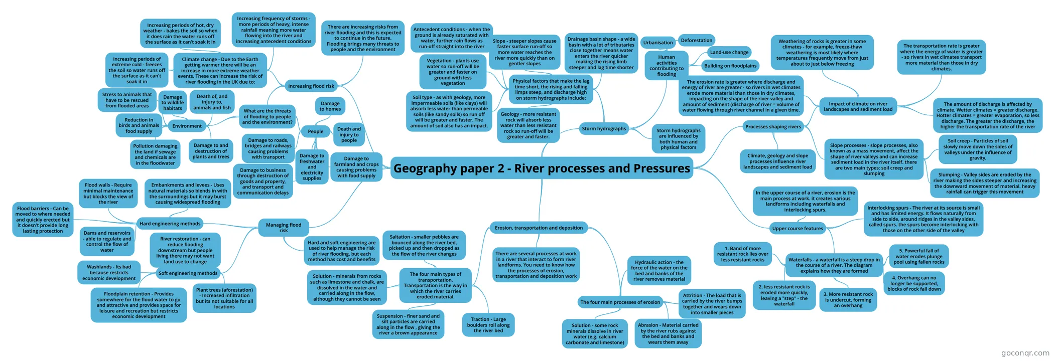
Mind map: Geography paper 2 - River processes and Pressures
Contenido del mapa
Geography paper 2 - River processes and Pressures
Erosion, transportation and deposition
- There are several processes at work in a river that interact to form river landforms. You need to know how the processes of erosion, transportation and deposition work
- The four main processes of erosion
- Hydraulic action - the force of the water on the bed and banks of the river removes material
- Attrition - The load that is carried by the river bumps together and wears down into smaller pieces
- Abrasion - Material carried by the river rubs against the bed and banks and wears them away
- Solution - some rock minerals dissolve in river water (e.g. calcium carbonate and limestone)
- The four main types of transportation. Transportation is the way in which the river carries eroded material.
- Traction - Large boulders roll along the river bed
- Saltation - smaller pebbles are bounced along the river bed, picked up and then dropped as the flow of the river changes
- Suspension - finer sand and silt particles are carried along in the flow , giving the river a brown appearance
- Solution - minerals from rocks such as limestone and chalk, are dissolved in the water and carried along in the flow, although they cannot be seen
Upper course features
- In the upper course of a river, erosion is the main process at work. it creates various landforms including waterfalls and interlocking spurs.
- Waterfalls - a waterfall is a steep drop in the course of a river. The diagram explains how they are formed
- 1. Band of more resistant rock lies over less resistant rocks
- 2. less resistant rock is eroded more quickly, leaving a "step" - the waterfall
- 3. More resistant rock is undercut, forming an overhang
- 4. Overhang can no longer be supported, blocks of rock fall down
- 5. Powerful fall of water erodes plunge pool using fallen rocks
- Interlocking spurs - The river at its source is small and has limited energy. It flows naturally from side to side, around ridges in the valley sides, called spurs. the spurs become interlocking with those on the other side of the valley
Processes shaping rivers
- Climate, geology and slope processes influence river landscapes and sediment load
- Impact of climate on river landscapes and sediment load
- The erosion rate is greater where discharge and energy of river are greater - so rivers in wet climates erode more material than those in dry climates, impacting on the shape of the river valley and amount of sediment (discharge of river = volume of water flowing through river channel in a given time.
- Weathering of rocks is greater in some climates - for example, freeze-thaw weathering is most likely where temperatures frequently move from just about to just below freezing
- The transportation rate is greater where the energy of water is greater - so rivers in wet climates transport more material than those in dry climates.
- The amount of discharge is affected by climate. Wetter climates = greater discharge. Hotter climates = greater evaporation, so less discharge. The greater the discharge, the higher the transportation rate of the river
- Slope processes - slope processes, also known as a mass movement, affect the shape of river valleys and can increase sediment load in the river itself. there are two main types: soil creep and slumping
- Soil creep - Particles of soil slowly move down the sides of valleys under the influence of gravity.
- Slumping - Valley sides are eroded by the river making the sides steeper and increasing the downward movement of material. heavy rainfall can trigger this movement
Storm hydrographs
- Storm hydrographs are influenced by both human and physical factors
- Physical factors that make the lag time short, the rising and falling limps steep, and discharge high on storm hydrographs include:
- Geology - more resistant rock will absorb less water than less resistant rock so run-off will be greater and faster.
- Soil type - as with geology, more impermeable soils (like clays) will absorb less water than permeable soils (like sandy soils) so run off will be greater and faster. The amount of soil also has an impact.
- Vegetation - plants use water so run-off will be greater and faster on ground with less vegetation
- Slope - steeper slopes cause faster surface run-off so more water reaches the river more quickly than on gentler slopes
- Drainage basin shape - a wide basin with a lot of tributaries close together means water enters the river quicker making the rising limb steeper and lag time shorter
- Antecedent conditions - when the ground is already saturated with water, further rain flows as run-off straight into the river
- Human activities contributing to flooding
- Urbanisation
- Deforestation
- Land-use change
- Building on floodplains
Increasing flood risk
- There are increasing risks from river flooding and this is expected to continue in the future. Flooding brings many threats to people and the environment
- Climate change - Due to the Earth getting warmer there will be an increase in more extreme weather events. These can increase the risk of river flooding in the UK due to:
- Increasing frequency of storms - more periods of heavy, intense rainfall meaning more water flowing into the river and increasing antecedent conditions
- Increasing periods of hot, dry weather - bakes the soil so when it does rain the water runs off the surface as it can't soak it in
- Increasing periods of extreme cold - freezes the soil so water runs off the surface as it can't soak it in
- What are the threats of flooding to people and the environment?
- People
- Damage to homes
- Damage to farmland and crops causing problems with food supply
- Death and injury to people
- Damage to roads, bridges and railways causing problems with transport
- Damage to business through destruction of goods and property, and transport and communication delays
- Damage to freshwater and electricity supplies
- Environment
- Death of, and injury to, animals and fish
- Damage to wildlife habitats
- Reduction in birds and animals food supply
- Pollution damaging the land if sewage and chemicals are in the floodwater
- Damage to and destruction of plants and trees
- Stress to animals that have to be rescued from flooded areas
- People
Managing flood risk
- Hard and soft engineering are used to help manage the risk of river flooding, but each method has cost and benefits
- Hard engineering methods
- Embankments and levees - Uses natural materials so blends in with the surroundings but it may burst causing widespread flooding
- Flood walls - Require minimal maintenance but blocks the view of the river
- Dams and reservoirs - able to regulate and control the flow of water
- Flood barriers - Can be moved to where needed and quickly erected but it doesn't provide long lasting protection
- Soft engineering methods
- River restoration - can reduce flooding downstream but people living there may not want land use to change
- Washlands - Its bad because restricts economic development
- Floodplain retention - Provides somewhere for the flood water to go and attractive and provides space for leisure and recreation but restricts economic development
- Plant trees (aforestation) - Increased infiltration but its not suitable for all locations
Información
- Descripción
- Mapa Mental sobre Geography paper 2 - River processes and Pressures, creado por Joe b el 21/04/2021.
- Creado por
- Joe b
- Visitas
- 0
- Valoración