
Mapa mental
Rivers
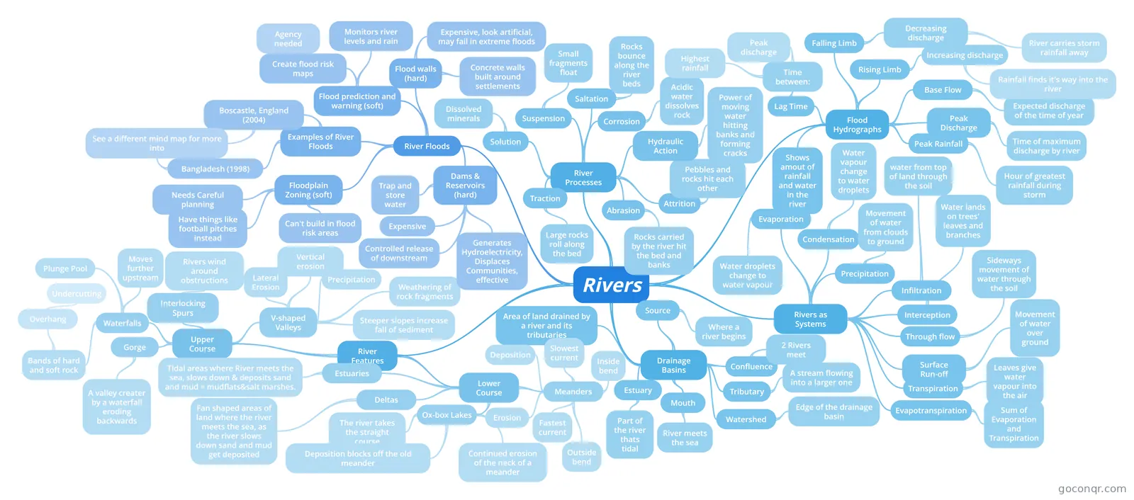
Mind map: rivers geography
Contenido del mapa
Rivers
Rivers as Systems
- Evaporation
- Water droplets change to water vapour
- Condensation
- Water vapour change to water droplets
- Precipitation
- Movement of water from clouds to ground
- Infiltration
- water from top of land through the soil
- Interception
- Water lands on trees' leaves and branches
- Surface Run-off
- Movement of water over ground
- Through flow
- Sideways movement of water through the soil
- Transpiration
- Leaves give water vapour into the air
- Evapotranspiration
- Sum of Evaporation and Transpiration
- Evaporation
Drainage Basins
- Source
- Where a river begins
- Confluence
- 2 Rivers meet
- Tributary
- A stream flowing into a larger one
- Watershed
- Edge of the drainage basin
- Mouth
- River meets the sea
- Estuary
- Part of the river thats tidal
- Area of land drained by a river and its tributaries
- Source
River Processes
- Abrasion
- Rocks carried by the river hit the bed and banks
- Attrition
- Pebbles and rocks hit each other
- Hydraulic Action
- Power of moving water hitting banks and forming cracks
- Corrosion
- Acidic water dissolves rock
- Traction
- Large rocks roll along the bed
- Saltation
- Rocks bounce along the river beds
- Solution
- Dissolved minerals
- Suspension
- Small fragments float
- Abrasion
River Features
- Upper Course
- V-shaped Valleys
- Lateral Erosion
- Vertical erosion
- Precipitation
- Weathering of rock fragments
- Steeper slopes increase fall of sediment
- Interlocking Spurs
- Rivers wind around obstructions
- Waterfalls
- Bands of hard and soft rock
- Overhang
- Undercutting
- Overhang
- Plunge Pool
- Moves further upstream
- Bands of hard and soft rock
- Gorge
- A valley creater by a waterfall eroding backwards
- V-shaped Valleys
- Lower Course
- Meanders
- Erosion
- Deposition
- Slowest current
- Inside bend
- Fastest current
- Outside bend
- Ox-box Lakes
- Continued erosion of the neck of a meander
- The river takes the straight course
- Deposition blocks off the old meander
- Estuaries
- TIdal areas where River meets the sea, slows down & deposits sand and mud = mudflats&salt marshes.
- Deltas
- Fan shaped areas of land where the river meets the sea, as the river slows down sand and mud get deposited
- Meanders
- Upper Course
Flood Hydrographs
- Shows amout of rainfall and water in the river
- Peak Rainfall
- Hour of greatest rainfall during storm
- Peak Discharge
- Time of maximum discharge by river
- Base Flow
- Expected discharge of the time of year
- Rising Limb
- Increasing discharge
- Rainfall finds it's way into the river
- Increasing discharge
- Falling Limb
- Decreasing discharge
- River carries storm rainfall away
- Decreasing discharge
- Lag Time
- Time between:
- Highest rainfall
- Peak discharge
- Time between:
River Floods
- Dams & Reservoirs (hard)
- Trap and store water
- Controlled release of downstream
- Expensive
- Generates Hydroelectricity, Displaces Communities, effective
- Flood walls (hard)
- Concrete walls built around settlements
- Expensive, look artificial, may fail in extreme floods
- Floodplain Zoning (soft)
- Can't build in flood risk areas
- Have things like football pitches instead
- Needs Careful planning
- Flood prediction and warning (soft)
- Monitors river levels and rain
- Create flood risk maps
- Agency needed
- Examples of River Floods
- Boscastle, England (2004)
- See a different mind map for more info
- Bangladesh (1998)
- See a different mind map for more into
- Boscastle, England (2004)
- Dams & Reservoirs (hard)
Información
- Descripción
- (Rivers) Geography Mapa Mental sobre Rivers, creado por Lottie Richards el 12/04/2013.
- Creado por
- Lottie Richards
- Visitas
- 181
- Etiquetas
- Valoración