
Mapa mental
WATER ON THE LAND
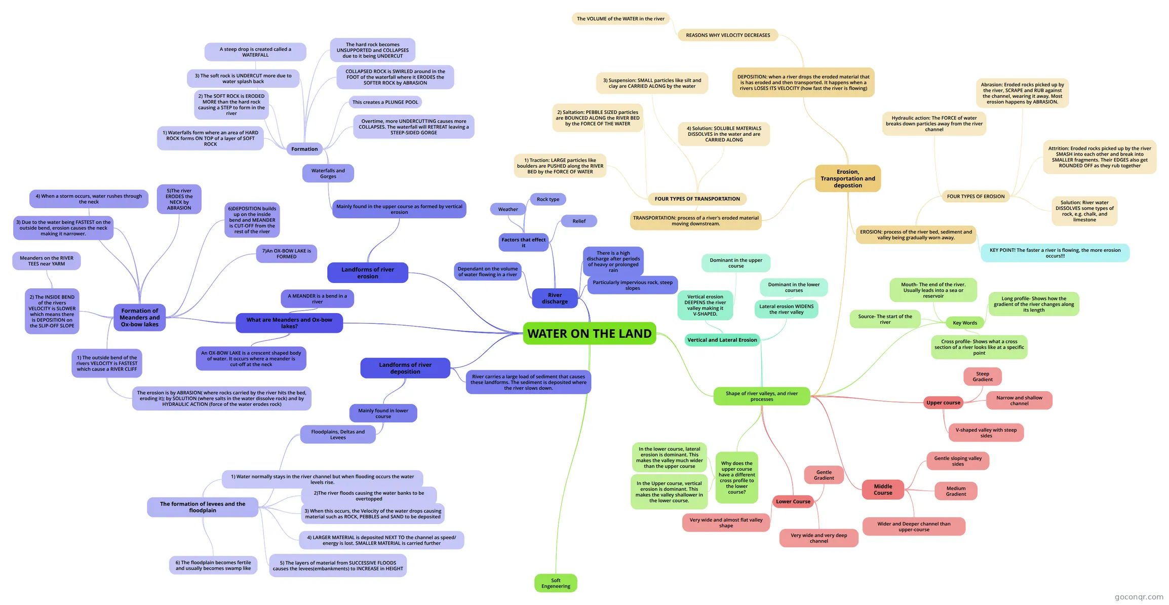
Mind map: Water on the land
Contenido del mapa
WATER ON THE LAND
Shape of river valleys, and river processes
- Upper course
- Steep Gradient
- V-shaped valley with steep sides
- Narrow and shallow channel
- Middle Course
- Medium Gradient
- Gentle sloping valley sides
- Wider and Deeper channel than upper-course
- Lower Course
- Gentle Gradient
- Very wide and almost flat valley shape
- Very wide and very deep channel
- Key Words
- Source- The start of the river
- Mouth- The end of the river. Usually leads into a sea or reservoir
- Long profile- Shows how the gradient of the river changes along its length
- Cross profile- Shows what a cross section of a river looks like at a specific point
- Why does the upper course have a different cross profile to the lower course?
- In the Upper course, vertical erosion is dominant. This makes the valley shallower in the lower course.
- In the lower course, lateral erosion is dominant. This makes the valley much wider than the upper course
- Erosion, Transportation and depostion
- EROSION: process of the river bed, sediment and valley being gradually worn away.
- FOUR TYPES OF EROSION
- Hydraulic action: The FORCE of water breaks down particles away from the river channel
- Abrasion: Eroded rocks picked up by the river, SCRAPE and RUB against the channel, wearing it away. Most erosion happens by ABRASION.
- Attrition: Eroded rocks picked up by the river SMASH into each other and break into SMALLER fragments. Their EDGES also get ROUNDED OFF as they rub together
- Solution: River water DISSOLVES some types of rock, e.g. chalk, and limestone
- KEY POINT! The faster a river is flowing, the more erosion occurs!!!
- FOUR TYPES OF EROSION
- TRANSPORTATION: process of a river's eroded material moving downstream.
- FOUR TYPES OF TRANSPORTATION
- 1) Traction: LARGE particles like boulders are PUSHED along the RIVER BED by the FORCE OF WATER
- 2) Saltation: PEBBLE SIZED particles are BOUNCED ALONG the RIVER BED by the FORCE OF THE WATER
- 3) Suspension: SMALL particles like silt and clay are CARRIED ALONG by the water
- 4) Solution: SOLUBLE MATERIALS DISSOLVES in the water and are CARRIED ALONG
- FOUR TYPES OF TRANSPORTATION
- DEPOSITION: when a river drops the eroded material that is has eroded and then transported. It happens when a rivers LOSES ITS VELOCITY (how fast the river is flowing)
- REASONS WHY VELOCITY DECREASES
- The VOLUME of the WATER in the river
- REASONS WHY VELOCITY DECREASES
- EROSION: process of the river bed, sediment and valley being gradually worn away.
- Vertical and Lateral Erosion
- Vertical erosion DEEPENS the river valley making it V-SHAPED.
- Dominant in the upper course
- Lateral erosion WIDENS the river valley
- Dominant in the lower courses
- Vertical erosion DEEPENS the river valley making it V-SHAPED.
- Upper course
Landforms of river erosion
- Mainly found in the upper course as formed by vertical erosion
- Waterfalls and Gorges
- Formation
- 1) Waterfalls form where an area of HARD ROCK forms ON TOP of a layer of SOFT ROCK
- 2) The SOFT ROCK is ERODED MORE than the hard rock causing a STEP to form in the river
- 3) The soft rock is UNDERCUT more due to water splash back
- A steep drop is created called a WATERFALL
- The hard rock becomes UNSUPPORTED and COLLAPSES due to it being UNDERCUT
- COLLAPSED ROCK is SWIRLED around in the FOOT of the waterfall where it ERODES the SOFTER ROCK by ABRASION
- This creates a PLUNGE POOL
- Overtime, more UNDERCUTTING causes more COLLAPSES. The waterfall will RETREAT leaving a STEEP-SIDED GORGE
- Formation
- Waterfalls and Gorges
- Mainly found in the upper course as formed by vertical erosion
Landforms of river deposition
- Mainly found in lower course
- Floodplains, Deltas and Levees
- The formation of levees and the floodplain
- 1) Water normally stays in the river channel but when flooding occurs the water levels rise.
- 3) When this occurs, the Velocity of the water drops causing material such as ROCK, PEBBLES and SAND to be deposited
- 2)The river floods causing the water banks to be overtopped
- 4) LARGER MATERIAL is deposited NEXT TO the channel as speed/ energy is lost. SMALLER MATERIAL is carried further
- 5) The layers of material from SUCCESSIVE FLOODS causes the levees(embankments) to INCREASE in HEIGHT
- 6) The floodplain becomes fertile and usually becomes swamp like
- The formation of levees and the floodplain
- Floodplains, Deltas and Levees
- River carries a large load of sediment that causes these landforms. The sediment is deposited where the river slows down.
- Mainly found in lower course
What are Meanders and Ox-bow lakes?
- Formation of Meanders and Ox-bow lakes
- 1) The outside bend of the rivers VELOCITY is FASTEST which cause a RIVER CLIFF
- The erosion is by ABRASION( where rocks carried by the river hits the bed, eroding it); by SOLUTION (where salts in the water dissolve rock) and by HYDRAULIC ACTION (force of the water erodes rock)
- 2) The INSIDE BEND of the rivers VELOCITY is SLOWER which means there is DEPOSITION on the SLIP-OFF SLOPE
- Meanders on the RIVER TEES near YARM
- 3) Due to the water being FASTEST on the outside bend, erosion causes the neck making it narrower.
- 4) When a storm occurs, water rushes through the neck
- 5)The river ERODES the NECK by ABRASION
- 6)DEPOSITION builds up on the inside bend and MEANDER is CUT-OFF from the rest of the river
- 7)An OX-BOW LAKE is FORMED
- 1) The outside bend of the rivers VELOCITY is FASTEST which cause a RIVER CLIFF
- A MEANDER is a bend in a river
- An OX-BOW LAKE is a crescent shaped body of water. It occurs where a meander is cut-off at the neck
- Formation of Meanders and Ox-bow lakes
River discharge
- Dependant on the volume of water flowing in a river
- Factors that effect it
- Weather
- Rock type
- Relief
- There is a high discharge after periods of heavy or prolonged rain
- Particularly impervious rock, steep slopes
Soft Engeneering
Información
- Descripción
- Mapa Mental sobre WATER ON THE LAND, creado por laurenahart el 21/12/2013.
- Creado por
- laurenahart
- Visitas
- 8
- Valoración