
Mapa mental
Hydrological Cycle
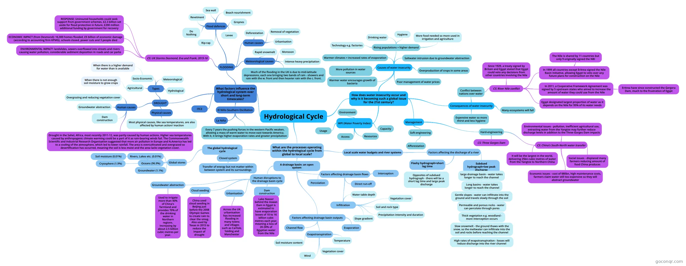
Mind map: Hydrological cycle
Contenido del mapa
Hydrological Cycle
What are the processes operating within the hydrological cycle from global to local scale?
- The global hydrological cycle
- Global stores
- Soil moisture (0.01%)
- Oceans (96.9%)
- Cryosphere (1.9%)
- Rivers, Lakes etc. (0.01%)
- Groundwater (1.1%)
- Closed system
- Transfer of energy but not matter within between system and its surroundings
- Global stores
- A drainage basin: an open system
- Human disruptions to the drainage basin cycle
- Urbanisation
- Across the UK urbanisation has increased flooding in many towns and villages such as Carlisle, Yalding and Manchester
- Cloud seeding
- China used cloud seeding in Beijing just before the 2008 Olympic Games to create rain to clear the smog. Also used by Texas in 2015 to reduce the impact of drought
- Dam construction
- Lake Nasser behind the Aswan Dam in Egypt is estimated to have evaporation losses of 10 to 16 billion cubic metres each year, meaning a loss of 20-30% of Egyptian water from the Nile
- Groundwater abstraction
- Used to irrigate more than 40% of China's farmland and provides 70% of the drinking water in Northern regions. Increasing by about 2.5 billion cubic metres per year.
- Urbanisation
- Factors affecting drainage basin flows
- Percolation
- Infiltration
- Soil and rock type
- Vegetation cover
- Precipitation intensity and duration
- Slope gradient
- Water table depth
- Interception
- Direct run-off
- Factors affecting drainage basin outputs
- Evaporation
- Evapotranspiration
- Temperature
- Vegetation cover
- Soil moisture content
- Wind
- Channel flow
- Human disruptions to the drainage basin cycle
- Local scale water budgets and river systems
- Factors affecting the discharge of a river
- Flashy hydrograph=short lag time
- Opposites of subdued hydrograph - there will be a short lag time and large peak discharge
- Subdued hydrograph=low peak discharge
- large drainage basin - water takes longer to reach the channel
- Long basins - water takes longer to reach the channel
- Gentle slopes - water can infiltrate into the ground and travels slowly through the soil
- Permeable and porous rocks - water can percolate through pores
- Thick vegetation e.g. woodland - more interception occurs
- Slow snowmelt - the ground thaws with the snow, so the meltwater can infiltrate into the soil and rocks before reaching the channel
- High rates of evapotranspiration - losses will reduce discharge into the river channel
- Slow snowmelt - the ground thaws with the snow, so the meltwater can infiltrate into the soil and rocks before reaching the channel
- Thick vegetation e.g. woodland - more interception occurs
- Permeable and porous rocks - water can percolate through pores
- Gentle slopes - water can infiltrate into the ground and travels slowly through the soil
- Long basins - water takes longer to reach the channel
- large drainage basin - water takes longer to reach the channel
- Flashy hydrograph=short lag time
- Factors affecting the discharge of a river
- The global hydrological cycle
What factors influence the hydrological system over short and long-term timescales?
- DROUGHT
- Physical causes
- Most physical causes, like sea temperatures, are also affected by human action/ inaction
- Human causes
- Dam construction
- Groundwater abstraction
- Overgrazing and reducing vegetation cover
- Drought in the Sahel, Africa, most recently 2011-12, was partly caused by human actions. Higher sea temperatures caused by anthropogenic climate warming could be a part of it as rain-bearing winds fail. The Commonwealth Scientific and Industrial Research Organisation suggested that more air pollution in Europe and N.America has led to a cooling of the atmosphere, which led to lower rainfall. The area is overcultivated and overgrazed so desertification has occurred, meaning the soil is less moist and the area lacks vegetation cover.
- Types
- Agricultural
- When there is not enough soil moisture to grow crops
- Socio-Economic
- When there is a higher demand for water than is available
- Meteorological
- Hydrological
- Agricultural
- Physical causes
- FLOODING
- Human causes
- Deforestation
- Urbanisation
- Removal of vegetation
- Meteorological causes
- Intense heavy precipitation
- Much of the flooding in the UK is due to mid-latitude depressions, each one bringing two bands of rain - showers and rain with the w. front and then heavier rain with the c. front.
- Rapid snowmelt
- Monsoon
- CS: UK Storms Desmond, Eva and Frank, 2015-16
- ECONOMIC IMPACT (from Desmond): 16,000 homes flooded, £5 billion of economic damage (according to accounting firm KPMG), schools closed, power cuts and 3 people died
- ENVIRONMENTAL IMPACT: landslides, sewers overflowed into streets and rivers causing water pollution, considerable sediment deposition in roads and car parks
- RESPONSE: Uninsured households could seek support from government schemes, £2.3 billion set aside for flood protection in future, £200 million additional funding by government for recovery
- Flood defences
- Levee
- Sea wall
- Rip-rap
- Groynes
- Beach nourishment
- Do Nothing
- Revetment
- Human causes
- El Niño Southern Oscillation
- Every 7 years the pushing forces in the western Pacific weaken, allowing a mass of warm water to move east towards America. With it, it brings higher evaporation rates and greater precipitation
- La Niña
- ITCZ
- DROUGHT
How does water insecurity occur and why is it becoming such a global issue for the 21st century?
- Consequences of water insecurity
- Expensive water so more thirst and less hygiene
- Conflict between nations over water
- CS: River Nile conflict
- Egypt designated largest proportion of water as it depends on the Nile for 95% of its water needs
- In 2011, a Cooperative Framework Agreement was signed by 5 upstream states who aimed to increase the amount of water they could use from the Nile
- Eritrea have since constructed the Gergera Dam, much to the frustration of Egypt
- In 1999 all countries except Eritrea signed the Nile Basin Initiative, allowing Egypt to veto over any future plans for construction on the Nile
- The Nile is shared by 11 countries but only 9 originally signed the NBI
- Since 1929, a treaty signed by Britain and Egypt stated that Egypt could veto any decisions from other countries involving the Nile
- CS: River Nile conflict
- Many ecosystems will fall
- Causes of water insecurity
- Rising populations = higher demand
- Drinking water
- More food needed so more used in irrigation and agriculture
- Hygiene
- Technology e.g. factories
- Warmer climates = increased rates of evaporation
- Warmer water encourages growth of bacteria
- More pollution in water sources
- Saltwater intrusion due to groundwater abstraction
- Overproduction of crops in some areas
- Poor management of water prices
- Rising populations = higher demand
- WPI (Water Poverty Index)
- Resources
- Access
- Capacity
- Usage
- Environment
- Management
- Hard-engineering
- CS: China's South-North water transfer
- It will be the largest in the world, delivering 25bn cubic metres of water from the Yangtze to Northern China
- Environmental issues - pollution, inefficient agricultural use, extracting water from the Yangtze may further reduce discharge levels in addition to the Three Gorges Dam impacts
- Social issues - displaced many farmers reducing amount of food China produces
- Economic issues - cost of $80bn, high maintenance costs, farmers claim water still too expensive so they will abstract groundwater
- CS: Three Gorges Dam
- CS: China's South-North water transfer
- Soft-engineering
- Afforestation
- Hard-engineering
- Consequences of water insecurity
Información
- Descripción
- Definitions of key terms are on my Quizlet page. Search for oliver_downes and go to 'Hydrological Cycle and Weather'.
- Creado por
- Oliver Downes
- Visitas
- 80
- Etiquetas
- Valoración