
Mapa mental
Tectonic Hazard Management: Case Studies
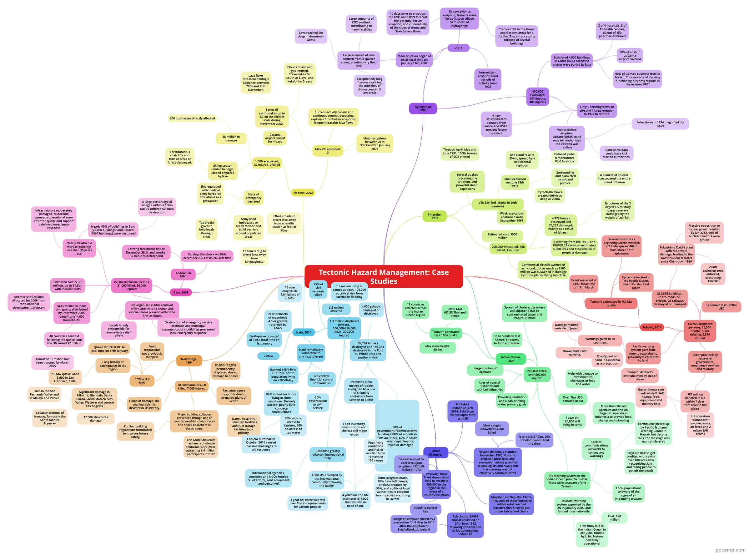
Mind map: Tectonic hazard management case studies
Contenido del mapa
Tectonic Hazard Management: Case Studies
Bam, 2003
- 6.6Mw, 9.0 MMI
- Earthquake struck on 26th December 2003 at 05:26 local time
- 2 strong foreshocks felt on December 25th, and another 30 minutes beforehand
- 75,000 displaced persons, 31,000 killed, 30,000 injured
- Nearly all who did were in buildings less than 30 years old.
- Nearly 90% of buildings in Bam (25,000 buildings) and Baravat (4000 buildings) were destroyed
- A large percentage of villages within a 10km radius suffered 60-100% destruction
- Infrastructure moderately damaged, to become generally operational soon after the quake and support a delayed emergency response
- Nearly 90% of buildings in Bam (25,000 buildings) and Baravat (4000 buildings) were destroyed
- Estimated cost: $32.7 million, up to $1.5bn with indirect costs
- No organised rubble removal effort, and thus no search and rescue teams present within the first 24 hours
- Locals largely responsible for immediate relief effort
- Destruction of emergency service premises and municipal communications buildings prevented local emergency response
- $645 million in loans and grants distributed by December 2005, benefitting14,000 households.
- Another $445 million allocated for 2006 from Iran's national development program
- 40 countries sent aid following the quake, and the UN raised $7 million
- Almost $131 million had been donated by March 2005
- Nearly all who did were in buildings less than 30 years old.
- 6.6Mw, 9.0 MMI
Northridge, 1994
- 6.7Mw, 9.0 MMI
- Quake struck at 04:34 local time on 17th January
- Long history of earthquakes in the region
- 7.8 Mw quake killed 3,000 in San Francisco, 1906.
- Fault responsible not previously mapped.
- 20,000 homeless, 60 killed, 7,000 injured
- $20bn in damage, the costliest seismic disaster in US history
- Significant damage in Fillmore, Glendale, Santa Clarita, Santa Monica, Simi Valley, Western and central Los Angeles
- Fires in the San Fernando Valley and at Malibu and Venice
- Collapse sections of freeway, famously the Santa Monica Freeway
- 12,000 structures damagd
- Significant damage in Fillmore, Glendale, Santa Clarita, Santa Monica, Simi Valley, Western and central Los Angeles
- 80,000-125,000 permanently displaced due to damage to homes
- Major building collapse prevented though use of counterweights, cross-braces and shock absorbers in skyscrapers
- Further building regulations introduced to improve future safety.
- The Grate Shakeout has been running in California since 2008, attracting 9.4 million participants in 2012
- Fast emergency response due to prepared plans of action
- Dams, hospitals, industrial facilities and fuel storage facilities took priority.
- $20bn in damage, the costliest seismic disaster in US history
- 6.7Mw, 9.0 MMI
Haiti, 2010
- 7.0Mw
- Earthquake occurred at 16:53 local time on 1st January
- 59 aftershocks of magnitude 4.5 or greater recorded by USGS
- 16 over magnitude 5.0,highest of 6.0Mw
- 59 aftershocks of magnitude 4.5 or greater recorded by USGS
- Earthquake occurred at 16:53 local time on 1st January
- 1.3 million displaced persons, 100,000-316,000 dead, 300,000 injured
- 97,294 houses destroyed and 188,383 destroyed in the Port au Prince area and southern Haiti
- 4,000 schools damaged or destroyed
- 60% of government//administrative buildings, 80% of schools in Port au Prince, 60% in south and west departments, destroyed or damaged
- 19 million cubic metres of rubble, enough to fill a line of shipping containers from London to Beirut
- 3.5 million affected
- 1.5 million living in camps at peak, 100,000 at critical risk from storms or flooding
- 25% of civil servants killed
- Response greatly relianton international help
- International agencies, countries and NGOs funded relief efforts, sent equipment and personnel
- 3.6bn USD pledged by the international community following the quake
- 1 year on, there was still over 1bn in requirements for various projects
- 4 years on, the UN estimates 817,000 Haitians still in need of aid.
- Poor living conditions, and risk of eviction from remaining 106 camps
- Food insecurity, malnutrition and cholera still major issues
- Some progress made: 89% have left camps, cholera dropped by 50%, and ability of local authorities to respond has improved according to Oxfam.
- 97,294 houses destroyed and 188,383 destroyed in the Port au Prince area and southern Haiti
- Haiti remarkably vulnerable to any hazard event
- Ranked 145/169 in HDI. 70% of the population living on <2USD/day
- 86% in Port au Prince living in slum conditions. Densely packed, poorly built concrete constructions
- 50% with no access to latrines, 66% no access to tap water
- Cholera outbreak in October 2010 caused massive challenges to aid response
- 86% in Port au Prince living in slum conditions. Densely packed, poorly built concrete constructions
- No central financial control of ministries
- 30% absenteeism in civil service
- Ranked 145/169 in HDI. 70% of the population living on <2USD/day
- 7.0Mw
Nyiragongo, 2002
- VEI: 1
- Intermittent eruptions and periods of activity since 1928
- 13 days prior to eruption, tremors were felt at Rusayo village, 5km south of Nyiragongo
- 10 days prior to eruption, the GVO and CRSN forecast the potential for an eruption, and vulnerability of the cities of Goma and Sake to lava flows
- Tremors felt in the Goma and Gesenyi areas for a further 3 months, causing collapse of several buildings
- Main eruption began at 08:35 local time on January 17th, 2002
- Large amounts of lava emitted from 3 spatter cones, creating very fluid lava
- Large amounts of CO2 emitted, contributing to many fatalities
- Exceptionally long fissures reaching the outskirts of Goma created 3 lava trails
- Lava reached 2m deep in downtown Goma
- Large amounts of lava emitted from 3 spatter cones, creating very fluid lava
- 400,000 evacuated, 147 deaths, 400 injuries
- Estimated 4,500 buildings in Goma (40%) collapsed and/or were buried by lava
- 2 of 4 hospitals, 3 of 11 health centres, 80 out of 150 pharmacies buried
- 80% of airstrip at Goma airport covered
- 90% of Goma's business district buried. This was one of the only functioning business regions in the eastern DRC.
- Only 2 seismographs on site and 1 large eruption in 1977 to refer to.
- Weeks before eruption, volcanologists could only tell authorities the volcano was restless
- False alarm in 1994 magnified the issue
- Conclusive data could have kick started authorities.
- 4 new seismometers donated from France and USA to prevent future disasters.
- Weeks before eruption, volcanologists could only tell authorities the volcano was restless
- Estimated 4,500 buildings in Goma (40%) collapsed and/or were buried by lava
- VEI: 1
Pinatubo, 1991
- VEI: 6.0 (2nd largest in 20th century)
- Several quakes preceding the eruption, and powerful steam explosions
- Through April, May and June 1991, 1000s tonnes of SO2 emited
- Main explosion on June 15th 1991.
- Ash cloud rose to 35km, spread by a coincidental typhoon
- Reduced global temperatures 05-0.6 celcius
- Surrounding land blanketed by ash and pumice
- A blanket of at least 1cm covered the entire island of Luzon
- Pyroclastic flows created debris as deep as 200m
- Ash cloud rose to 35km, spread by a coincidental typhoon
- Weak explosions continued until September 1991
- Several quakes preceding the eruption, and powerful steam explosions
- 200,000 evacuated, 450 killed, 4 injured
- 4,979 homes destroyed and 70,257 damaged, mainly as a result of lahars.
- Structures of the 2 largest US military bases severely damaged by the weight of ash fall.
- A warning from the USGS and PHIVOLCS saved an estimated 5,000 lives and $250 million in property damage
- Commercial aircraft warned of ash cloud, but as much as $100 million was sustained in damage by those planes flying too close
- Estimated cost: $500 million
- 4,979 homes destroyed and 70,257 damaged, mainly as a result of lahars.
- VEI: 6.0 (2nd largest in 20th century)
Mt Etna, 2002
- Max VEI recorded: 3
- Current activity consists of continuos summit degassing, explosive Stombolian eruptions, frequent basaltic lava flows
- Major eruptions between 26th October-28th January 2003
- Series of earthquakes up to 4.3 on the Richter scale during November 2002.
- Clouds of ash and gas emitted. Travelled as far south as Libya, and Kefalonia, Greece
- Lava flows threatened Rifugio Sapienze between 20th and 21st November.
- 1,000 evacuated, 32 injured, 0 killed
- $8 million in damage
- 300 businesses directly affected
- Catania airport closed for 4 days
- Skiing season unable to begin. Sloped engulfed by lava
- 1 restaurant, 3 chair lifts and 100s of acres of forest destroyed.
- State of emergency declared
- Army used bulldozers to break tarmac and build barriers around populated areas
- Efforts made to divert lava away from scientific station at foot of Etna
- Channels dug to divert lava away from Linguaglossa
- Ship equipped with medical clinic harbored off Catania as a precaution
- Tax breaks given to help locals through crisis
- Army used bulldozers to break tarmac and build barriers around populated areas
- $8 million in damage
- Max VEI recorded: 3
Indian Ocean, 2004
- Tsunami generated by 9.1Mw quake
- 00:58 GMT (07:58 Thailand time)
- Max wave height: 50.9m
- 18 countries affected across the Indian Ocean region
- 226,898 killed, over 500,000 injured
- Up to 5 million lost homes, or access to food and water
- Spread of cholera, dysentery and diptheria due to contaminated water and tropical climate
- Loss of coastal fisheries and tourism industries
- Largenumber of orphans
- Over 7bn USD donated in aid
- Help with damage to infrastructure, shortages of food and water
- More than 160 aid agencies and the UN began to operate in Indonesia to provide food, shelter and schooling
- 1 year on, 60,000 still living in tents
- Providing sanitation and clean drinking water primary goals
- No warning system in the Indian Ocean prior to disater. Most were unaware of the Tsunami
- Lack of communications networks to convey any warnings
- Earthquake picked up by Pacific Tsunami Warning Centre in Hawaii, but despite calls, the message was not transferered
- Local populations unaware of the signs of an impending tsunami
- 10 yr old British girl credited with saving over 100 lives after recognisingsigns and telling people to get off the beach
- Tsunami warning system approved by the UN in January 2005, and funded internationally
- Cost: $20 million
- First buoy laid in the Indian Ocean in late 2006, funded by USA. System now fully operational
- Lack of communications networks to convey any warnings
- Tsunami generated by 9.1Mw quake
Tohoku, 2011
- Tsunami generated by 9.0 Mw quake
- Event recorded at 14:46 local time on 11th March
- Several foreshocks beginning March 9th with a 7.2 Mw quake, 40km from March 11th epicentre.
- Epicentre located in the Pacific Ocean, near Honshu, East Japan
- 130,927 displaced persons, 15,550 deaths, 5,344 missing, 5,314 injured
- 332,395 buildings, 2,125 roads, 56 bridges, 26 railways destroyed or damaged
- Fukushima Daichi plant suffered severe damage, leading to the worst nuclear disaster since Chernobyl, 1986
- 20km exclusion zone enforced, evacuating 150,000
- Massive opposition to nuclear power resulted. By Jan 2012, 90% of nuclear reactors were offline
- Fukushima Daichi plant suffered severe damage, leading to the worst nuclear disaster since Chernobyl, 1986
- Economic loss: 309bn USD
- Pacific warning system gave little time to react due to proximityof epicentre to land
- Warnings given to 50 countreis
- Damage minimal outside of Japan.
- Hawaii had 5 hrs warning.
- Coastguard on hand in California as a precaution
- Tsunami defences overwhelmed by size of wave
- Warnings given to 50 countreis
- Relief provided by Japanese government, emergency services and military
- $87 million donated in aid within 7 days from around the globe
- Governments sent medical staff, SAR teams, food, equipment and military help
- US operation "Tomodachi" involved navy, air force and 2 urban SAR teams
- Governments sent medical staff, SAR teams, food, equipment and military help
- $87 million donated in aid within 7 days from around the globe
- 332,395 buildings, 2,125 roads, 56 bridges, 26 railways destroyed or damaged
- Tsunami generated by 9.0 Mw quake
Other Examples
- Mt Kelud, Indonesia, Feb 2014: 3 die from roof collapse after ash fall
- Nevado del Ruiz, Colombia, November 1985: Volcanic eruption predicted, and evacuation advice given by seismologists and NGOs, but the message wasnot effectively communicated
- Most caught unaware: 23,000 killed
- Total cost: $7.7bn, 20% of Colombian GDP at the time
- Vesuvius, Italy: Plans drawn up in 1995 to evacuate 600,000 in the region in the event of a volcanic eruption
- Avoiding panic is key
- Seawater used to cool lava upon eruption of Eldfell, Iceland, 1973
- Ash clouds: BA009 almost creashed on 24th June 1982 following the eruption of Mt Galunggung, Indonesia
- European airspace closed as a precaution for 8 days in 2010 after the eruption of Eyjafjallajokull, Iceland
- Tangshan earthquake, China, 1976: 80% of those buried by rubble were rescued because they knew to get under tables and chairs
Información
- Descripción
- Mapa Mental sobre Tectonic Hazard Management: Case Studies, creado por A K el 28/05/2014.
- Creado por
- A K
- Visitas
- 201
- Etiquetas
- Valoración