
Test
11/12
Crea una cuenta gratis para terminar este test
Guarda tu progreso y consulta tu resultado final.
¿Ya tienes cuenta? Inicia sesión
Preguntas del test (23)
1Why is the eye region of a hurricane largely free of precipitation and heavy clouds?
- Asinking air motion
- Brising air motion
- Cpressure gradient is weaker
- Dcooler temperatures
2What general circulation wind belt is the place of origin for hurricanes?
- Awesterlies
- Btrade winds
- Cdoldrums
- Dhorse latitudes
3When the upper-air exhibits a general ________ flow, cyclonic systems tend to move through quickly, creating rapidly changing weather conditions.
- AW to S
- BN to S
- CN to E
- DW to E
4You'd like to plan a Christmas day flight to visit family. You have several months lead time. How might you determine the probability of snowfall occurring and potentially interfering with your travel plans?
- Aconsult a climatological forecast
- Bwatch the weather forecast
- Crefer to the an along forecast
- Droll the dice
5Which of the following rely on the fact that gases of the atmosphere obey a number of known physical principles to predict the future state of the atmosphere?
- Anumerical weather prediction
- Bstatistical methods
- Ctrend forecasting
- Dpersistence forecasting
6These types of images are views of the earth the way an astronaut would see our planet from space.
- Ainfared images
- Bvisible images
- Cmoon images
- Dwater vapor images
7The acronym NOAA stands for:
- ANational Oceanic and Atmospheric Administration.
- BNational Observatory for Atmospheric Assessment.
- CNightly Observation of Atmospheric Attributes.
- DNumerical Observation Assessment Association.
- ANational Oceanic and Atmospheric Administration.
8Cyclone Nargis made landfall in:
- ABangladesh
- BMyanmar
- CAustralia
- DJapan
9Why are most weather data displayed in the form of a map or chart?
- Amore data can be recorded on a map
- Bmaps are easier to remember
- Cmaps display the data in their proper place, relative to other data, and allow the identification of patterns
- Dmaps are easier to construct than tables
10________ predict(s) that future weather will be the same as the present weather conditions.
- Athe analog method
- Bpersistence forecasts
- Ctrent forecasting
- Dnowcasting
11What is the current air temperature represented on the station model shown above?
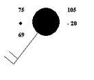
- A75 F
- B75 C
- C69 F
- D-20 C
12The forecasts for local and regional weather are produced by:
- Aweather forecast offices
- Bnational cyclone center
- Cstate weather forecast offices
- Dnational centers for environmental prediction
13When a cyclone's strongest winds do not exceed 37 miles per hour it is called a:
- Atropical depression
- Btropical storm
- Ctornado
- Dhurricane
14As a strong hurricane moves ashore, which of the following causes the most devastating damage in the coastal zone?
- Astorm surge
- Bstrong winds
- Ctorrential rains
- Dlightening
15Why do surface wind speeds increase toward the center of a hurricane?
- Areduced friction
- Bstronger coriolis effect
- Cconservation of angular momentum
- Dwarmer water
16What system is used to name hurricanes if the established list of names is exhausted in a given year?
- Alatitude/longitude
- Bthe greek alphabet
- CUS presients
- Droman numerals
17When occurring in the Atlantic Ocean they are known as hurricanes. What are they known as when occurring in the western Pacific?
- Atyphoons
- Btropical breezes
- Ctsunamis
- Dcyclones
18What determines when a tropical depression or storm is given hurricane status?
- Awater temperature
- Bwind speed
- Cdiameter
- Dcentral pressure
19Long range forecasts (monthly or seasonal) include predictions of:
- Apressure
- Btemperature
- Cprecipitation
- Dtemperature and precipitation
20Since detection and tracking of hurricanes is now quite accurate, why does damage from these storms continue to increase?
- Acontinued development of coastal areas
- Bpoor forecasts of landfall area
- Cchanges in tidal patterns
- Dhurricane intensity is greater
21Hurricanes form
- A35-50 degree latitude
- B20-35 degree latitude
- Cat the equator
- D5-20 degree latitude
22Why are some satellites described as being stationary?
- ATheir orbital motion matches the earth's rotation.
- BThey orbit over the earth's poles.
- CThey have no orbital motion.
- DThey can only observe stationary weather systems.
- ATheir orbital motion matches the earth's rotation.
23Upper-air maps are commonly drawn for all the following pressures, except:
- A500 mb
- B700 mb
- C850 mb
- D1000 mb
Información
- Descripción
- Test sobre 11/12, creado por astrass132 el 09/12/2014.
- Autor
- astrass132
- Idioma
- English
- Visitas
- 2
- Valoración
- Aún sin valoraciones Valora este test