318304
Description
Flashcards by Anna Hollywood, updated more than 1 year ago
|
|
Created by Anna Hollywood
over 10 years ago
|
|
| Question | Answer |
| precipitation | rain/hail/snow/sleet |
| stem and drip-flow | water dripping and falling from plants |
| infiltration | water soaking into soil |
| through flow | water flowing sideways through the soil and towards the stream |
| Percolation | some water soaks down and fills up cracks & pores in bedrock - it's now groundwater |
| groundwater flow | water flowing through the saturated bedrock and towards the river |
| channel flow | water flowing into the river |
| transpiration | water vapour breathed out by plants |
| evaporation | water turning into water vapour |
| interception | leaves catching rain |
| surface runoff | when water flows overground |
| permeable | it lets water seep through |
| how is water storage split up? | salt water - 97.5% fresh water - 2.5% *lakes/rivers-0.3% *underground-30.8% *ice-68.9% |
| biosphere | the areas of the world (land, ocean & atmosphere) inhabited by living organisms |
| lithosphere | The solid part of the earth (crust and upper mantle) |
| hydrosphere | the process of water moving between the land and the atmosphere |
| why does planting trees slow down the water cycle? | Because the leaves act as a temporary water storage until it drips to the ground or evaporates |
| Why don't some clouds precipitate? | Because if evaporation doesn't occur from oceans, the clouds don't have chance to build up droplets until it's enough to rain/sleet/snow etc |
| Explain why the biosphere and lithosphere are important to the hydrological cycle (4) | The biosphere includes the process of interception; so without trees and vegetation storing water temporarily and transpiring it back into the atmosphere, there would be floods. Also lithosphere includes surface run off and without this allowing water to flow into lakes and rivers, flooding would also occur. |
| Name the stores of water | -Interception -Surface water storage -Soil water storage -Groundwater storage |
| Name the water flows | -Surface run off -Infiltration -Through flow -Percolation -Groundwater flow |
| What is the main input in a drainage basin | Precipitation |
| What are the main outputs in a drainage basin? | Transpiration Evaporation Surface runoff |
| Drainage basin system | The area of land where the river gets its water from |
| Why is having an equal input and output good in a drainage basin system? | So you don't get floods or droughts |
|
Image:
000000000000000 (image/png)
|
|
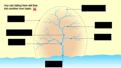
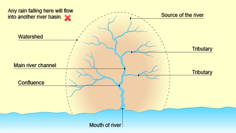
| tributary | a smaller river that joins the main river |
| source | where the river starts |
| confluence | the point where two rivers join |
| mouth | where the river flows into the sea or a lake |
| water stress | an area that uses more water than it has |
| physical scarcity | shortage occurs when demand exceeds supply |
| economic scarcity | when people cannot afford water, even though it maybe readily available |
| how has water stress affected australia | -decade long dry spell since 1990s -in 2007, murray river levels at lowest -rainfall decreased to 25% of long term average -Bush fires - Over use of water for farming -crop yield fallen by half causing rising food prices - wells are drying up -hundreds of winemakers could be forced out of their AU$2.6 bill business |
| what are the 6 causes of water shortage | -Population growth -agriculture demands -urbanisation -industry -climate change -energy |
| Name 2 ways in how water resources can be sustainably managed | - Stopping polluting (from calcium sulphides put into lakes and rivers to stop cholera spreading) - Banning plastic bags in rivers and lakes as they can clog pipes, cause flooding and create warm pools which can be a good home for malaria-bearing mosquitoes |
| Describe the coca cola sustainable management story | -Coca cola found an aquifer in a drought prone area in india - It needed this groundwater supply to add to the coke and boost sales in india - set up the firm -they built 6 wells -in 2004 water stress was present in Plachimada where they built the bottling plant - they contributed to the water stress -coca cola gave the town free tankers of fresh water |
| C&B Colorado dam creating reservoirs | Cost-Loss of land flooded by reservoir Benefit-Regular all year water supplies for cities live Las Vegas |
| C&B Colorado dam Trap sediment behind dams | Cost-Shrinking sandbanks ---> animals loss of habitat ---> tourists lose rafting |
| C&B Colorado dam Regulates river flow | Cost- Less energy left to move sediment(which keeps the water warm for fish) Benefit-Less flood risk |
| desertification | the process of land being turned into desert because of various activities including climatic change and human activities |
| How can increase in population result in desertification? | deforestation for fire wood --> roots no longer hold the soil together --> leaves no longer protect soil from weather --> loose top soil blown away by wind (soil erosion) |
| How can increase in cattle result in desertification? | Grassland grazed more intensively --> roots may be eaten as well as grass --> less vegetation means less protection from weather --> loose top soil blown away by wind (soil erosion) |
| watershed | peak of mountain where water comes from (top edges of basin) |
| discharge | the volume of water moving through the river at any one given time |
| What are the characteristics and features of the upper course of a river? | - V shaped valley - Narrow channel - High bedload - Interlocking spurs - Waterfalls - Gorges |
| What are the characteristics and features of the middle course of a river? | - Gentle sloping valley - Flood plain -Wider/deeper channel - More suspended sediment - Meanders - River cliffs - Slip off slopes |
| What are the characteristics and features of the lower course of a river? | - Open/gentle sloping valley with flat and wide flood plain - Wide, open valley - Very wide and very deep channel - Ox-bow lakes - Levees |
| Vertical erosion | River eroding downwards into river bed, happens mainly in river's upper course |
| Lateral erosion | River eroding sideways into the banks of the river to make it wider. Happens mainly in middle and lower courses |
| Abrasion | Sand and stones in the river scrape the bed and banks and wear them away |
| Attrition | Rocks and stones knock together and wear each other away |
| Hydraulic action | In a fast-flowing river, water is forced into cracks in the bank. Over time it breaks up the bank |
| Solution | River water dissolves some rock types (chalk and limestone) |
| What are the 5 methods of transportation in a river? | - Traction - Saltation - Suspension - Solution - Deposition |
| Traction | Large particles like boulders are pushed along the river bed by the force of the water |
| Saltation | Pebble-sized particles are bounced along the river bed by the force of the water |
| Suspension | Small particles like silt and clay are carried along by the water |
| Solution | Soluble materials like sodium and calcium dissolve in the water and are carried along |
| Deposition | Where the river drops the heavy load due to a loss in velocity and energy. Signs of this include areas of pebbles, silt, mud, sand and stones |
| How are waterfalls formed? | When water flows over areas of hard and soft rock. The soft rock gets eroded quicker forming a 'step'. Hydraulic action makes the plunge pool and notch bigger. The hard rock ledge collapses into plunge pool. Corrasion makes plunge pool bigger. Erosion forces the waterfall to retreat upstream, forming a gorge and waterfall. |
| Meanders | - The current is faster on the outer bend of the river as it's deeper (less friction) - River cliffs form - A point bar is formed where there is deposition and sediment collects - The slip off slope is the gentle slope towards the point bar |
| Ox-bow lakes | -Faster water erodes the outside bends and the river becomes more sinuous - The meander bend gets tighter - When it floods, hydraulic action and abrasion can form a new channel - The river takes the shortest course - Deposition cuts off the meander forming an ox-bow lake |
| Flood plain | Wide valley floor on either side of river that usually gets flooded. When a river floods onto the flood plain, the water slows down and deposits the eroded material that it's transporting. This builds up the flood plain. Meanders migrate across the flood plain making it wider. The deposition that happens on the slip-off slopes of meanders also builds up the flood plains. |
| Levees | They are artificial or natural embankments along the edges of a river channel. Natural levees are built up over time from debris and sediment whereas artificial levees are man made using sand bags and large rocks. This process involves traction (during flooding). |
| What does a hydrograph show? | How the discharge at a certain point in a river changes over time |
| What is the rising part on a hydrograph? | The rising limb |
| What is the top part of the hydrograph called? | The peak flow |
| What does the bar chart at the bottom of the hydrograph show? | Peak rainfall |
| What's the downhill part of the hydrograph called? | Recession limb |
| Would an urban area have a high or low peak rainfall and a high or low lag time? Why? | High peak Short lag time due to surface run off |
| Would a rural area have a high or low peak rainfall and a high or low lag time? Why? | Low peak Long lag time due to infiltration |
| Would a forest have a high or low peak rainfall and a high or low lag time? Why? | Low peak - water stored in plants Long lag time due to interception |
| Would a deforested area have a high or low peak rainfall and a high or low lag time? Why? | High peak - less water stored in plants Short lag time - No interception, faster surface run off |
| What conditions can change a hydrograph? | - Time of year - Amount of vegetation - Length/steepness of surface run off - Intensity of rainfall - Location - Development - Type of soil/ground/rock - Channel density(number of streams) |
| Hard engineering | Structures that are imposed on the river and try to control the river. |
| Soft engineering | They work with the river and use natural processes |
| 5 examples of hard engineering | Dams, embankments, straightening and deepening the river, storage areas and flood walls |
| 4 examples of soft engineering | washlands, land-use zoning, afforestation and warning systems |
| Dams adv + disadv | Huge walls built across the rivers, usually in the upper course. Adv- generate electricity and are sustainable Disadv- Change the ecosystem, flood land, trap sediment & are very expensive |
| Embankments adv + disadv | a wall or bank of earth or stone built to prevent a river flooding an area adv-protect land and are very effective in making the river deeper disadv- expensive and unnatural |
| Channel straightening | The river's course is straightened - meanders are cut out by building artificial straight channels adv- Prevents build up of water and therefore flooding in a certain area disadv - changes ecosystem, is unnatural and river can flood elsewhere |
| Storage areas adv+disadv | adv- prevents flooding by storing up water and then putting it back in the river disadv- you need enough land |
| Flood walls adv and disadv | artificial walls built to keep back floods adv- prevents flood damage disadv- quite expensive and unnatural |
| washlands adv+disadv | land that is periodically flooded by a river or stream adv- saves more important areas being flooded disadv- takes away use of football pitches and nature reserves. they can't be built on |
| Land-use zoning adv+disadv | Where land has different building controls depending on how far away from the river it is adv- aren't any houses or roads to damage, reduces impact of flooding disadv- no help on areas that have already been built on and its impratical |
| afforestation adv+disadv | replanting trees in the catchment adv- interception will reduce flood risks disadv- time consuming and expensive |
| warning systems adv+disadv | people are warned about possible flooding through tv, radio, newspapers and the internet adv- flood impact reduced, gives people time to move valuables, put out sandbags and evacuate disadv- people may not hear or have access to flood warnings and they don't actually stop the flood from happening |
| How are potholes formed? | Holes drilled into river bed by fast, turbulent water loaded with pebbles. They become trapped in the small gaps in the river bed and become caught up in the vertical currents. The currents drill down and the sediment grinds a hole in the rock through abrasion. Found in upper course as the bed is more likely to be rocky here. |
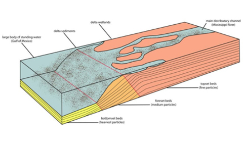
| What's a delta? | A low-lying area where a river meets the sea or a lake |
| How are deltas formed? | From the deposition of sediment carried by the river. Over time the deposition builds up to form a delta |
| What are the 3 types of delta? | arcuate, birds foot and cuspate |
| Arcuate delta | River splits many times creating a fan effect |
| Birds foot delta | When the river splits, each part juts out into the sea forming a birds foot look |
| Cuspate delta | The land around the mouth of the river juts out 'arrow-like' into the sea |
| Which rocks are deposited first and how - in the formation of a delta | the heavier rocks by traction |
| Which rocks are deposited second and how - in the formation of a delta | Small stones by saltation - the sediment builds up |
| Which rocks are deposited last and how - in the formation of a delta | Dissolved material by solution |
| Weathering | The breakdown of rocks and minerals by physical and chemical processes |
| Mass movement | On the sides of river valleys, this process involves transferring broken rock, mineral, soil and vegetation down the valley slope |
| Geology | Influences valley shape and sediment load e.g. where a river flows over bands of resistant rock, the valley slopes tend to be steep and the load small (due to slow erosion) |
| What's freeze thaw? | Where water gets into cracks in rocks, freezes, then expands, cracking the rock |
| What's acid rain? | Where acidic fumes turn into clouds and rain down on limestone, corroding it away |
| What's biological weathering? | Where tree roots break through concrete in roads for example cracking and breaking it |
| Link the effects of weathering, mass movement and geology to the landforms we have studied | Weathering influences the amount of erosion in rivers. It speeds up the process of erosion in the form of acid rain and adding more sediment into the river. However, weathering decreases the speed of deposition |
| Name 10 ways of how a healthy hydrological cycle can be threatened by humans | Deforestation, municipal sewage discharge, storm-water runoff, industrial discharge, landfill, crop spraying, irrigation, excessive fertiliser application, livestock waste, chemical application to parks, lawns and golf courses |
|
Image:
delta2 (image/png)
|
Image:
delta (image/jpg)
|
| Flow chart for urbanisation | urbanisation -> people need water for supplies -> take water from reservoirs & groundwater storage -> over-abstraction -> river flow drops -> streams dry up -> damage to ecosystem -> water levels drop -> drought |
| Flow chart for reservoir building | Build a reservoir -> forms a lake -> no water flowing downstream -> villages lower down the river don't get the water supply -> more concentrated pollution -> fish and plants die -> lack of water -> go into groundwater supplies -> water levels drop -> drought |
| Flow chart for deforestation | Deforestation -> less transpiration (reduction in rainfall) & surface exposed -> soil is heated making it hard -> soil becomes impermeable -> increases surface runoff -> loss of soil nutrients -> rain washes out finer soil particles leaving behind a coarser, heavier sand surface -> no interception due to no leaves -> increase of siltation in rivers and increased flood risk |
| Why are there problems between people concerning the Colorado river dam? | Farmers, urban dwellers and Mexicans all want water from the river. Native Americans won't be happy because it will ruin their scenery and disturb their settlements |
| How does the biosphere and atmosphere link with the hydrological cycle? | Precipitation and evaporation |
| How does the biosphere and lithosphere link with the hydrological cycle? | Water drops off leaves onto ground and water flows off land or through it into rivers |
| How does the lithosphere and atmosphere link with the hydrological cycle? | Water evaporates off of ground surface and precipitation falls onto unvegetated ground |
| How do agricultural demands cause water shortage and give 2 examples of this | Growing population needs more food (crops) and the area of irrigated land doubled in the twentieth century - Australia and Kenya |
| How does urbanisation cause water shortage and give 2 examples of this | For industry and population and by 2025 60% of world's pop will live in urban areas - S.E England and Texas |
| How does industry cause water shortage and give 2 examples of this | Water supply for manufacturing and rely on rivers to dump waste - Australia and Kenya |
| How does climate change cause water shortage and give 2 examples of this | Affects rainfall and water availability - Chad and S.E England |
| How does energy cause water shortage and give 2 examples of this | Water stored in reservoirs = more evaporated - Mexico and Ethiopia |
| How does population growth cause water shortage and give 2 examples of this | 2.5-6.2 billion between 1950 and 2000 - Kenya and S.E England |
Want to create your own Flashcards for free with GoConqr? Learn more.