39447579
| Question | Answer |
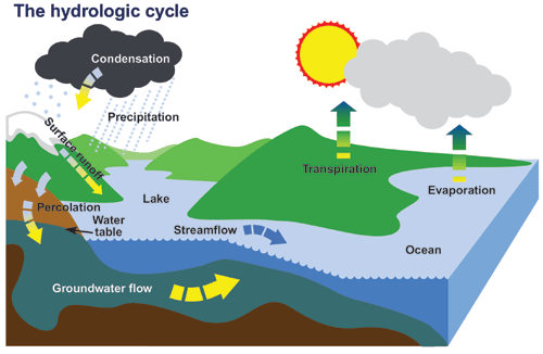
| Hydrological cycle (water cycle) | is the continuous movement of water on the Earth between the land, sea and air. It is powered by the Sun. |
| Evaporation | when water turns into water vapour and rises after heating |
| Condensation | when water vapour turns back into water droplets after cooling |
| Transpiration | water vapour given off by plants |
| Precipitation | water in any form that falls to earth |
| Surface run off | water running over the surface of the earth |
| Groundwater flow | Water that travels underground through rock |
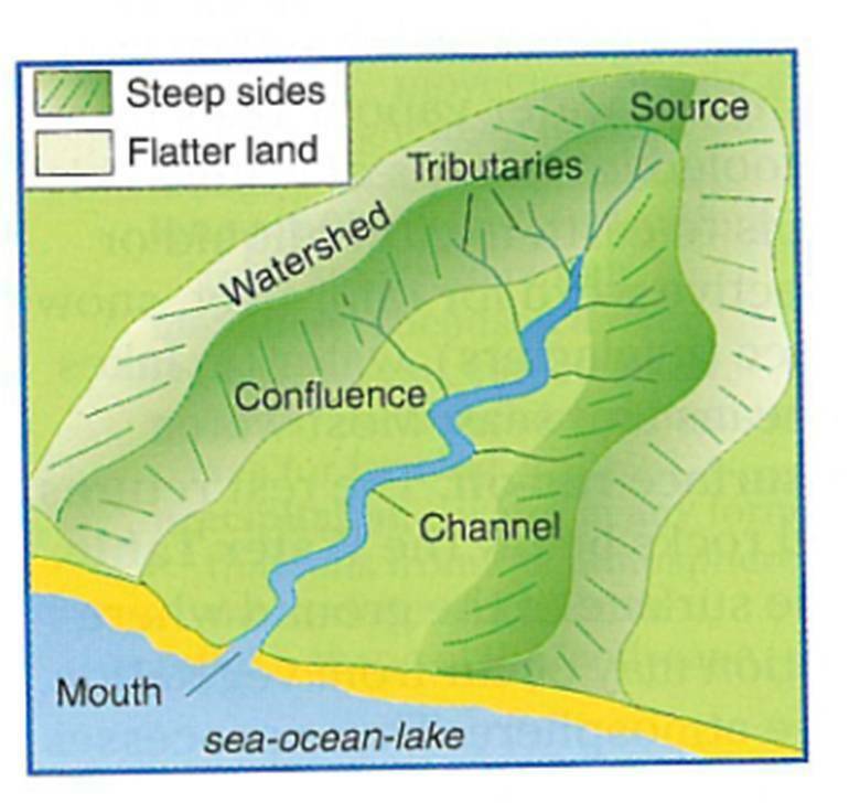
| A drainage or river basin |
is an area of land that is drained by a main river and its tributaries (small rivers joining the main river).
Image:
Riv (image/jpeg)
|
|
Image:
Source (image/jpeg)
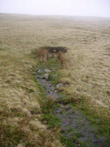
|
River source |
|
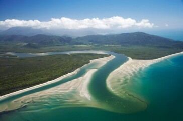
Image:
Mouth (image/jpeg)
|
River mouth |
|
Image:
Download (image/jpeg)
|
Confluence (point where two rivers meet) |
| The drainage basin cycle is an .... system as water can be added or taken away from it, into neighbouring river basins. Look at the diagram of the drainage basin cycle below and check you understand all the new terms on this diagram. | open |
| Aquifier | rock that stores water |
| Interception | when water is stopped from reaching the ground often by plants |
| Stem flow | when water travels down the stem or trunk of a plant |
| Infiltration | when water soaks into the soil surface |
| Percolation | When water moves downwards through underground rocks |
| Through flow | water traveling sideways through soil |
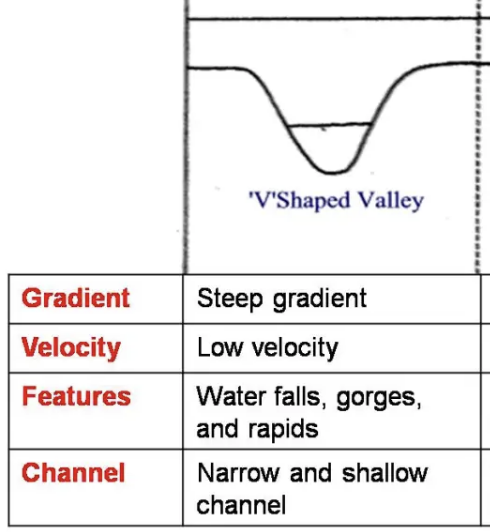
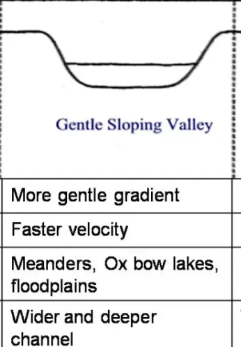
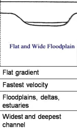
| When you look at the whole course of a river, we call this a | river's long profile |
| upper course (highest velo) | |
| middle course (velo is less than upper) | |
| lower course (velo is low) | |
| Hydraulic action | This process involves the force of water pushing air into the cracks of the beds and banks which forces them apart |
| Abrasion | This is the process by which the bed and banks are worn down by material in the river (load). |
| Attrition | Material (the load) carried by the river bump into each other and so are broken down and smoothed |
| Corrosion | This is the chemical action of river water. The acids in the water slowly dissolve the bed and the banks. |
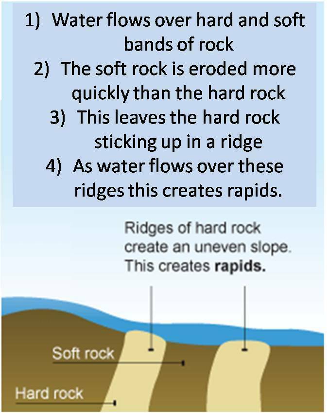
| Rapids |
Image:
Rapids1 (image/jpeg)
|
| Traction | Boulders and pebbles are rolled along the river bed at times of high discharge |
| Saltation | Sand sized particles are bounced along the river bed by the flow of water |
| Suspension | Fine clay and sand particles are carried along within the water even at low discharges |
| Solution | Some minerals dissolve in water such as calcium carbonate. This requires very little energy. |
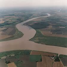
| oxbow lakes | An oxbow lake forms when a meandering river erodes the outer bank of a bend, creating a shortcut. Over time, sediment deposition cuts off the loop, leaving a U-shaped body of water separate from the main channel. |
| how are deltas formed | Deltas are formed at the end of a river, where the river meets the sea at its mouth. As large rivers approach the sea they have the energy to carry large amounts of fine material in suspension. When they reach the sea this slows their velocity and they lose their energy. The fine material is then deposited into the mouth of the river and can block the channel. The river has to divide into a series of smaller channels called distributaries tin order to each the sea. Over time, the deposited material (sand and silt) builds upwards and can break through the river surface to form a delta. Deltas will only form where large amounts of material are carried or the sea is calm. |
| Discharge | the amount of water in a river at any time |
| human causes of flooding in bangladesh | deforesation in bangladesh |
| human causes of flooding in bangladesh | new urban areas |
| human causes of flooding in bangladesh | global warming |
| phsyical causes of flooding in bangladesh | the himalyans are north of bangladesh |
| phsyical causes of flooding in bangladesh | monsoon climate (summer rain) |
| phsyical causes of flooding in bangladesh | floodplain for nearby rivers (ganges) |
| effects of flooding in bangaldesh | -Part of the country ran out of electricity for several weeks -Brings water for growing crops -Railway, roads and bridges were destroyed. (Covered with water) -People suffered from diseases, such as cholera. -Little safe drinking water -Delivery of overseas aid was almost impossible because the airport was under 2 metres of water (1998) -Food shortages caused loss of life, destruction of crops and serious damage to property. -7 million houses were damaged -68% of the country was flooded -Not enough hospital spaces due to diseases -36 million people affected |
| causes of flooding | -Most of the Bangladesh is a floodplain, no more than 6 metres above sea level -Bangladesh has monsoon climate -Heavy rain coincides with that of the highest temperature -Global warming causing the sea level to ride -Deforestation (cutting down trees) causing no interception -Impermeable roads in Dhaka cause more surface run-off |
| floodplains and levees | Floodplains and levees are formed in the middle and lower course of a river Floodplains and leveés are formed by deposition in times of river flood. The river’s load is composed of different sized particles. When a river floods it deposits the heaviest of these particles first. The larger particles, often pebble-sized, form the leveés. Levees are raised banks right next to the river banks. As the water continues to flood futher away from the river banks, the sands are deposited next, then the silts and finally the lightest clays. This build up of sand, silt and clays leads to the formation of a flat piece of land (floodplain) either side of the river- just after the levees. Every time the river floods deposition builds up the floodplain. |
Want to create your own Flashcards for free with GoConqr? Learn more.