Description
|
|
Created by littlecscarfe
almost 11 years ago
|
|
- The Hydrological Cycle
- Inputs
- Precipitation
Annotations:
- precipitation includes all the ways moisture comes out of the atmosphere. precipitation is mainly rain but there are other types e.g. snow, hail and frost
- Precipitation
- Storage
- Interception
Annotations:
- Occurs when some precipitation lands on vegetation or other structures, like buildings and concrete or tarmac surface, before it reaches the soil. Interception creates a significant store of water in the wooded areas. Interception storage is only temporary because the collected water evaporates quickly
- Vegetation
Storage
Annotations:
- occurs when water is absorbed by plants - it is all the water contained in plants at one time
- Channel
Storage
Annotations:
- channel storage is all the water held in a river or stream channel
- Groundwater
Storage
Annotations:
- this is water stored in the ground, either in the soil or in rocks. The waer table is the top surface of the zone of saturation - the zone of soil o rock where all the pores in the soil or rock are fully filled with water. Porous rocks that ca hold water are called aquifers
- Surface
Storage
Annotations:
- This includes water stored in puddles, ponds and lakes
- Interception
- Flows and Processes
- Baseflow
Annotations:
- is groundwater flow that feeds into river banks and beds
- Stemflow
Annotations:
- is water running down a plant stem or tree trunk
- Channel Flow
Annotations:
- is the water flowing in the river or stream itself (also called the river discharge)
- Throughflow
Annotations:
- is water moving slowly downhill through the soil. throughflow is faster through pipes (things like cracks in the soil or animal burrows)
- Percolation
Annotations:
- is water seeping down through soil into the water table
- Groundwater
Flow
Annotations:
- is water flowing slowly below the water table through permeable rock. Water flows slowly through most rocks, but rocks that are highly permeable with lots of joints (gaps that water can get through) can have faster groundwater flow, e.g. limestone
- Infiltration
Annotations:
- is water soaking into the soil. Infiltration rates are influenced by soil type, soil structure and how much water's already in the soil. In a heavy stream, water can't infiltrate fast enough, so it flows over the surface
- Surface Runoff
Annotations:
- is water flowing over the land. it can flow over the whole surface or in little channels. Surface runoff is common in arid areas where torrential rain falls on baked land or in urbanised locations
- Throughfall
Annotations:
- is water dripping from one leaf or plant part to another
- Interflow
Annotations:
- is water flowing downhill through permeable rock above the water table
- Baseflow
- Outputs
- Transpiration
Annotations:
- transpiration is evaporation from plant leaves - plants and trees take up water through their roots and transport it to their leaves where it evaporates into the atomsphere
- Evapotranspiration
Annotations:
- is the process of evaporation and transpiration occuring together - potential evapotranspiration is the amount of water that could be lost by evapotranspiration. Actual evaportranspration is what actually happens. for example, in a desert potential evapotranspiration is high (because heat increases the amount of evaporation) but actual transpiration is low (because there isnt that much moisture in the first place)
- Evaporation
Annotations:
- is water turning into water vapour - turning from a liquid or gas
- Transpiration
- General
Annotations:
- A river's drainage basin is the area surrounding the river where the rain falling on the land lows into the river. this area is also called the rivers catchment The boundary of a drainage basin is the watershed - any precipitation falling beyond the watershed enters a different drainage basin Drainage basins are open systems with inputs and outputs Water comes into the systems as precipitation and leaves via evapouration, transpiration and river discharge
- The Water Balance
Annotations:
- Water balance is worked out from inputs and outputs. The water balance affeccts how much water is stored in the basin. The general water balance in the UK shows seasonal patterns: 1) in wet seasons, precipitation exceeds evapotranspiration. This creates a water surplus. The ground stores fill with water so theres more surface run-off and higher discharge, so river levels rise 2) In drier seasons, precipitation is lower than evapotranspiration. Ground stores are depleted as some water is used (e.g. by plants and humans) and some flows into the river channel, but isn't replaced by precipitation 3) so,at the end of a dry season, there's a deficit (shortage) of water in the ground. The ground stores are recharged in the next wet season (i.e. autumn)
- Inputs
- Flooding
- Management
- Strategies
Annotations:
- Hard engineering is often expensive and disrupts natural processes. Soft engineering tends to be cheaper and requires much less time and money to maintain than hard engineering. Soft engineering is designed to integrate with the natural environment and it creates areas like wetlands, which are important habitats for wildlife. So soft engineering's a more sustainable management strategy than hard engineering because it has a lower
- Hard
Engineering
Annotations:
- Hard-engineering defences are man-made structures that reduce flooding. General disadvantages of hard engineering defences include: 1) They're expensive to build and maintain and need technical skill therefore poorer countries often cannot afford them 2)Floods happen less often, but they can be more hazardous if they do happen, e.g. if a dam breaks then a huge amount of water will rapidly flood the land 3) Natural processes are disrupted, e.g. crops dont get fertile silt from river sediment during low-level flooding 4) They are considered eyesore
- Channel
Straightening
Annotations:
- Channel straightening is where meanders are removed by building artificial cut-throughs. This makes the water flow faster, which reduces flooding because water drains downstream more quickly and doesn't build up to a point where the river channel can't contain it any more. Benefits: It takes less time to navigate the river because it has been made shorter. Disadvantages: Flooding may happen downstream instead, as flood water is carried there faster. More erosion occurs downstream because the river flows faster. Altering river channels disturbs wildlife habitats.
- Diversion
Spillways
Annotations:
- Diversion spillways are channels that take water elsewhere if the water level in the river is too high. Water is normally diverted around an important area or to another river. They prevent flooding because river discharge is reduced. The spillways often have gates that can be opened, so the release of water can be controlled. Disadvantages: An increase in discharge when the diverted water joins another river (or rejoins the same one) could cause flooding below that point. If spillways are overwhelmed, water will flood areas not used to flooding, which could cause even bigger problems.
- Dams
Annotations:
- Dams are huge walls built across rivers. A reservoir is formed behind the dam. Flood water is caught by the dam, which prevents flooding downstream. The water is released as a steady flow throughout the year. Benefits: Turbines are often built into the dams, which generate electricity. Steady water release allows irrigation of land below the dam throughout the year. People can use the reservoir for recreational activities, e.g. sailing Disadvantages: They're very expensive Land is flooded when a reservoir is created. This often destroys farmland and forces people to move elsewhere. They can affect wildlife They trap sediment normally carried in rivers. This can cause the dam to fail. It can also cause increased erosion downstream, as there's less protective sediment being deposited.
- Levees
Annotations:
- Levees are embankments built along rivers. The river can hold more water without overflowing and so it floods less often. Benefits: They allow the floodplain to be built upon. Disadvantages: They're expensive. There is a risk of severe flooding is the levees are breached.
- Soft
Engineering
Annotations:
- Soft engineering defences use knowledge of the whole river basin and its processes, to work with nature. General advantages are: 1) They're cheaper to maintain than hard engineering defences - this is especially important for poorer countries. 2) Flooding is more predictable, reducing the risk of an unexpected diseases 3) They can improve opportunities for recreation, such as fishing. 4) they're considered more attractive than hard engineering schemes
- Alteration of
urban surfaces
Annotations:
- Building porous pavements or soakways increases infiltration, which reduces rapid surface runoff to the river channel. This increases lag time which reduces discharge and flooding. Benefits: Any pollutants in the water are filtered out by the soil before the water reaches the channel. Disadvantages: Its expensive
- Weather
Forecasts
and Flood
Warning
Annotations:
- The Environmental Agency monitors weather forecasts, rainfall, and river discharge. They warn people about possible floods through TV, radio, newspapers and the internet. This means people can evacuate before the flood happens, saving lives. People can also move possessions and use sandbags to help reduce damage if flooding occurs. Disadvantages: Some people might not be able to access the communication network. Flash floods may happen too fast for warnings. People may ignore warnings if they were inaccurate in the past.
- River Restoration
Annotations:
- River restoration involves making the river more natural, e.g. by removing man-made levees. The floodplain can then flood naturally. As the water spreads out over the floodplain the river's discharge is reduced (because less water is in the channel), which reduces flooding downstream. Benefits: Little maintenance is needed, as the river's left in its natural state. The river provides a better habitat for wildlife. Disadvantages: Local flood risk can increase, especially if nothing's done to prevent major flooding.
- Land Use
Management
Annotations:
- Planning restrictions prevent buildings or roads from being constructed on the floodplain. Use of the floodplain is restricted to things like playing fields, allotments or parks. More water can infiltrate so there's less surface runoff, which reduces discharge and flooding. Benefits: There are no new buildings or roads on the floodplain to be damaged, so impact of any flooding is reduced. It provides recreational opportunities e.g. football fields Disadvantages: It restricts development. This is especially where there's a shortage of housing. It cannot be used in areas that are already urbanised
- Wetland and
River Bank
Conservation
Annotations:
- Wetlands store flood water and also slow it down. This reduces flooding downstream. So conserving or re-establishing wetlands gives natural protection from flooding. Planting trees and shrubs along the river bank increases interception and lag time, and reduces discharge. This also decreases flooding. Benefits: Vegetation protects the surface soil from erosion. The vegetation provides habitats for wildlife. Disadvantages: Less land is available for farming
- Case Studies
- HE on the Yangtze
Annotations:
- 1) The Yangtze flows through China. At 6380km long, its the third longest river in the world. 2) Seasonal flooding is common around the Yangtze - China has a rainy season that lasts from about June until August and the huge increase in river discharge during this time often causes flooding. Flooding causes huge problems as theres lots of farmland and major cities next to the river.3) Five major floods have happened over the last century - in 1931, 1935,1949, 1954 and 1998.4) The flood voer 1954 covered 193,000km2 of land and killed 33,169 people. Over 18 million people had to moce. It covered the city of Wuhan for over 3 months.5) The flood in 1998 killed around 3,000 people and made 14 million people homeless.6) Flood protection is mainly done through hard engineering defences.
- Defences
Annotations:
- Dams:There are many dams on the Yangtze river that reduce flooding (46 are planned or under construction currently). The biggest of these is the Three Gorges Dam: 1) Work began on the 101m high structure in 19942)A reservoir is building up behind the dam and catches any flood water, which can then be slowly released over time. The reservoir can store around 22km3 of water.3) Its also the largest hydroelectric power station in the world. the flow of water turns 26 turbines in the dam.4) Locks have been built along side the dam so ships can get passed it. There are many levees along the river. E.g. there are 3600km of levees along the middle and lower parts of the river.
- Effects
Annotations:
- Dam effects: Positive:1) Its thought that the dam had reduced major flooding from once every 10 years, to once every 100 years.2) The turbines in the dam produce a lot of electricity - capacity is likely to reach 22.5 gigawatts (enough to supply about 3% of China's demand).3) The reduction in flooding has made it much safer to navigate up the Yangtze. River shipping has also increased as bigger ships can now travel up the river because the reservoir is deeper than the old river.Negative:1) People have had to relocate as the water level in the reservoir has risen. It's thought that between 1.3 and 2 million people in total will have to relocate by the time its full - 13 cities and 1352 will be submerged. 2) The reservoir will also flood farmland, 657 factories, and 1300 sites of cultural and historic interest. For example, the Templr of Zhang Fei will be submerged.3) A huge amount of sediment is normally carried down the Yangtze river. The dam will trap the sediment which could lead to failure of the dam and cause catastrophic flooding.4) The dam could destroy habitats and endanger species. e.g. fewer than 100 baiji dolphins are left in the Yangtze and the dam is likely to reduce their flood supply. 5) The Three Gorges Dam doesn't protect everyone - rising water levels in the reservoir will increase flooding alonf the tributaries leading to it. The increased water levels in these tributaries will also increase erosion of river banks, causing collapses and landslides. Levee negative effects:1) In 1998 floods many levees broke, which contributed to devastating flooding.2) After this, many levees were reinforced. They were effective at reducing flooding during the 2002 floods but these were much less severe.
- SE in Abingdon
Annotations:
- Soft engineering is used in Abingdon to control flooding:1) Abigdon, a town in South-East England, was built on the floodplains of the River Thames and the River Ock.2) 1500 properties in Abingdon have a 1% chance of flooding in a given year.3) Abingdon has had regular floods over the years - in 1947, 1968, 1977, 1979,1992, 2000 and 2007.4) Intense storms in July 2007 cuased particularlu bad flash floods. The River Thames and Ock burst their banks, flooding 660 properties in Abingdon. Increased surface runoff in built-up areas made the flooding even worse. 5) Hard engineering defences have been considered but have been rejected for various reasons. E.g. a diversion spillways to transport Ock floodwater south of Abingdon was too expensive, and flood barriers to protect properties along the Ock would increase flood risk downstream. Flood protection is mostly done through soft engineering defences.
- Defences
Annotations:
- 1) Gravel soakways have been built along the A34 road.2)Low-value land is allowed to flood, e.g. Tilsley Park sports ground is being considered as an additionaly flood storage area.3) There are planning restrictions on new housing developments built on the Ock floodplain, stating they must have improved drainage systems. 4) Tesco were forced to revise recent permission plans - they had to add drainage improvements scuh as soakways and permeable tarmac5) The Environment Agency's Local FLood Warning Plan warns specific areas at risk and provides a 24 hour floodline.6) There are restrictions on land use, e.g. planning permission was refused for buildings on the Thames floodplain.7) There's detailed advice on the internet about reducing flood damage, e.g. by raising cupboards and using water-resistant plaster.8) Local voluntary flood wardens communicate advice and warnings.9) Improvements have been made to riparian buffers along small rivers. Planting trees reduces the volume of water reaching the Thames and Ock rivers where the flood problem is greater.
- Effects
Annotations:
- 1) Its difficult to measure the success of flood defences because its hard to figure out if any reduction in flooding was because of the success of the defences, or because the weather conditions were less severe. 2) Several flood warnings were issued by the Environment Agency in 2008. 3) The Ock floodplain, which has developments on it, didn't get flooded. However the Thames floodplain did get flooded but its largely clear of development, due to land use management and planning restrictions. 4) The 2008 floods did less damage than in previous years, with minimal cost, little disruption to community services, no lives lost and only a few injuries. However, flooding does still happen in Abingdon.
- HE on the Yangtze
- Strategies
- General
- Causes
- Physical
- Steep Slopes
Annotations:
- Water will reach the river quicker
- Impermeable
Ground
Annotations:
- Clay soils and some rocks, such as granite and shale, are impermeable - they dont allow infiltration of surface water. This increases surface runoff, which increases discharge. If the ground has been baked hard by the heat of the summer, or its frozen, the same thing happens - water can't infiltrate, increasing surface runoff and discharge
- Vegetation
Annotations:
- Sparse vegetation in the drainage basin means little rainfall is intercepted, so more rain reaches the ground. This increases the volume of water reaching the river, which increases discharge. Deciduous trees have no leaves in winter, which has the same effect as sparse vegetation - little rainfall is intercepted.
- Drainage
Density
Annotations:
- Drainage basins with a high drainage density (lots of streams) drain quickly, so have short lag times. Lots of water flows from the streams into the main river in a short space of time, increasing discharge.
- Circular basins
Annotations:
- Water draining into the main river channel will all arrive in a short space of time because all points in the basin are a similar distance from the river. This increases discharge.
- Climate Change
Annotations:
- Climate change could cause an increase in rainfall and more storms in some areas, which could increase flooding.
- Steep Slopes
- Human
- Deforestation
Annotations:
- Clearing trees and plants reduces interception and evapotranspiration. This increases the volume of water that reaches the channel, which increases discharge. Deforestation leaves the soil loose. The soil is eroded by rainwater and carried to the river, which raises the river bed. This reduces the channel capacity, so it takes less water from the river to flood.
- Management Strategies
Annotations:
- Flood management strategies can actually end up making flooding worse. For example, if dams fail they release a huge volume of water all at once - giving a huge increase in discharge and most likely causing a flood.
- Agriculture
Annotations:
- Overgrazing leaves areas with less vegetation, so has the same effect as deforstation. Overgrazing and ploughing also increase soil erosion.
- Urbanisation
Annotations:
- Urban areas have large areas of impermeable tarmac and concrete, so when it rains surface runoff is very rapid. Gutters and drains quickly take runoff to rivers. Both of these things reduce lag time and so increase discharge.
- Deforestation
- Physical
- Case studies
- Pakistan
Annotations:
- •The Pakistan floods began on the 29th July 2010. •Floods occurred as a result of unusually heavy monsoon rains. •1600 deaths •Affected 12 million people in the Punjab and Baluchistan provinces. •Affected 2 million people in the Sindh province. (United Nations Figures)
- Causes
Annotations:
- Physical Causes: 1) Unusually heavy monsoon rains during the normal season thatruns from july to september. Inaugust 2010, more than half of the normal monsoon rain fell in only one week.Typically it is spread over three months. 4 months worth of rainfall in 2 days. In some areas of northern Pakistan received 3 times their annual rainfall in 36 hours.2) Steep sided valley especially within the upper parts of Indus and its tributaries meaning water reaches the river increasingly quickly and adds to the chance of flooding.3) The rainfall in Pakistan caused huge amounts of erosion to rocks which caused a large amount of sediment to be washed into the river channel therefore reducing its capacity and storage thus increasing the extent of the flooding as water reached the floodplain. Human Causes: 1) Highly impermeable surfaces such as drains, sewage systems, tarmac and concrete in cities such as Islamabad means water reaches the river channel more quickly therefore causing flash flooding which happened in Pakistan 2) Deforestation is a large problem within Pakistan and the lack of trees because of this meant a decrease in rate of interception and so more precipitation was able to reach the surface.
- Impacts
Annotations:
- Social:1) 7 million people left homeless and broke2) Many people living in temporary accommodation3) Food shortage were a main concern and caused riots between the public 4) A threat of social unrest occurred due the floods also as families and ethnic groups has to compete with each other in an event of a break down in the government 5) Increase spread and threat of diseases such as malaria, cholera and malnutrition. There was an outbreak of cholera in the flood affect areas through stagnant water. 6) Many people left by the government for many months to fend for themselves without food, water, clothes or shelter especially during winter months.Economic Impacts: 1) Widespread damage to people’s homes. Villages have been completely wiped out 2) Extensive damage to roads, buildings and irrigation works. 3) United Nations estimate of rebuilding the country to its previous state will be billions of dollars. 4) Pakistan’s main industry is agriculture and has been heavily affected by the flood with half a million tonnes of wheat lost and 2 million out of a targeted 14 million bales of cotton have been lost 5) The textile industry accounts for 60% of Pakistan’s exports and as a result export sales have decreased resulting in further poverty occurring in the country Environmental Impacts: 1) 23 % of crops were destroyed. 2) Enormous mudslides took place on steep slopes in mountainous areas. 3) 20% of tree plantations created in the 2009 – 2010 afforestation project were ruined - leaving hill slopes susceptible to erosion, reducing interception of rainfall and increasing the intensity of future floods. 4) Loss of breeding grounds - the floods washed away vital wetland breeding grounds for wading birds and fish. 5) Habitat loss - an estimated 80% of reptile and small mammal habitats were affected within the Swat and Panjorka river catchments. 6) Pollution - a 62000 litres of petroleum and 44300 litres diesel from pumps.
- Cumbria
Annotations:
- The River Eden runs through North Cumbria and reaches the sea near Carlisle. The drainage basin of the River Ede is very large and so it catches a large volume of rainfall, leading to a high river discharge. Some parts of the basin have steep sides so water runs quickly down to the river. There are many streams hat rain quickl into the river, makin the lag time short. On the 8th of January 205, the River Eden flooded Carlisle. The flood return interval of such a large flood is about 200 years.
- Causes
Annotations:
- Physical causes were the main cause:1) There was heavy rainfall on the 6th of Jan for 36 hours. 200mm of rainfall was recorded which is the equivalent of four months of rain.2) Rain fell on saturated ground so the water didn't soak into he ground bu ran straight off into the river.3) This caused a very high peak discharge (over 1520 cumecs) compared to an average discharge of 52 cumecs. Human causes also made the flooding worse:1) Carlisle is a large built-up area, with impermeable concrete and tarmac surfaces and little soil or vegetation. This meant there was little infiltration of rainfall and high surface runoff which increased discharge.2) Drains and sewerage systems overflowed in some areas - becoming a source of flooding themselves. 25% of the flooding problems were associated with overflowing drains.
- Impacts
Annotations:
- Social Impacts:1) 3 people died due to the floods2) Over 3000 people were made homeless for up to a year and thousands of personal possessions were damaged and lost. Living in temporary accomodation disrupted lives in many ways e.g. travel arrangements were disrupted, people were separated and had problems receiving post.3) Children lost out on education as four schools were severly flooded. Newman Catholic School didn't reopen until Easter.4) There was an increase in stress-related illnesses following the floods. Economic impacts:1)It took about a year to repair the damage to home and repairs cost over £100million 2)350 businesses had to shut down as there was no electricity, telephone service or transport. Trade activities from Carlisle railway station were suspended.3)United Biscuits, the largest employer in Carlisle, was flooded with 3m of water that caused over £5 million damage. 33 out of 1100 emplyees lost their jobs.4) 70,000 addresses had no power. The sewage works, police station, fire station and council offices were severly flooded. 5) 80 buses (most of the public transport fleet) were destroyed. Many roads and bridges were damaged e.g. Warwick Road. Environmental Impacts:1)The Flooding increased river bank erosion in some areas.2) Rivers and other habitats were polluted with rubbish and sewage.
- Pakistan
- Impacts
- Social
Annotations:
- 1) People and animals can be killed. 2)Floodwater is often contaminated with sewage, which can lead to a lack of clean drinking water. 3)Contaminated water can also out people at risk of diseases such as diarrhoea 4) Possessions can be damaged by floodwater or lost (washed away). 5) People can be made homeless as their properties are inundated or damaged.
- Environmental
Annotations:
- 1) Floodwater contaminated with sewage and rubbish can pollute rivers. 2) River banks are eroded. Positive impacts include: 3)River sediment is deposited on the floodplain. This makes the land more fertile. 4) Wetlands can be created, e.g. marshes and ponds, which are habitats for many species.
- Economic
Annotations:
- 1) Businesses often have to shut down as premises are inundated and power supplies are affected. 2)Rescue work and repairs are usually costly. Insurance premiums go up after floods. 3)Unemployment levels often rise as businesses shut down because they cannot recover from the flooding. 4) Public transport, roads and bridges can be destroyed 5) Crops can be destroyed. This can lead to a rise in the price of food.
- Social
- Causes
- Management
- River Processes and Channel Characteristics
- The Long Profile
- A long profile shows
you how the gradient
of a river channel
changes from the rivers
source to its mouth by
showing the height of
the river bed above the
base level for the whole
length of the river.
- Upper Course
Annotations:
- In the upper stage, the gradient is steep and the river is high above sea level, which gives it lots of potential energy
- Middle Course
Annotations:
- As the gradient decreases towards the middle stage, potential energy is converted to kinetic energy - the river gains velocity.
- Lower Course
Annotations:
- In the lower stage, the river has little potential energy, but lots of kinetic energy - therefore the river flows faster.
- A long profile shows
you how the gradient
of a river channel
changes from the rivers
source to its mouth by
showing the height of
the river bed above the
base level for the whole
length of the river.
- Characteristics
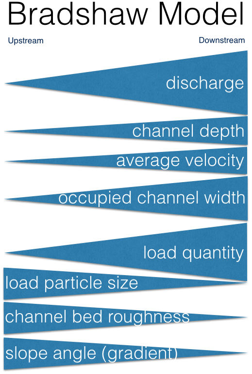
- The Bradshaw model
shows how channel
characteristics
change downstream
- The Bradshaw model
shows how channel
characteristics
change downstream
- Processes
- Erosion
- Abrasion
Annotations:
- eroded pieces of rock in the water scrape and rub against the bed and banks removing material
- Attrition
Annotations:
- the process of rocks smashing into each other and breaking into smaller fragments whilst rounding the edges of the rock
- Solution
Annotations:
- the dissolving of rocks by chemical process, e.g. carbon dioxide dissolves in water to form a weak acid which reacts with rocks like limestone and chalk to break them down
- Hydraulic Action
Annotations:
- the pressure of the water breaks rock particles away from the bed and bank
- Abrasion
- Transportation
- Solution
Annotations:
- substances that can dissolve are carried along in the water. e.g. limestone is dissolved into water that is slightly acidic
- Traction
Annotations:
- very large particles, e.g. boulders are pushed along the river bed by the force of the water
- Saltation
Annotations:
- larger particles such as pebbles or gravel are too heavy to be carried by suspension. Instead the force of the water causes them to bounce along the river bed
- Suspension
Annotations:
- very fine material like silt and clay particles are whipped up by turbulence and carried along in the water
- Solution
- Erosion
- The Long Profile
- River Landforms
- Rejuvenation
Annotations:
- River rejuventation is when a river regains its erosional powers at a point it is unlikely to have them. This can be caused by a fall in sea level (eustatic change) or a fall in level of land (isostatic change)
- River Terraces
Annotations:
- Caused by vertical erosion As water drops down leaves behind ridge where previous floodplain wasCan be symmetrical or asymmetrical
- Knickpoints
Annotations:
- A knick point is a sharp break of slope in the smooth, concave long profile of a river. It is usually marked by the presence of a waterfall (or a series of rapids). At this point vertical erosion associated with rejuvenation is at its greatest. The knick point retreats upstream over time.
- Incised Meanders
Annotations:
- when rejuvenation occurs vertical erosion begins to dominate the lateral erosion that usually occurs in a meander (with erosion on the outside bend). This results in a steep sided meander that is cut into the floodplain. It may become entrenched (symmetrical steep sides on both sides of the river)
- Deposition Landforms
Annotations:
- Landforms caused by fluvial deposition
- Braiding
Annotations:
- Occurs when rivers are carrying a vast amount of eroded sediment If the rivers velocity drops or sediment load becomes too much for the river to carry, sedment is deposited in the channel This causes the river to divide into many small, winding channels that eventually rejoin to form a single channel
- Levees
Annotations:
- Levees are natural, raised embankments formed as a river overflows its banks During a flood, material is deposited across the whole flood pain as the river loses velocity and energy due to increased friction The heaviest material (e.g. sand and gravel) is dropped first, closest to the river channel over time, this material builds up on the river bank, creating a levee
- Floodplains
Annotations:
- When a river overflows its banks and floods the flat land either side of the river (the floodplain), theres an increase in the wetted perimeter and reduction in hydraulic radius This increases friction, reducing the velocity of the river and causing fine silt and sand to be deposited across the floodplain
- Deltas
Annotations:
- when a river reaches the sea (or a lake), the energy of the river is absorbed by the slower moving water of the sea (or lake)This causes the river to deposit its load. These deposits build up on the water bed, until the alluvium (deposited sediment) rises above the sea level, partially blocking the mouth of the river The rver has to braid into several distributaries in order to reach the sea, forming a delta
- Erosion Landforms
- Rapids
Annotations:
- Rapids are relatively steep sections of river with turbulent flow where there are several sections of hard rock and the surrounding soft rock has been eroded to leave these raised sections of rock
- Waterfalls
Annotations:
- waterfalls form where a band of hard rock meets softer rock. the soft rock is eroded more than the harder rock, causing a 'step' in the river bedthe water flowing voer the step speeds up due to the lack of friction as it drops over the step. this increase in speed gives the water greater erosive power, causing further erosion of the soft rock and undercutting of the harder rock as the hard rock is undercut, it can collapse. a deep plunge pool is carved out by abrasion at the foot of the waterfall as the bits of collapsed rock and swirled round the turbulence over time, more undercutting causes more collapse. the waterfall will retreat upstream, leaving behind a steep sided gorge
- Potholes
Annotations:
- Potholes are circular hollows in the river bed that vary in size. They're formed by abrasion as turbulence swirls a rivers bedload in a circular motion within an already occurring depression in the river bed. The erosion caused by the sediment caught in the slight depression creates a hole scraped and rubbed by the rock
- Rapids
- Meanders
Annotations:
- Caused by both erosion and depositionMeanders are large sweeping curves in a river's middle and lower stages They form when alternating pools (deep water) and riffles (shallow water) develop at equally spaced intervals along a stretch of the river because the river channel is deeper in pools its more efficient and has greater energy and more erosive power. Energy is lost as the river flows over riffles due to friction The spacing and distance between riffles and pools causes the river's flow to become uneven and maximum flow to be concentrated on one side of the river turbulence increases in and around the pools as the water sppeds up so the flow of water begins to twist and coil this causes corkscrew-like currents in the river called helicoidal flow, which spiral from bank to bank between pools The helicoidal flow causes more erosion and deepening of the pools, it also causes eroded material to be deposited on the inside of the next bend where the river loses energy the combination of erosion and deposition exaggerates the bend until large meanders are formed, the combined processes also create the meanders' distinctive asymmetric cross-section oxbow lakes are formed when the neck of the loop of a meander is broken through, often during flooding, Deposition dams off the loop, leaving an oxbow lake
- Rejuvenation
Media attachments
Want to create your own Mind Maps for free with GoConqr? Learn more.