4352444
Description
Flashcards by Alisha Osler, updated more than 1 year ago
|
|
Created by Alisha Osler
about 8 years ago
|
|
| Question | Answer |
| What is a Rivers Long Profile? | It shows how the gradient/ steepness changes over the different courses |
| What is a Rivers cross profile? | Shows you the cross section of the river (V-valleys, etc.) |
| What changes the cross section of a river? | 1. Vertical Erosion (deepens channel) 2. Lateral Erosion (widens channel) |
| What are the four processes of erosion? | Hydraulic action (force of water) Abrasion (wearing of banks) Attrition (rocks hitting) Solution (dissolving rock - some) |
| What are the processes of transportation? | Traction (rolling on river bed) Solution (dissolving) Saltation (bouncing) Suspension (carried) |
| What is deposition? | Where the river drops whatever it is carrying |
| Why does deposition happen? | 1. Volume of water falls 2. Amount of eroded material in water increases 3. Water is shallower (meander) 4. River reaches its mouth |
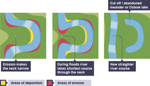
| How are meanders formed? | Meanders occur in the middle valley and are the result of erosion AND deposition processes on a river. In this section of the valley the river erodes laterally and migrates across the valley floor over time, widening the valley. Within the river itself, the fastest current is found on the outside of a bend and the slowest current on the inside of the bend. This is because the depth of the water on the outside of the bend is deeper, so there is less friction and hence higher velocities. Over time, this means that erosion occurs on the outside of meander bends and deposition occurs on the inside. This process can lead to formation of Ox bow lakes. |
| Describe this diagram using key terms | |
| What does "Thalweg" mean? | The line of fastest flow |
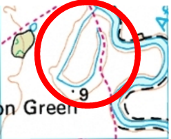
| What does a meander and ox-bow lake look like on a map? | |
| What does a waterfall look like on a map? | |
| Where would you find a waterfall? (source, middle or lower course) | Near the source in the mountains |
| Where would you find a floodplain? (Source, middle or lower course) | In the lower course, where the ground is flattest, and is therefore liable to flood |
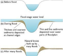
| Describe the formation of a levee | |
| Which landforms occur due to erosion? | 1. Waterfalls and Gorges 2. Meander and Ox-bow lake (both erosion and deposition) |
| Which landforms occur due to deposition? | 1. Levees and floodplains 2. Meanders and ox-bow lake (both erosion and deposition) |
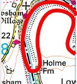
| What does a levee look like on a map? | |
| Where would you find a meander/ox-bow lake? (source, middle or lower course) | Middle course |
| What is the difference between hard and soft engineering? | Hard engineering - doing something to stop floods in the future eg. Dam Soft engineering - doing something to reduce the impact of flooding eg. Flood Warnings |
| What is "Peak discharge" on a flood hydrograph? | The highest amount of water in the river at that period of time |
| What is the "Lag time" on a flood hydrograph? | The delay between peak rainfall and peak discharge A.K.A the amount of time it takes for most of the water to go into the river |
| What is the "Rising limb" on a flood hydrograph? | The increase in river discharge as rainwater flows into the river |
| What is the "falling limb" on a flood hydrograph? | The decrease in river discharge as the river returns to its normal level. |
| How does Afforestation affect a rivers discharge? | Afforestation means planting trees. More trees mean there are more roots to soak up excess water, therefore less water gets to the river, so lower peak discharge. |
| How does Urbanisation affect a rivers discharge? | Urbanisation means people living in cities. Cities mean roads and other impermeable rock. These rocks won't soak up the water, so there is more water on the surface which means a higher peak discharge as it all goes into the river. |
Want to create your own Flashcards for free with GoConqr? Learn more.