9023951
Description

Flashcards by Natalia Cliff, updated more than 1 year ago
|
|
Created by Natalia Cliff
almost 7 years ago
|
|
| Question | Answer |
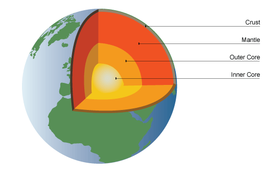
| The structure of the earth |
Image:
Structure (image/gif)
|
| Convection currents | the circular current of heat in the mantle |
| Oceanic Crust | -Newer (less than 200 million years) -Denser -Can sink -Can be destroyed and renewed |
| Continental Crust | -Old (older than 1500 million years) -Cannot sink -Less dense -Cannot be destroyed or renewed |
| 4 types of plate margins | -Destructive plate margin -Constructive plate margin -Conservative plate margin -Collision plate margin |
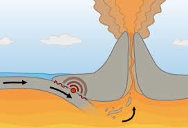
| Destructive plate margin diagram |
Image:
Destructive (image/jpeg)
|
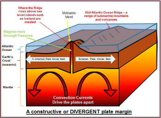
| Constructive plate margin diagram |
Image:
Constructive (image/png)
|
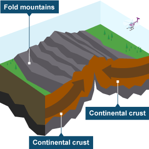
| Collision plate margin diagram |
Image:
Collision (image/png)
|
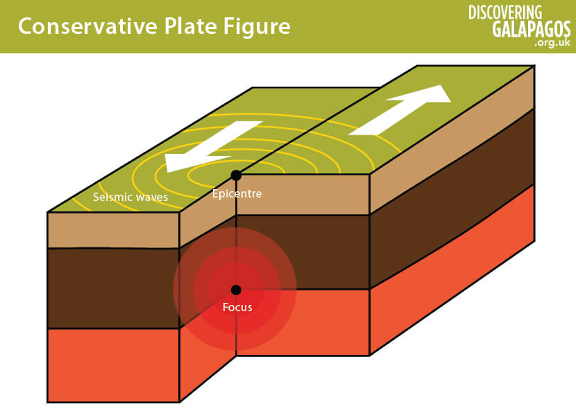
| Constructive plate margin diagram |
Image:
Conservative (image/png)
|
| Fold mountains | -New fold mountains include the Andes and Himalayas -Older ranges like those in Cumbria have been weathered down |
| Ocean trenches | The deepest parts of the oceans |
| Formation of fold mountains and ocean trenches | -Fold mountains alone are formed at collision plate boundaries -Fold mountains and ocean trenches are formed at destructive plate boundaries -Sediment is deposited in layers over time -The plates moving next to each other pushes the sediment together, where it crumples into anticlines and synclines -If destructive, the submerging oceanic plates leaves a deep ocean trench behind |
| Andes What is it used for? | -Farming -Hydroelectric power -Tourism -Mining |
| Andes Farming | -Subsistence farmers in Bolivia -Farm on terraces that trap water and limit the downward movement of soil -Lamas are pack animals that can manage the terrain and carry 25% of their weight -Females farmed for meat, milk and wool |
| Andes Mining | -Peru and Bolivia top 10 for tin -Columbia has a l0t of nickel -Peru has a lot of gold -Half of Peru's export is from mining -Yanacocha gold mines are the largest in the world |
| Andes Hydroelectric power | -Steep slopes and narrow valleys are useful -Melting snow provides a lot of water, but variation throughput the year is a problem -2009 El Platanal power plant began to provide energy for Peru |
| Andes Tourism | -Natural attractions like mountain peaks, volcanoes, glaciers and lakes -Inca Trail, especially Machu Picchu in Peru |
| Nyiragonga The Eruption | -17 January 2002 Nyiragonga volcano in Democratic Republic of Congo was disrupted by plate movement in the African rift valley -Lava spilled sideways in 3 streams -Lava reached a speed of 60 km/h |
| Nyiragonga Primary effects | -Lava flowed over runways in Goma airport -Lava split the town in half -Destroyed homes, roads and water pipes -Started explosions in fuel stores and power plants -Killed 45 people |
| Nyiragonga Secondary effects | -Half a million people fled Goma into neighbouring Rwanda -Slept on the streets of Gisenyi -No shelter, electricity or clean water so couldn't cope -High risk of cholera -Looting occurred in Goma -People scared to return to Goma |
| Nyiragonga Response | -Water supplied in tankers -Christian Aid and Oxfam distributed food, medicine and blankets |
| Great Mountain Glacier, Iceland 2010 Location and eruption | -Iceland lies on the Mid-Atlantic ridge (constructive margin between Eurasian plate and North American) - March 2010 2 months of lava eruptions that were little threat -14th April a lot of ash was launched into the air |
| Great Mountain Glacier, Iceland 2010 Local impact and response | -Heavier particles of ash fell to the ground close to the volcano -Hundreds were evacuated -Glacier melted so flooding was an issue -Breached embankments to allow water to flow into the sea -Protected expensive bridges and embankments repaired within a few weeks |
| Great Mountain Glacier, Iceland 2010 International impact and response | -Mid-April fine ash cloud spread over western Europe -Western Europe airspace shut down due to fear of the effect of ash on the Jet engines -Business people and Tourists left stranded -Industrial production affected as raw material couldn't be flown -Kenyan farm workers lost jobs as fresh produce couldn't be flown to Europe |
| Great Mountain Glacier Positive effects | -Tourism to Iceland "The land of ice and fire" -Ash is rich in nutrients so good for farms -Sulphur can be found in volcanic crater for bleaching sugar, making matches and fertiliser -Small quantities of copper, gold, silver, lead and zinc are found in volcanic regions |
| Composite Volcano | -Steep slope, narrow base -Alternating layers of lava and ash -Have side vents -Explosive -Have a magma chamber -Destructive or collision boundaries |
| Shield Volcano | -Gently sloping sides -Very wide base -Formed by frequent, gentle eruptions of basaltic lava -Magma chamber -Formed at constructive boundaries |
| Predicting volcanoes | Measuring the: -Bulge -Gases -Earthquakes -Minor eruptions |
| Measuring the bulge | -A volcano bulging can indicate a rise of magma -Can place a tiltmeter on the volcano -Or use two laser points, satellites can pick up if the two points have moved a mm apart |
| Measuring Earthquakes | -Increase of earthquakes could mean magma is rising underneath the surface -Earthquakes can be measured using seismometers |
| Monitoring minor eruptions | -Digital cameras can be set up on the edge of a crater, allowing scientists to monitor them from a safe distance |
| Monitoring Gases | -Increase in percentage of Sulphur dioxide from gases emitted by a volcano can indicate that it is about to erupt |
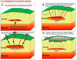
| Supervolcano | -Much larger than normal volcanoes -emit at least 1000 km3 of material, compared to Mt St Helens 1 km3 -Have large depressions called calderas rather than a cone shape |
| Formation of a Supervolcano | -Magma rises and creates a large bulge -Ash and gases escape through fissures -Magma chamber collapses forming a depression called a caldera |
| Formation of a Supervolcano diagram |
Image:
Supervolcano (image/jpeg)
|
| Yellowstone Size | -Magma chamber is 80 km by 40 km by 8 km -Eruptions 2 mill, 1.3 mill and 630 000 years ago |
| Yellowstone Potential effects | -Would destroy 10 000 km2 of land -kill 87 000 people -15 cm of ash in 1 000 km radius, killing 1 in 3 affected -Global dimming caused by ash would cause crops to fail |
| Characteristics of an earthquake | -Focus is the point in the earths crust where the earthquake begins -Epicentre is the point directly above the focus on the crusts surface -Radiating out from the focus are seismic waves that cause the ground to shake |
| Measuring Earthquakes | Richter scale: -10-fold increase every time the scale increases by one -Measures the strength of an earthquake with a siesmometer on a seismograph Mercalli scale - measures effect of an earthquake from I to XII -Subjective |
| Where do Earthquakes occur? | -Destructive margins -Constructive margins -Conservative margins |
| Earthquakes at destructive margins | Pressure from subduction can cause strong earthquakes as it is periodically released |
| Earthquakes at constructive margins | Less severe earthquakes as pressure from plates moving apart is less intense |
| Earthquakes at conservative margins | Plates stick as they slide past each other causing pressure build up. This pressure is released suddenly often resulting in a powerful earthquake |
| Kobe Causes | -5:46 17 Jan 1995 Philippines plate shifted under the Eurasian plate -seismic waves travelled along the Nojima fault line under Kobe -7.2 on the Richter scale -Tremors lasted 20 seconds |
| Kobe Effects | -6434 people dies -Over 4000 seriously injured -300 000 homeless -Gas mains ruptured and water pipes cracked -Railway lines buckled and sections of elevated roads collapsed -2 mill without electricity and 1 mill without water for a week -Fire due to ruptured gas mains, couldn't be put out due to water pipes cracking and damaged roads -Damage in excess of £220 bn |
| Kobe Response | -Friends and neighbours searched through the rubble,helped by emergency services when access was possible -Hospitals operated in corridors -7-eleven helped provide essentials -80% of railways operational within a month -80% of port operational within a year, but most of the trade gone -Building regulations changed |
| Haiti Causes | -12 January 2010 -Stress build up between conservative boundary of north american and Caribbean plates -7.0 on the Richter scale -15 km south west of Port-au-Prince -following minor tremors of 5.0 |
| Haiti Effects | -230 000 people killed -2 million affected -1.5 million homeless -180 000 homes destroyed -Homeless put in 1100 temporary camps where hundreds died from cholera -19 million cubic meters of rubble -5000 schools damaged -Electricity, water, sanitation and communications destroyed or badly disrupted -$US 11.5 bn damage |
| Haiti Response | -Search and rescue teams with trained medics, sniffer dogs and heat sensing equipment flown in -Food, water and medicine flown in from USA and Dominican Republic -UN and USA provided security to maintain law and order -UK charity raised over £100 m which supported 1.2 m people -3/4 damaged buildings assessed and repaired -200 000 people received cash/food for clearing rubble -World Bank pledged $US 100 m |
| Haiti Why was it so badly affected? | -Very poor so unprepared and couldn't cope -80% of people lived in poorly constructed buildings that just collapsed -Earthquake very close with a shallow focus -Port destroyed and airport damaged making it hard to get emergency supplies -Lack of stable government caused chaos -Lack of doctors, hospitals (destroyed) and medicine |
| 3 P's | -Prediction -Preparation -Protection |
| Prediction | -Very hard to do -Know where but hard to say when -Haichen (China) evacuated 1 mill people due to unexplained animal behaviour -West sceptical of animal behaviour |
| Protection | -Appropriate building standard -Following building reguations |
| Preparation | Hospitals, emergency services and inhabitants practise with drills so people know what to do to increase their chance of survival |
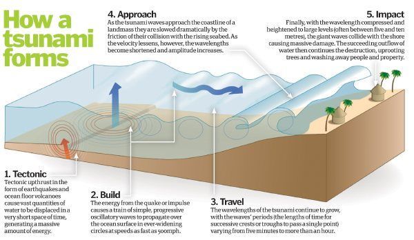
| Tsunamis VS normal waves | -Normal waves are 100 m crest to crest but tsunamis are 200 km -normal wave is 2 m high, tsunami is 1 m high -Tsunamis approach almost unnoticed at 800 km/h -As they near land they reduce in length but gain in height |
| Formation of a Tsunami | -Slip in the margin displaces water -Wave splits -Half travels towards land, the other half out to sea |
| Formation of a Tsunami diagram |
Image:
Tsunami (image/jpeg)
|
| Tohoku Causes | -Pacific plate subducting under north american plate -200 km of rock slipped under causing an upward flick of 5-10 m -This triggered the Tsunami |
| Tohoku The Tsunami | -11 March 2011 -9.0 on the Richter scale -100 km east of Sendai -In 30 min 40 m high wave hit Sendai -9 additional waves 10 m high -3000 km coastline affected -Water went 10 km upshore |
| Tohoku Effects | -20 000 people killed -500 km2 coastal plane inundated -Sendai (port city of 100 000) virtually destroyed -200 000 buildings destroyed -Ruptured gas pipes led to fires that continued for days -Explosions at Fukushima power plant as tsunami over-topped defences -6 mill homes without electricity 1 mill people without water -Heavy snow, roadblocks from debris and landslides |
| Tohoku Response | -100 000 soldiers distributed food and blankets and helped in search and rescue -Exclusion zone around Fukushima -Huge reconstruction programme planned -New Tsunami defences to be over the standard 12 m |
Want to create your own Flashcards for free with GoConqr? Learn more.