11311348
Description

Mind Map by Lily Duffy, updated more than 1 year ago
|
|
Created by Lily Duffy
over 6 years ago
|
|
Coastal environment:
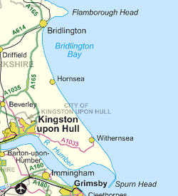
The Holderness Coast
- Where is it?
- The Holderness coastline is 61km
long- it stretches from Flamborough
Head to Spurn Head
- Most of the cliffs are made
of till (boulder clay) and the
coast is exposed to powerful
destructive waves from the
North Sea during storms
- The Holderness coastline is 61km
long- it stretches from Flamborough
Head to Spurn Head
- What are the factors
affecting the coastal
system? Why is it
eroding so rapidly?
- Erosion- the soft boulder clay is
easily eroded by wave act. In
some places, e.g. Great Cowden,
the rate of erosion has been over
10m/year
- Mass movement- the boulder clay is also prone
to slumping when its wet. Water makes the
clay heavier and acts as a lubricant between
particles, which makes it unstable
- Transportation- prevailing winds from the
northeast transport material southwards.
These winds also create an ocean current,
which transports material south by longshore
drift. Rapid erosion means there is always
plenty of sediment to be transported
- Deposition- where the ocean current
meets the outflow of the Humber River,
the flow becomes turbulent and
sediment is deposited
- Erosion- the soft boulder clay is
easily eroded by wave act. In
some places, e.g. Great Cowden,
the rate of erosion has been over
10m/year
- What are the coastal
processes that have
shaped the coast?
- Headland and wave-cut platforms- to
the north of the area, the boulder clay
overlies chalk. The chalk is harder and
less easily eroded, so it has formed a
headland (Flamborough Head) and
wave-cut platforms, such as those
near Sewerby. Flamborough Headhas
features such as stacks, caves and
arches
- Slumping cliffs- frequent slumps give
the boulder clay cliffs a distinctive
shape. In some locations several
slumps have occurred and not yet
been eroded, making the cliff tiered.
For example, slumps are common
around Atwick Sands
- Beaches- the area to the
south of Flamborough Head
is sheltered from wind and
waves, and a wide sand and
pebble beach has formed
near Bridlington
- Sand dunes- around
Spurn Head, material
transported by the wind
is deposited, forming
sand dunes
- Spit- erosion and longshore drift have created a spit
with a recurved end across the mouth of the Humber
Estuary- this is called Spurn Head. To the landward
side of the spit, estuarine mudflats and salt marches
have formed
- Headland and wave-cut platforms- to
the north of the area, the boulder clay
overlies chalk. The chalk is harder and
less easily eroded, so it has formed a
headland (Flamborough Head) and
wave-cut platforms, such as those
near Sewerby. Flamborough Headhas
features such as stacks, caves and
arches
- Why does the coastline
need to be managed?
- The Holderness coastline has
retreated by around 4km over
the past 2000 years. Around
30 villages have been lost
- Ongoing erosion could
cause numerous
social, economic and
environmental
problems such as:
- Loss of settlements and
livelihoods- e.g. the
village of Skips is at risk
and 80 000m squared of
good quality farmland
is lost each year on the
Holderness Coast
- Loss of infrastructure-
the gas terminal at
Easington is only 25m
from the cliff edge
- Loss of Sites of Special
Scientific Interest (SSSIs)-
e.g. the Lagoons near
Easington provide
habitats for birds
- Loss of settlements and
livelihoods- e.g. the
village of Skips is at risk
and 80 000m squared of
good quality farmland
is lost each year on the
Holderness Coast
- The Holderness coastline has
retreated by around 4km over
the past 2000 years. Around
30 villages have been lost
- What management
strategies have been
put in place?
- A total of 11.4km of the 61km
coastline is currently
protected by hard engineering
- Bridlington is protected by a 4.7km
long sea wall as well as timber
groynes
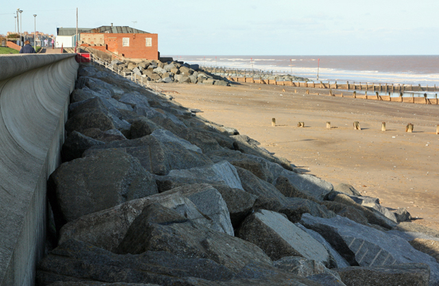
- There's a concrete sea
wall, timber groynes
and riprap at Hornsea
that protect the village
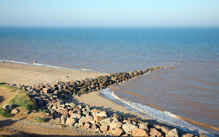
- Two rock groynes and a 500m long
revetment were built at Mappleton in
1991. They cost £2 million and were
built to protect the village and the
B1242 coastal road
- A landowner in Skipsea
has used gabions to
help protect his
caravan park
- There are groynes and a sea wall at
Withernsea. Some riprap was also
placed in front of the all after it was
damaged in severe storms in 1992
- Easington
Gas terminal
is protected
by a
revetment
- The eastern side
of Spurn Head is
protected by
groynes and
riprap
- A total of 11.4km of the 61km
coastline is currently
protected by hard engineering
- Why are these
not
sustainable?
- The groynes trap sediment, increasing the width of the beaches.
This protects the local area but increases erosion of the cliffs
down-drift (as the material eroded from the beaches there isn't
replenished). E.g.the Mappleton scheme has caused increased
erosion of the cliffs south of Mappleton. Cowden Farm, just
south of Mappleton, is now at risk of falling into the sea
- The sediment produced from the erosion of the Holderness
coastline is normally washed into the Humber Estuary(where it
helps to form tidal mudflats) and down the Lincolnshire coast.
Reduction in this sediment increases the risk of flooding along
the Humber Estuary, and increases erosion along the
Lincolnshire coast
- All these
problems make
the existing
schemes
unsustainable
- The protection of local areas is leading to the
formation of bays between those areas. As
bays develop the wave pressure on
headlands will increase and eventually the
coast of maintaining the sea defences may
become to high
- The groynes trap sediment, increasing the width of the beaches.
This protects the local area but increases erosion of the cliffs
down-drift (as the material eroded from the beaches there isn't
replenished). E.g.the Mappleton scheme has caused increased
erosion of the cliffs south of Mappleton. Cowden Farm, just
south of Mappleton, is now at risk of falling into the sea
- What are the future
challenges?
- The SMP for Holderness for the next 50 years recommends
'holding the line' at some settlements (e.g at Bridlington,
Withernsea, Hornsea, Mappleton and Easington Gas Terminal)
and 'doing nothing' along less-populated stretches. However,
this is unpopular with owners of land or property along the
stretches where nothing is being done
- Easington Gas Terminal is currently protected by rock
revetments, and the SMP recommends that these defences
are maintained for as long as the gas terminal is operating.
However, the defences only span about 1km in front of the
gas terminal, meaning that the village of Easington (with a
population of about 700 people) isn't protected. The defences
may also increase erosion at legally-protected Sites of Special
Scientific Interest (SSSIs) to the south
- Managed realignment has been
suggested e.g. relocating caravan parks
further inland. This would be a more
sustainable scheme as it would allow
the coast to erode as normal without
endangering businesses.However,
there are issues surrounding how
much compensation businesses will get
for relocating. Also relocation isn't
always possible
- In 1995, Holderness Borough Council decided to stop trying to protect Spurn
Head from erosion and overfishing- do nothing became the new strategy.
This saves money and allows the spit to function naturally, but over washing
may damage marsh environments behind the spit. A coastguard station on
the spit may also be at risk
- The SMP for Holderness for the next 50 years recommends
'holding the line' at some settlements (e.g at Bridlington,
Withernsea, Hornsea, Mappleton and Easington Gas Terminal)
and 'doing nothing' along less-populated stretches. However,
this is unpopular with owners of land or property along the
stretches where nothing is being done
Media attachments
Want to create your own Mind Maps for free with GoConqr? Learn more.