4216517
Description
Mind Map by Faiza Hassan, updated more than 1 year ago
|
|
Created by Faiza Hassan
about 10 years ago
|
|
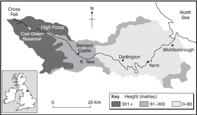
River Tees
- Location
- The source of this river is Cross Fell
and the ending of the river is in the
North sea. Its Located in the North East
of the UK and the river flows through
many places such as: Darlington and
Barnard Castle.
- The source of this river is Cross Fell
and the ending of the river is in the
North sea. Its Located in the North East
of the UK and the river flows through
many places such as: Darlington and
Barnard Castle.
- Upper Course
- The upper course is found in the high lands and
flows through V-Shaped Valley's. It is very
powerful in its flow due to the erosion. It flows
600m above Sea level cutting through waterfalls
such as: Cauldron Snout
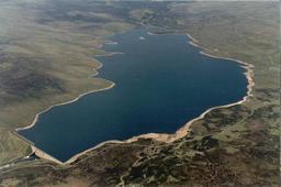
- Cauldron Snout (Water Fall): This is near
Cow Green reservoir. This waterfall is 200
Yards long. This is the longest waterfall in
the UK
- Cross Fell (Source): Up in
the empty Mulan Hills was a
highland 600 m above sea
level was an average of
1200 ml of rain per year.
- Cauldron Snout (Water Fall): This is near
Cow Green reservoir. This waterfall is 200
Yards long. This is the longest waterfall in
the UK
- The upper course is found in the high lands and
flows through V-Shaped Valley's. It is very
powerful in its flow due to the erosion. It flows
600m above Sea level cutting through waterfalls
such as: Cauldron Snout
- Middle Course
- Flood plains on each side are 10cm and tend
to be quite wide. Waterfalls are most likely
found here such as: High Force
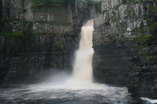
- High Force ( Waterfall ): The river flows over a band of hard
and soft rock. Then the river erodes the soft rock faster than
the hard rock. Therefore the soft rock is eroded to form a
plunge pool and then moves to form an unsupported hard rock
step . The unsupported hard rock then falls apart and the
waterfall all ,moves backwards creating a gorge. The names of
the hard rock (Whinsill) and soft rock (Limestone and
Sandstone). The sft rock is very soft and breaks quite easily and
dissolves much easier than the hard rock. This is now known as
a tourist attraction.
- Flood plains on each side are 10cm and tend
to be quite wide. Waterfalls are most likely
found here such as: High Force
- Lower Course
- The Lower Course is very flat,
tidal and flows into the north sea
- Yarm ( Meander ): This town is on
the meander bend. This has a big
water supply and has made a great
defensive site however this took a
very long time
- Seal Sands (Tidal Estuary):
This is flat land which is
quite tidal and deposits
drained mud. Then it
became flat land, large and
quite deep also the water
became polluted.
- Seal Sands (Tidal Estuary):
This is flat land which is
quite tidal and deposits
drained mud. Then it
became flat land, large and
quite deep also the water
became polluted.
- Stockton (Human interaction): This
is made up of cut off meanders that
have been used to control flooding
and tees barrage
- Yarm ( Meander ): This town is on
the meander bend. This has a big
water supply and has made a great
defensive site however this took a
very long time
- The Lower Course is very flat,
tidal and flows into the north sea
Media attachments
Want to create your own Mind Maps for free with GoConqr? Learn more.