7504260
Description

Mind Map by Isobel Temple, updated more than 1 year ago
|
|
Created by Isobel Temple
about 7 years ago
|
|
Geography:Landscapesof the UK (general)
- Knowing the UK
- UK=Scotland, England, Wales, Northen Ireland
- Geology effects the landscape because it means rock errodes at different rates
- Soil effects the landscape because if it is good soil there will be lots of farming
- British Isles= Scotland, England, Wales, Ireland, Northen ireland
- British Isles= Scotland, England, Wales, Ireland, Northen ireland
- Soil effects the landscape because if it is good soil there will be lots of farming
- Geology effects the landscape because it means rock errodes at different rates
- GB= Scotland, England, Wales
- UK=Scotland, England, Wales, Northen Ireland
- Rock types
- Metamorphic rock
- 1. Form when sedimentary or igneous rocks go under great heat or pressure below the earths surface causing them to change
- 2.They type depends on what it was formed from.
- 2.They type depends on what it was formed from.
- 1. Form when sedimentary or igneous rocks go under great heat or pressure below the earths surface causing them to change
- Sedimentary rock
- 2.They are mostly formed underwater
- 1.They form when rock particles are worn off by other rocks or the skelrton of other creatures
- 1.They form when rock particles are worn off by other rocks or the skelrton of other creatures
- 3.The wearing away of these rocks are called weathering
- 4.The particles are carries away by wind or water. Eventually they settle out to form layers called strata.
- 2.They are mostly formed underwater
- Igneous rock
- 1. It is formed from magma either underground (intrusive) or erupted from from a volcano to the earths surface (extrusive)
- 2.When it cools below earth it cools slowly to form large crystals
- 3.When it cools on the surface it does it very quick to form tiny crystals
- 3.When it cools on the surface it does it very quick to form tiny crystals
- 2.When it cools below earth it cools slowly to form large crystals
- 1. It is formed from magma either underground (intrusive) or erupted from from a volcano to the earths surface (extrusive)
- Metamorphic rock
- UK landscapes
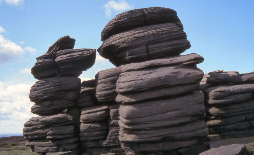
- Upland (Bodmin moor)
- It is quite cold and very windy
- Can have dramatic peaks and ridges with weathered rocks or moorlands with heather
- Granite is igneous extrusive rock
- Granite is igneous extrusive rock
- It is in the center of cornwall.
- It is used for tourism and to graze sheep
- It is 25km (diameter) exposure of granite in the middle of Cornwall
- It has tors
- It has tors
- It is 25km (diameter) exposure of granite in the middle of Cornwall
- Can have dramatic peaks and ridges with weathered rocks or moorlands with heather
- It is quite cold and very windy
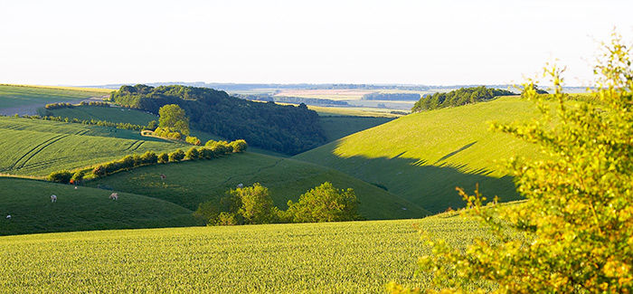
- Low land (Yorkshire Wolds)
- They are usally flatter than the otehr landscapes in the UK they are often found in centeral/ southern england
- It is in north yorkshire, west of Scarbrough and Bridlington
- Used for farming
- It is the warmest
- It is the warmest
- It is very rural and exposed which means it is windy
- Made of chalk
- Means the land is rich which means it is farmable
- Means the land is rich which means it is farmable
- Made of chalk
- They are usally flatter than the otehr landscapes in the UK they are often found in centeral/ southern england
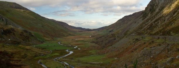
- Glaciated (Nant Francon)
- In the north of wales in Snowdonia
- It has 'U' shaped vallies
- Used for sheep grazing and tourism (walking)
- It is made of Limestone
- It is very cold which means freeze thaw happens
- It is made of Limestone
- In the north of wales in Snowdonia
- Upland (Bodmin moor)
- Human Activity
- Street lighting: It improves saftey, reduces crime but cause light pollution
- Traffic infrastructure: moterways ,dual carriageways- create noise and are barries for wildlife
- Pedestrianisation: reduces accidents and improves the area, could increase trees
- Pedestrianisation: reduces accidents and improves the area, could increase trees
- Traffic infrastructure: moterways ,dual carriageways- create noise and are barries for wildlife
- Construction activity and high rise development, golf courses
- Solar farms: may result in loss of wildlife, change nature of surface drainiage
- Street lighting: It improves saftey, reduces crime but cause light pollution
- Erosion
- Attrition: This is the process of rocks hitting each other and breaking into smaller rocks
- Hydraulic action:This is the forces of the water hitting the banks and beds
- Corasion / chemical erosion: a change in the waters ph causing bits to break away
- Abrasion:This is the force of bits of rock in the water blasting into the channel (sandpaper)
- Abrasion:This is the force of bits of rock in the water blasting into the channel (sandpaper)
- Corasion / chemical erosion: a change in the waters ph causing bits to break away
- Hydraulic action:This is the forces of the water hitting the banks and beds
- Attrition: This is the process of rocks hitting each other and breaking into smaller rocks
- Transportation
- Solution: Minerals are dissolved in the water and carried along in a 'solution'
- Suspension: Fine material is carried in the river, this makes water look murky
- Saltation: Small pebbles and stones bounce along the river bed
- Traction: Bed-load (big boulders) are slowly rolled along the river bed
- Traction: Bed-load (big boulders) are slowly rolled along the river bed
- Saltation: Small pebbles and stones bounce along the river bed
- Suspension: Fine material is carried in the river, this makes water look murky
- Solution: Minerals are dissolved in the water and carried along in a 'solution'
- Weathering
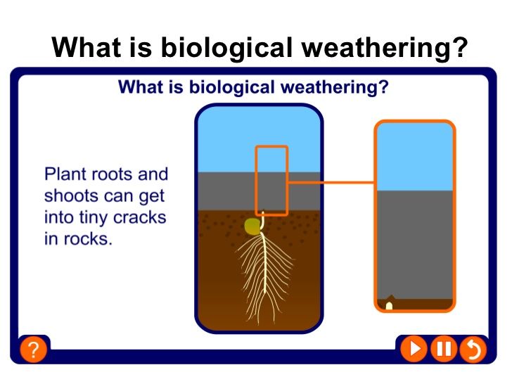
- There are 3 types: Physical, Biological, Chemical
- Biological weathering:Acid from animal waste can contribute but mainly seeds in soil growing cause a crack in a rock and eventually push throught the rock
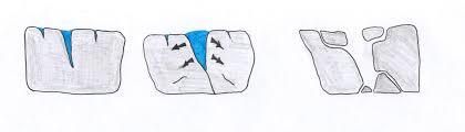
- Freeze-thaw weathering: (Physical)It rains and the water gets into a crack. it freezes, this cause more cracks. When it melts again the water gets into those cracks and cause new cracks. Thsi happens a lot then the rock breaks.
- Freeze-thaw weathering: (Physical)It rains and the water gets into a crack. it freezes, this cause more cracks. When it melts again the water gets into those cracks and cause new cracks. Thsi happens a lot then the rock breaks.
- Exfoliation (Onion-Skin):A rock is heated up by the sun, it expands. At night it cools and shrinks.It repeates untill the rock has layers and flakes off
- Chemical: Can be slow or fast. In slow the acid rain (only an example) is not that strong so takes longer, in rapid it is stronger
- There are 3 types: Physical, Biological, Chemical
- Mass movement
- It is the movement of rock material downslope due to gravity
- Mudflow: On steep slopes, after a long peripd of heavy rainfall soil becomes saturated so mud and weak rock flows quickly downslope
- Rock fall: Blocks of rocks slide down hill due to a lot of weathering. Spontaneous sliding of many large rocks could caused by extream chemical weathering
- Slumping (rotational slip): Wjen permeable rock (like sandstone) lies over impermeable rock (like granite). The permeable rock may become saturated (due to heavy precipitation). The rock then falls down a curved slope and turns as it falls.
- Land slide: Rocks which have joints and cracks in line up with the slope which they lie on fall downwards in big groups together.
- Land slide: Rocks which have joints and cracks in line up with the slope which they lie on fall downwards in big groups together.
- Slumping (rotational slip): Wjen permeable rock (like sandstone) lies over impermeable rock (like granite). The permeable rock may become saturated (due to heavy precipitation). The rock then falls down a curved slope and turns as it falls.
- Rock fall: Blocks of rocks slide down hill due to a lot of weathering. Spontaneous sliding of many large rocks could caused by extream chemical weathering
- Mudflow: On steep slopes, after a long peripd of heavy rainfall soil becomes saturated so mud and weak rock flows quickly downslope
- It is the movement of rock material downslope due to gravity
Media attachments
Want to create your own Mind Maps for free with GoConqr? Learn more.