7504317
Description

Mind Map by Isobel Temple, updated more than 1 year ago
|
|
Created by Isobel Temple
almost 9 years ago
|
|
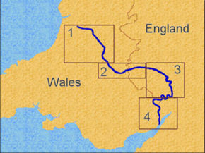
Case study: River Wye
- Location/
journey
- Source:
Plynlimon
hill range in
wales
- From there it
goes south
then SE
passing
Hay-On-Way
- After it turns E and
crosses the boarder into
England
- It passes near Hereford
the turns180 and goes
SW back into Wales.
- Does a little bump the follows the
boarder (directly S) past chepstow
to the mout and exits into Bristol
Channel
- Does a little bump the follows the
boarder (directly S) past chepstow
to the mout and exits into Bristol
Channel
- It passes near Hereford
the turns180 and goes
SW back into Wales.
- After it turns E and
crosses the boarder into
England
- Source:
Plynlimon
hill range in
wales
- 5 Fast facts
- 210Km
(150 miles)
long
- 5th longest
river in the Uk
- One of the
highest rain falls
in the UK
- Ends near Chepstow
and exits into the
Bristol channel
- At the end of the river it
has the2nd largest tidal
range in the world
- At the end of the river it
has the2nd largest tidal
range in the world
- Ends near Chepstow
and exits into the
Bristol channel
- 210Km
(150 miles)
long
- Geology
- 4.Then goes
into limestone
clay and shale
- 3. Then goes
to just
sandstone
- 2.Then goes into
limestone and
sandstone
- 1.Upper course cuts
through gritstone and
shales
- 1.Upper course cuts
through gritstone and
shales
- 2.Then goes into
limestone and
sandstone
- 3. Then goes
to just
sandstone
- 5.Finally coes to lime
stone and sandstone
- 4.Then goes
into limestone
clay and shale
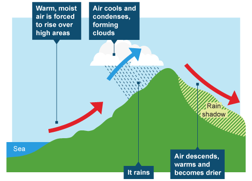
- Temperature
- Cold winters with
snow
- Cool summers with
rain
- Upper course is
affected by
relief rainfall
- In the lower
course more
frontal rain fall
- In the lower
course more
frontal rain fall
- Upper course is
affected by
relief rainfall
- Cool summers with
rain
- As you get closer to
the mouth it gets it
gets flatter, warmer
and less rain fall.
- Freeze thaw weathering
will take place in the
winter (due to
temperature)-
contributes to the
formation of a 'V' shaped
valley
- Freeze thaw weathering
will take place in the
winter (due to
temperature)-
contributes to the
formation of a 'V' shaped
valley
- Cold winters with
snow
- In the upper course
there are lots of
tributaries, a village
- A river land form that i
have learnt in the upper
course is 'V-Shaped' vallies
(made out of grit stone and
shale)
- A river land form that i
have learnt in the upper
course is 'V-Shaped' vallies
(made out of grit stone and
shale)
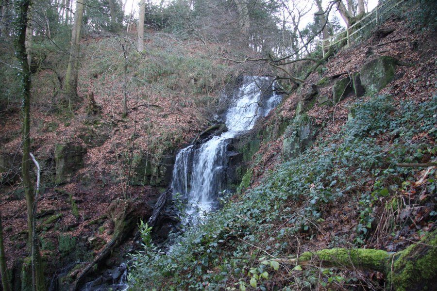
- Cleddon
Falls
- The soft rock
is shale
- The hard
rock is
gritstone
- It is 8-10 meters high
- It lies on the
tributary off
the River Wye
- It lies on the
tributary off
the River Wye
- It is 8-10 meters high
- The hard
rock is
gritstone
- The soft rock
is shale
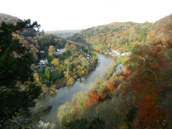
- Symonds Yat
(middle course)
- Famous tourist
spot along the
river wye.
- Massive limestone
outcrop gourge
- Famous viewing
points for
tourists
- Runs from goodrich
to chepstow
- Cannoeists use it to
test their skills
- Cannoeists use it to
test their skills
- Gourge rises
120m above the
river
- Near a huge
meander
- Near a huge
meander
- Runs from goodrich
to chepstow
- Famous viewing
points for
tourists
- Massive limestone
outcrop gourge
- Famous tourist
spot along the
river wye.
- In the middle course
there is a town
(Hereford) with
roads/ paths,
factories,meanders,
forests, leeves,
arable land for
farming
- In the lower course
there is a bridge, the
mouth, a road,flat
land,a town, an
estuary.
- It has murkey water
due to suspension
- Emptys onto the
River Severn
- Emptys onto the
River Severn
- It has murkey water
due to suspension
- How is the river wye
landscape managed
- Aforestation:It reduces the
risk of landslidesor other
mass movement by linking
the soil together (with the
roots)
- They have nice
aesthetic
- They have nice
aesthetic
- Vegetation managgement:It
decreases soil errosion because as
the vegetation decreases the rain
impact moves the soil. It also reduces
the amount of run off
- Leeves: They stop flooding,
they can be aritficual or real
- Leeves: They stop flooding,
they can be aritficual or real
- Stabalising the
channel:It can assist
with changing the
rivers response to
rainfall which
ultimately helps
settlements futher
down streem
- Letton lakes: They
gather excesse water
during flood events
and protect
Heredfordshire (in
this case)
- Floodplain
zoning: It means
making specific
zones for
farming ect.
- Floodplain
zoning: It means
making specific
zones for
farming ect.
- Letton lakes: They
gather excesse water
during flood events
and protect
Heredfordshire (in
this case)
- Aforestation:It reduces the
risk of landslidesor other
mass movement by linking
the soil together (with the
roots)
- How humans
affect the
landscape
- Wye Valley tourism: One
of tourism hotspots, with
visitors from 1700's
onwards. TinternAbbey
and viewpoins popular
- Transporty and
communications: Roads &
Railways follow the river
valley
- Forestry: trees felled for
shipbuilding and
charcoal
- Industry: limestone
quarrying increases
gradient
- Fishing, kills
animals,building roads,
Deforestation ,aforestation,
bridges have been made,
boats get petrol in the river
- Fishing, kills
animals,building roads,
Deforestation ,aforestation,
bridges have been made,
boats get petrol in the river
- Industry: limestone
quarrying increases
gradient
- Forestry: trees felled for
shipbuilding and
charcoal
- SSSI (site of special scientifc
interesy) & SAC (special area
of consevation) & AONB
(area of outstanding natural
beauty)
- Transporty and
communications: Roads &
Railways follow the river
valley
- Wye Valley tourism: One
of tourism hotspots, with
visitors from 1700's
onwards. TinternAbbey
and viewpoins popular
Media attachments
Want to create your own Mind Maps for free with GoConqr? Learn more.