Description
|
|
Created by madison1997
over 10 years ago
|
|
Page 1
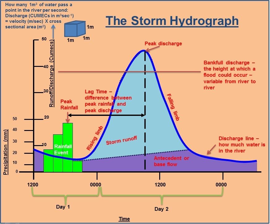
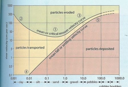
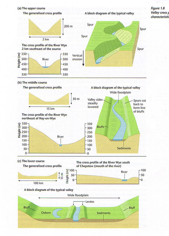
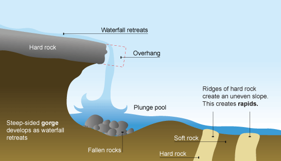
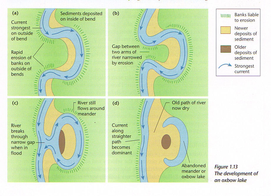
Rivers and Flood management: The Storm Hydrograph - shows variations in a rivers discharge over a short period of time, usually during a rainstorm. The starting and finishing level show the base flow of the river. As storm water enters the drainage basin the discharge rises, show by the rising limb, to reach the peak discharge, which indicates the highest flow in the channel. The receding limb show the fall in the discharge back to the base level. the time delay between maximum and minimum rainfall amount and peak discharge is the lag time. the shape of the storm hydrograph can be influenced by the intensity of the storm, the permeability if the ground, soil types, temperature, land use, urbanisation etc. Channel Processes: Erosion - rivers erode because they possess energy. their total energy depend on the weight of the water (greater the mass the more energy due to the influence of gravity on its movement) the height of the river above its base level (sea level) and the steepness of the channel. There are 4 main processes of river erosion: Abrasion is the scraping and rubbing action of materials carried along by a river (the load) Abrasion is most effective in short turbulent periods when the river levels are low. Hydraulic action is caused by the sheer power of moving water. it is the movement of loose unconsolidated material due to the frictional drag of the moving water on sediment on the channel bed. Corrosion is the most active on rocks that contain carbonates such as lime stone and chalk. the minerals dissolve and are carried away in solution. Attrition is the reduction in the size of fragments and particles in a river. There is both vertical (dominates the river attempting to cut down its base level) and lateral ( occurs more frequntly in the middle and lower streches of the river where the base level is closer to sea level) erosionTransportation: Traction is when larger stones and boulders are rolled along the river bed Saltation is when small stones bounce along the river bed suspension is when small particles are carried by the flow of the water solution is the transportation of dissolved minerals Deposition occurs when there is a decrease in energy levels therefore no longer sufficient energy to transport load. this can happen when there is a reduction in gradient, reduced discharge , increase in calibre (size of load) or reduced velocity. Valley profiles: Long profile - illustrates the changes in the altitude of the course of the river from its source along the entire length of its channel to the river mouth. in general the long profile is smoothly concave with the gradient being steeper in the upper course and becoming progressively gentler. Irregularities in the gradient frequently occur and may be represented by rapids waterfalls or lakes. There may also be marked breaks in the slope called knick points which are generally the product of rejuvenation. rejuvenation occurs when the sea level falls or when the land rises causing the river to revive its erosion activity in a vertical direction, then the river adjusts to its new base level. Cross profile - the view of the valley from one side to another. - the upper course - a narrow steep sides valley where the river occupies all of the valley floor due to dominating vertical erosion - the middle course - a wider valley with distinct valley bluffs and a flat flood plain. this is the result of lateral erosion which widens the valley floor. - the lower course - a very wide flat flood plain in which the valley sides are difficult to locate. here there is a lack of erosion and reduced competence of the river, which results in large scale deposition. Graded profile - over a long period of time a river may display an even and progressive decrease in gradient down a valley creating a typical smooth concave shape which has adjusted to the discharge and the load of the river. Profile of dynamic equilibrium is where a balance has been achieved between the processes of erosion and deposition. Potential and Kinetic energyin relation to rivers, potential or stored energy is fixed by the altitude of the source of the stream in relation to base level. kinetic energy or energy due to movement is generated by the flow of the river which converts potential energy into moving energy. an increase in velocity and or discharge results in an increase in kinetic energy, The shape of the channel influences the velocity of the river. in the upper course, where the channel is narrow and uneven due to the presence of large boulders, there is a large wetted perimeter . the wetted perimeter is the total length of the river bed and banks in cross section that are in contact with the water in the channel. Channel shape is described by the hydraulic radius (hydraulic radius = cross sectional area of the channel / wetted perimeter) a high hydraulic radius means that the river is efficient.Landforms of fluvial erosion and deposition: - waterfalls and rapids - occur when there is a sudden change in gradient as the rive flows down stream. they may be the result of a resistant band of rock occurring across the course of the river, the edge of a plateau or the rejuvenation of the area. - potholes- are cylindrical holes drilled into the rocky bed of a river by turbulent high velocity water loaded with pebbles, pebbles become trapped in slight hollows and vertical edges and grinds holes in the rock ( Abrasion) . Attrition rounds of the pebble reducing the bed load. -Braided channels - occurs when the river is forced to split into several channels separated by islands.- Meanders and and oxbow lakes-
Want to create your own Notes for free with GoConqr? Learn more.