Page 1
Unit 3
Geologic History: Divergent plates create ridges and convergent(subduction zones) create trenches.Tsunamis are created by an underwater earthquake created at a subduction zone, that causes a large wave.Wegener developed the theory of continental drift; 300 million years ago there was constant motion of Earth's land masses and formed one supercontinent called Pangea.Plate tectonics is the theory that the Earth's outer shell is made up of 20 slow-moving plates, floating on a layer of hot rock because of convection currents.Evidence for Wegener's theory includes the jigsaw fit, same fossils, similar mountains, and ice sheets.Plate tectonics have shaped Canada in many ways such as development of mountains, formation of fossil fuels, etc.Geologic time consists of 4 eras: cenozoic, mesozoic, paleozoic, and precambrian.Understanding of Canada's landforms is shown by: TECSMERG ( Tectonic forces, erosion, conflict, sedimentary rock, metamorphic rock, economic activity, recent events, and glaciers). *See notebook for details*The Canadian Shield, Appalacians, and Western Cordillera are mountains affected by erosion, two of which formed by collision of tectonic plates.Canada's LandformsThe Canadian shield:-oldest and most eroded igneous and metamorphic rock-rich diamond and metallic mineral deposits-thin soil-recreation and tourism-disorganized drainage pattern-hydro powerInterior Plains:-covered by shallow inland seas, sediments were deposited and compressed-oil and gas -mineral deposits under newer rocks and glacial deposits-rolling hills, deep wide river valleys-three different levels of elevation-deep and fertile soil-agriculture and beef productsGreat Lakes-St.Lawrence Lowlands:-bedrock formed in Paleozoic era-rolling landscape-flat plains with glacial hills and deep river valleys-agriculture-transportation routes and development of cities-most densely populatedHudson Bay-Arctic Lowlands:-flat, low area covered with swampy forest-layers of sedimentary rock rest on top of shield rock and waters had covered the lowland-arctic lowlands have gently rolling landscape-harsh climateAppalachian Mountains:-all types of rock-sedimentary rock were uplifted and folded at end of Paleozic during formation of Pangea-non metallic minerals-plateaus of igneous and metamorphic contain metallic minerals-rolling mountains and hills-fertile river valleys and drowned coastlineInnuitian Mountains:-Mesozoic era, North american plate moved northward-mostly sedimentary-cold temperatures and permafrost-too remote for mineral exploitationWestern Cordillera-collision of North American and Pacific plates-all types of rock in three major divisions-plateaus and valleys-limits growth of cities-difficult to have transportation routes because of the direction of mountains & valleys-lightly populated-farming and mining-tourismCanada's Climate1. Canada is large;extends a vast distance from north to south and east to west.2.Different elevations produce different climate conditions.3.Coastal regions have different climates than inland regions.4.Wind and pressure systems move weather conditions to one part of the country to other parts.Latitude:Places closer to the poles have colder climates than places near the equator because the same amount of energy from the Sun must be spread over a larger area.Ocean currents:An ocean's temperature affects the temperature of air that passes over it. An ocean current's temperature in comparison to water around it determines its temperature. Winds and air masses: Air masses take on the climatic conditions of the area where they are formed and carries those characteristics as they are moved, by prevailing winds.Elevation: Temperature decreases as elevation increases because air masses expand and cool as they rise, turn into water vapour, condense into clouds and may form precipitation. Heat is released through the process of condensation and the air mass slows its cooling process as it rises.Relief: When air moves up the windward slope of a mountain, the rates of condensation and precipitation increase but when air moves down the leeward slope the evaporation rate increases and creates a drier climate.+Near water: Large bodies of water moderates temperatures of the land near them which have a maritime climate. Continental climates take place in areas far from bodies of water and have great temperature ranges.Great Lakes are far from oceans but they influence climate of land by reducing temperature and being a source of moisture, called modified continental.Maritime:- - >1000mm-max. precipitation in winter (large difference=west, small=east)Continental:- >25C- -max. rain in summer
Studying PopulationImportant rates are birth rate, death rate, natural increase rate, immigration rate, emigration rate, net migration rate and population growth rate. Population growth can be examined with doubling time and the rule of 70.A population pyramid can show many things such as dependency load.The demographic transition model can show the stages of a country.ImmigrationIn the past, most immigrants have come from Europe but now most come from Asia. People leave their countries due to either pull or push factors, however intervening obstacles can interfere with their decision. There are three types of immigrants: economic, family and refugee. Interprovincial immigration is immigrating into another province in the same country. Canada has a low birthrate and needs immigration to help an aging population that cannot grow on natural increase alone and to replace baby boomers in the work force. Urban Settlement Patterns Urbanization: -identified by an increase in population density -highly concentrated distribution pattern -grew when immigrants who had settled in farms, moved to urban areas for jobs There are usually 3 non-basic industries for every basic industry; this is called the multiplier effect. High order: Products that require a large threshold population and are expensive/purchased infrequently. Middle order: Goods needed from time to time and require large threshold population. Low order: Require small threshold population and needed frequently. Diversified urban centres are urban cities with multiple urban functions. -manufacturing cities -transportation hubs -tourist cities -government centres -resource based communities urban growth: the number of people by which a city's population growsurbanization:process of change from rural to urban Urban Land UseThe two factors that influence residential density are the cost of land and the age of the neighborhood.Types of commercial land use:1. Local service centres2. Neighbourhood plazas and ribbons3. Community Shopping Centres4.Power centres5.Regional shopping centres6.Central Business DistrictLand Use Fatcors:-land value-zoning-climate-technologyImportant terms to know are rural-urban fringe, urban sprawl, and new urbanism. Four types of areas in the Oak Ridges Moraine:1.Natural Core: Greatest concentration of natural features2.Natural Linkage: Natural and open space linkages between natural core areas and rivers and streams.3.Countryside Areas:Agricultural and rural transition between natural core, linkage and settlement.4.Settlement: Range of urban uses set out in municipal plans of existing moraine communities.
Unit 4
Unit 5
Sectors of the Economy:The types of jobs are primary, secondary, tertiary and quaternary.Jobs in the quaternary industry are growing while those in primary and secondary are decreasing.Primary industries:extraction of raw materialsSecondary industries:processing into finished goods (value added)tertiary industries:range of servicesquaternary: processing of ideasFishing:An Industry in CrisisDifferent kinds of fish are ground fish, pelagic fish, and shellfish.Exporting fish helps Canada with its balance of trade.Most important markets for fish are the US, Western Europe, and Japan.Pros of Great Banks:-shallow waters and continental shelf allows sunlight to penetrate to the bottom and grow plankton which attracts fish-cold and warm currents meet, churning nutrients from the bottom5 reasons for collapse of east Coast fishery:-Overfishing-improved fishing technology-uncontrolled foreign fishing-destructive fishing practices-changes in natural conditions3 reasons for partial collapse of west coast fishery:-overfishing-changes in environment-lack of a salmon fishing treatyChallenges to west coast fishery:1.First nations2.Sport fishing3.Commercial fishing
Unit 6
Canada and the World:Reasons for increase in International connections:-travel-communication and technology-trade and linked economies-common culture-natural hazards,war, and terrorismDeveloped:Developing:Newly Industrializing:Determined by:-life expectancy-GDP-natural increase rate-food supply-education level-health careLimitations to grouping countries:1. defintions of "progress" and "development"2.what is not revealed by GDP3.groups contain a wide range of countriesInternational relationshipsOther countries have a competitive advantage over Canda because their labour costs are lower.Gloablization can also be seen as Americanization.Walt disney-US-entertainmentShell Oil-Netherlands-oilbata-Canada-shoestoyota-japan-automobilesmicrosoft-US-computerbombardier-canada-aircraft and trainspanasonic-japan-electronicsadidas-germany-atheltic
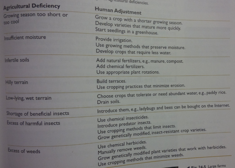
Farming:Agriculture depends on the interaction of climate, soil, biology, and topography.The two variables in climate that contribute to the success of farming are solar energy/heat and moisture.Growing degree-days are calculated by adding together the daily GDDs( the number of degrees the temperature exceeds 6)Farmers use other heat measures such as growing season and frost-free period.Farmers need to know how much precipitation and how much evapotranspiration takes place.The most important factor in a soil's fertility is the amount of humus.Some organisms can be beneficial or destructive to farming.Level, well drained land is best for farming while mountains, hilly areas, and sandy areas are less productive.
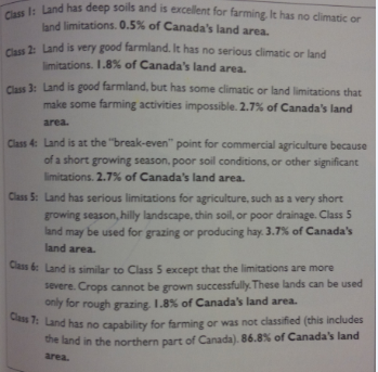
Crop and animal production contribute about 1.4% to Canada's GDP.When all jobs are counted, 20% is related to agricultural sector. Land can be classified as a renewable and non renewable resource.Seven classes that describe land capabilityIncreased mechanization has brought an increase in the size of farms and decline in numbers.Types of farming are dertermined by economic factors as well:-Cost or value of land-Proximity to market-CompetitionIntensive farming is small but produce large profits per hectare.Extensive farming is large but produces low yields per hectare.Issues facing farmers include: loss of farmland, decline of the family farm, sustainable agriculture, organic farming, BSE, GMOsLand can be renewable or nonrenewable because it can support new crops yearly. However, it is nonrenewable because there is a limited amount and once it is used up we cant create more.Today, less people can operate larger farms due to mechanization.
Key Terms:conventional energy source: a well-established source of energyWe rely mostly on these sources, mostly oil and natural gas.alternative energy source: a non conventional energy source, used as a greener version/alternative for conventional sourcesConventional sources release large amounts of fixed carbon and it is significant that we must use more alternative sources to reduce greenhouse gases and climate change.biomass energy:energy produced by the combustion of biomass materialsIt is an alternative energy source, which we should start using more often if we want to decrease the amounts of greenhouse gases released into the atmosphere.thermal-electric generating station: a facility generating electricity by burning fuel to create heat, and then steam.It is the least expensive type of plant to build. However, it uses a non-renewable resource, contributing to climate change and acid rain.nuclear-electric generating station:a plant that splits atoms of radioactive materials to create heat, and in turn is used to create electricityIt does not contribute to climate change but can be very hazardous and dangerous (e.g. Fukishima and Chernobyl)greenhouse gases: gases that contribute to global warmingThey prevent the world from being cold and lifeless like other planets in our solar system, but if there is too much in our atmosphere it adds to climate change.oil sand:mixture of heavy crude oil, sand and waterOil sands contain bitumen which can be made into synthetic crude oil. Oil sands supplying oil will go up as other reserves are depleted and prices increase.carbon sink:a reservoir that stores carbon and moderates it in the atmosphereCarbon sinks moderate carbon dioxide building up in the atmosphere by removing it and storing it for periods of time, helping reduce global warming. If the world continues to warm though, it may reduce the efficiency of carbon sinks to reduce climate change (e.g. warming oceans).
.Many people feel that nuclear generating plants are a major problem because the fuel and waste products are radioactive and dangerous. The wastes do not have a safe disposal solution, so they must remain dangerous for long periods of time. The fuel must also be handled carefully otherwise there may be dire consequences. Due to explosions of nuclear reactors such as Chernobyl in Ukraine and Fukishima in Japan, people are aware of the possible consequences that come with nuclear reactors. Simple mistakes can cost thousands of lives and dollars.Average Canadian families can change their behavior to significantly reduce the amount of energy used by participating in activities that have a smaller ecological footprint. For example, riding you bicycle to school or walking instead of getting a ride can reduce global warming and the amount of energy you use. When you are riding your bike or walking you do not release any emissions or use any fuel (except to fuel your body). This s a simple way to limit global warming and limit the energy you use. Even simpler ways are managing temperature in your home(wearing a sweater when its cold inside), reading energuide labels, and turning off appliances when not in use.Also, canadian famillies can try the One-Tonne challenge to limit greenhouse gases released as well as the energy consumed by appliances they use. Ice Sheets: Polar ice sheets would melt and increase sea levels. This could affect low-lying coastal areas around the world. Precipitation: High temperatures would cause more evaporation from the oceans and in turn more precipitation. Since it would not be evenly spread, drought and flooding could increase. Forests: dry temperatures would cause forests to die and make global warming worse. Forest distribution would also change, affecting economies of some places. Glaciers: Glaciers are shrinking, many wildlife rely on these glaciers. Agriculture: Productiveness would vary due to precipitation. Refugees: Canada would have to accept many refugees from places affected by the weather conditions and sea levels.Decline in Food Supply, Loss of Hunting, fishing, and Gathering Culture: Many Arctic species are being affected by rising temperatures and are declining. This means that the food supply of the Arctic people is decreasing and makes it difficult for them to hunt, fish and gather. Their lifestyle and culture therefore declines. Thawing Permafrost: Permafrost temperatures increase by 2C and the layer that thaws in spring becomes deeper annually. The melted water changes freshwater lake patterns, wetlands, wildlife, and drainage. Reduced Sea Ice: As ice decreases, marine transport increases as new waterways, access to shipping channels, and opportunities to mine open. Enhanced Marine fisheries: Freshwater fishing may decline while marine fisheries will increase due to the warmer temperature. Enhanced Agriculture and Forestry: Longer and warmer growing seasons and increased precipitation will increase agriculture and forestry.-Average global temperature dropped by as little as 4 degrees.-The earliest European settlement was by the Vikings.-Without greenhouse gases, the world's average temperature would drop by 33 degrees-The wavelength of sunlight is short-Forests are a example of a carbon sink-Average global temperature in the next 100 years could increase by 1 to 5.8 degrees-Global warming increases precipitation-World's most important carbon sinks are oceans-Global warming makes oceans less efficient energy sinks.-the average canadian releases 5 tonnes of greenhouse gases into the air each year.-Polar regions are affected the most by global warming.Canadians are the largest or second largest users of energy in the world because we live in a colder climate which requires more heating and food supply, we have a small population spread over a large land mass which requires transportation,and we have an advanced industrial economy that uses a lot of energy.Oil companies use secondary recovery because when oil is removed from a deposit, there is still some remaining. Although only about 60% can actually be recovered, companies try so they can remove more oil and gain more profit.The operation of thermal electric plants contributes to global warming and acid rain.Forests can act as both carbon sinks and sources because when they are burned, they release carbon. However, when they use the process of photosynthesis, they take carbon dioxide from the atmosphere. The melting permafrost causes:changes in animals' access to breeding grounds and migration routes, disappearance of freshwater lakes, less stability in soil for forests, transportation routes, disruption in local communities.*****Global warming will affect:a) permafrost areas in Canada, because it will decrease the temperature of permafrost by 2 degrees. This will affect "b) shipping through the St. Lawrence Seaway and Great Lakes, because water levels will rise due to precipitation or lower due to evaporation. This could cause lower loads on ships. This could decrease the economical efficiency of shipping through these areas.c)recreational activities, because it may make more opportunities to participate in recreational activities in the oceans and can expand to the north (on land). Some activities such as skiing or snowboarding will be affected due to less snow. also, it could affect sportfishing and boating as well as beaches due to higher water levels. As well as forests and parks because many trees may die due to increased dryness/evaporation.
Unit 3
Unit 4
Unit 5
Unit 6
Chapter 27,37
Want to create your own Notes for free with GoConqr? Learn more.