
Flashcards
rivers
Flashcards do conjunto (55)
- 1What are the stages of a riverUpper/Youthful
Middle/Mature
Lower /Old - 2Name the main features of the Upper/ Youthful stageV-shaped valleys
Interlocking spurs
Waterfalls - 3Name the main features of the Middle/ Mature stageMeanders
Oxbow lakes - 4Name the main features of the Lower/ Old stageLevees
Flood plains
Deltas - 5Define ErosionThe water WEARS the landscape away
- 6The river erodes the bed and bank through a number of processes. what are they?Hydraulic action
Abrasion
Attrition
Solution
(HAAS) - 7Define Hydraulic actionThe FORCE of the moving water wears away the bank of the river
- 8Define AbrasionSmall stones carried by the river WEAR away the banks and bed of the river
- 9Define AttritionSmall stones are worn down and broken up as the HIT off each other
- 10Define SolutionRocks such as limestone and soil are DISSOLVED by acids in the water
- 11Define transportationThe river CARRIES the material it has eroded
- 12What are the methods of river transportationRolling/Traction
Bouncing/Saltation
Suspension
Solution - 13Define Rolling/TractionWhen the larger stones are ROLLED along the bed of the river
- 14Define Bouncing/SaltationWhen the smaller pebbles are BOUNCED along the bed of the river
- 15Define SuspensionWhen light materials such as sand and silt FLOAT along in the water
- 16Define SolutionWhen materials DISSOLVE in the water and are carried along by the river
- 17What is the material transported by the river calledLoad
- 18Define DepositionIt can shape the land by leaving SEDIMENT in new places, making new land or adding to existing land
- 19What are the causes of deposition?1) Reduction in the river's speed (e.g. when entering lake/during dry weather)
2) Increase in load size (e.g. When the tributary joins the river/heavy rainfall)
3) Reduction in river's volume (e.g. During period of dry weather)
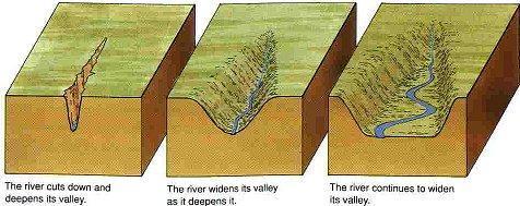
4) When the gradient levels off (When the river reaches flatter land) - 20Name the 3 stage in the youthful / upper stageV shaped Valleys
Interlocking Spurs
Waterfalls - 21What is a V shaped Valley?- A STEEP SIDED VALLEY in the shape of a V
- It is shaped by vertical erosion
-Hydraulic action creates a steep, deep and narrow valley - 22How is a V Shaped Valley formed?Is formed when hydraulic action occurs and creates a deep, narrow valley. Then mechanical weathering like 'freeze thaw action' and mass movement weather the sides of the valley
- 23What is an interlocking spur?Interlocking spurs are areas of high ground that jut out of both sides of a v shaped valley
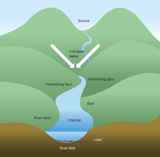
- 24How is an interlocking spur formed?As the river erodes the landscape in the upper course, it winds around areas of hard rock that it cannot wear down. It still erodes vertically, however.
- 25Give a example of a v shaped valley?The River MOY
The River LIFFEY - 26Give an example of an interlocking SpurRiver BARROW
River SLANEY - 27Define WaterfallA feature of river erosion. It occurs when a river flows over a vertical drop. E.g. Powerscourt waterfall, Co.Wicklow
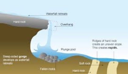
- 28How is a waterfall formedProcess:
When a river flows over an area comprising a layer of hard rock above a layer of soft rock, the soft rock gets eroded quicker by the processes of Hydraulic action, abrasion and solution.
Explanation:
This creates a fall in the river. A plunge pool form at the base of the waterfall due to the force of the falling water. Undercutting then takes place and creates an overhang. This overhang eventually collapses and the waterfall retreats - 29DEPED Do Eat Porridge Each DayDescription
Example
Processes
Explanation
Diagram - 30Define MeanderDescription
Meanders are curves or bends in the river as it flows along the course in its mature stage.
Process
As the rivers erodes laterally, to the right and to the left it forms large bends called meanders.
Explanation
The rivers hydraulic action erodes and undercuts the riverbank on the outside of the bend, where water flow has most energy due to decreased friction. Meanwhile, material is deposited on the inside of the bend, where the river flow is slower and there is greater friction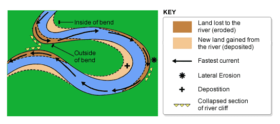
- 31Give an example of meandersRiver Shannon
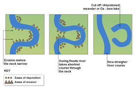
River Moy - 32What is an oxbow lakeA horseshoe shaped lake that is formed when a meander is cut off from a river
- 33How is an oxbow lake formed?Explanation:
When the neck of a meander becomes very tight, the river can break through. For example, during a flood the river has a higher flow of water and more energy.
Processes:
The neck of the meander becomes tight and the river can break through. Then waste is deposited leaving the oxbow cut off from the river - 34Give an example of an oxbow lakeRiver Liffey
River Moy - 35Name the 3 parts of the old stage/lower course of the riverFlood plains
Levees
Deltas - 36What is a flood plain?A floodplain is a wide, flat area of land on either side of the river in its old stage
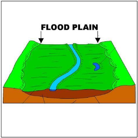
- 37How is a flood plain formed?The river is now nearing the sea, and deposition has become a main process. The river carries a large load of sediment known as alluvium. During a flood, the river spreads out over the flood plain, and drops the load its carrying. The flood plain is made up of a thick layer of alluvium, which makes it very fertile and good for farming. The highest point reached by the river when in flood is called the bluff line
- 38Give an example of a flood plainRiver Boyne
River Moy - 39What is a levee?A levee is a build up of alluvium on the banks of a river. Levees are caused by floods.
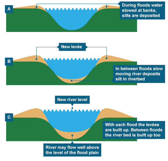
- 40How is a levee formedIn times of low flow, material is deposited on the river bed, raising the height of the riverbed. In times of flood, the water leaves the channel. As it does so, it looses energy and deposits its load. After many floods the river builds a bank on either side. Artificial levees can be made.
- 41Give an example of a leveeRiver Liffey
River Moy - 42What is a Delta?A triangular / fan shaped area of land at the mouth of the river where is enters the sea. Deltas are features of deposition found in the old stage of the river
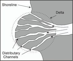
- 43How is a Delta formed?They form where the river mouths become choked with sediment, causing the main river channel to split into many smaller channels or distributaries.
Deltas form only under certain conditions: - The river must be transporting a large amount of sediment
- The sea must have a small tidal range and weak currents
- The sea must be shallow at the river mouth - 44Give an example of a DeltaThe Mississippi Delta
The Nile Delta - 45Provide examples of human interactions with riversTransport
Tourism
Fishing
Settlement
Pollution
Flooding
Hydroelectric Power (HEP) - 46How do we use rivers for transport?To transport People & Goods
- 47How do we use rivers for tourism?Tourists use rivers for cruising & fishing
- 48How do we use rivers for fishing?We use rivers to catch fish for human consumption
- 49Rivers are also used for settlementExample: Drogheda-built around a river
- 50How do we pollute rivers?Farming; When farmers spread slurry on their land it can seep into rivers causing pollution and death of fish stocks
Domestic; Waste material from septic tanks can seep into rivers (see above)
Industrial Waste: If factories dump waste into rivers it can also cause pollution - 51Flooding-Human interactionHuman interaction can be responsible for flooding. Cutting down trees can lead to more surface run off as well as soil erosion and this can lead to deposition on riverbeds causing the river to rise and burst its banks
- 52HEP (Hydro electric Power)Hep stations are often built using dams. The building of dams can have a positive and negative impact on a river.
- 53What is a Dam?A dam is a large concrete wall built across a river to try to control the flow of water
- 54What are the positive aspects of HEP?1) HEP stations and turbines can be placed in a dam to harness the power of the water and generate cheap, clean, renewable electricity.
2) The water that builds up behind a dam is known as a reservoir. This can provide a water supply to urban areas
3) The reservoir can also be used for leisure activities such as boating, fishing and water sports - 55What are the negative aspects of HEP?1) The creation of a reservoir behind the dam may mean losing good agricultural land
2) Families that live in the dam and reservoir area have to be relocated from their homes
3) New roads and bridges have to be built to facilitate the reservoir
4) Fish stocks can be affected by the dam and the restriction on fish swimming upstream
Informações
- Descrição
- Second year Geography FlashCards sobre rivers, criado por Danny Little em 15-01-2018.
- Criado por
- Danny Little
- Visualizações
- 0
- Avaliação