
Flashcards
Rivers
Flashcards do conjunto (37)
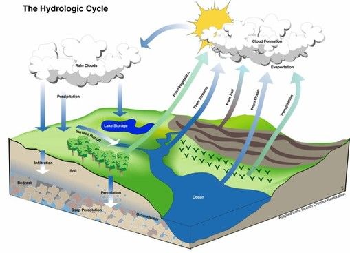
- 1The drainage basin hydrological cycleThe drainage basin hydrologicals system is an open system with inputs and outputs.
- 2Drainage basinThe drainage basin is the catchment area fom which a river system obtains its water.
- 3WatershedAn imaginary line called the watershed delimits one drainage basin from another. The watershed generally follows a ridge of high land; any rain falling on the other side of the ridge will eventually flow into another river in the adjacent drainage basin.
- 4What inputs are there into the drainage basin?Inputs into the drainage basin include:
· Energy from the sun for evaporation
· Precipitation - rain & snow - 5What outputs are there moving out the drainage basin?Outputs move moisture out of the drainage basin and include:
· Evaporation and transpiration from plants (collectively called evapo-transpiration)
· Runoff into the sea
· Water percolating deep into underground stores where it can be effectvely lost from the system - 6Stores of water· On the surface - glaciers, lakes, rivers, puddles
· Vegetation stores water by interception and plants
· The soil can hold water
· Groundwater is stored in permeable rocks - 7Transfers and flowsmoves water through the system and enable inputs of water to be processed from one store to another.
· Transfers include throughfall, stemflow, infiltration, throughflow and groundwater flow. - 8Channel processesThe work of a river involves three main processes: erosion, transportation and deposition. At any one time the dominant process operating within the river depends on the amount fo energy avaliable. This is governed by the velocity of the flow and the amount of water flowing within the channel (discharge).
- 9AbrasionThe scraping, scouring and rubbing action of materials carried along by a river (load). Rivers carry rock fragments in the flow of the water or drag them along the bed, and in doing so wear away the banks and bed of the river channel.
- 10Hydraulic actionThis is caused by the sheer power of moving water. It is the movement of loose unconsolidated material due to the frictional drag of the moving water on sediment lying on the channel bed.
- 11CorrosionThis is most active on rocks that contain carbonates, such as limestone and chalk. The minerals in the rock are dissolved by weak acids in the river water and carried away in solution.
- 12AttritionThis is the reduction in the size of fragments and particles within a river due to the processes describe above. The fragements strike one another as well as the river bed. They therefore become smoother, smaller and more rounded as they move along the river channel.
- 13TransportRiver energy not used for erosion is not lost through friction can be used to transport a river's load. A river obtains its load from two main source:
· Material that has been washed, or has fallen, into the river from the valley sides
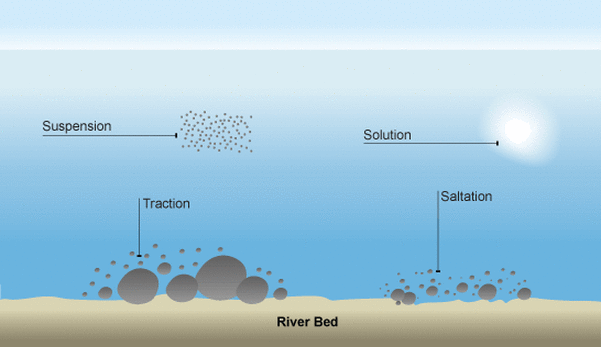
· Material that has been eroded by the river itself from the bed or banks - 14Tractionlarge stones and boulders are rolled along the river bed by water moving downstream. This mainly happens during periods of high discharge and consequently high energy levels
- 15Saltationsmall stones bounce or leap-frog along the channel bed. This process is associated with relatively high energy conditions. Small particles may be thrust up from
the bed of the river only to fall back to the bottom again further downstream. As these particles land they in turn dislodge other particles upwards, causing more such bouncing movement to take place - 16Suspension– very small particles of sand and silt are carried along by the flow of the river. Such material is not only carried but it is also picked up, mainly through the
turbulence that exists within the river. Suspension normally contributes the largest proportion of sediment to the load of the rover. The suspended load is the main cause of the brown appearance of many rivers and streams - 17Solution– dissolved minerals are transported with the mass of moving water
- 18Transportation image
- 19DepositionA river deposits when there is a decrease in its level of energy, it is no longer competent to transprt its load, Deposition usually occurs when:
· There is a reduction in the gradient of the river, for example when it enters a lake
· The discharge is reduced, such as during and after a dry spell of weather
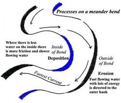
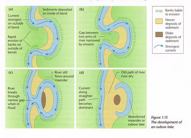
· There is shallow water, for example on the inside of a meander
· There is an increase in the calibre (size) of the load. This may be due to a tributary bringing in larger particles, increased erosion along the river’s course, or a landslide
into the river
· The river floods and overtops its banks, resulting in a reduced velocity on the floodplain outside the main channel - 20River dischargeRiver discharge is defined as the volume of water passing a measuring point or gauging station in a river in a given time. It is measured in cubic metres per second (cumecs).
- 21The storm hydrographThe storm hydrograph shows variations in a river's discharge over a short period of time, usually during a rainstorm
- 22The storm hydrographThe starting and finishing level show the base flow of the river. As storm water enters the drainage basin the discharge rises, shown by the rising limb, to reach the peak discharge, which indicates the highest flow in the channel. The receding limb shows the fall in the discharge back to the base level. The time delay between maximum rainfall amount and peak discharge is the lag time
- 23How does Rock and soil type affect the river's discharge· Permeable rocks ad soils (such as sandy soils) absorb water easily, so surface run-off is rare
· Impermeable rock and soils (such as clay soils) are more closely packed. Rainwater can’t infiltrate, so water reaches the river more quickly
· Pervious rocks (like limestone) allow water to pass through joints, and porous rocks (like chalk) have spaces between the rock particles - 24How does land use affect the river's discharge· In urban areas, surfaces like roads are impermeable – water can’t soak into the ground. Instead, it runs into drains, gathers speed and joins rainwater from
other drains – eventually spilling into the river
· In rural areas, ploughing up and down (instead of across) hillsides creates channels which allow rainwater to reach rivers faster increasing discharge
· Deforestation means less interception, so rain reaches the ground faster. The ground is likely to become saturated and surface run-off will increase - 25How does rainfall affect the river's discharge· The amount and type of rainfall will affect a river’s discharge
· Antecedent rainfall is rain that has already happened. It can mean that the ground has become saturated. Further rain will then flow as surface run-off towards the river
· Heavy continual rain, or melting snow, means more water flowing into the river - 26How does Relief affect the river discharge?· Steep slopes mean that rainwater is likely to run straight over the surface before it can infiltrate. On more gentle slopes infiltration is more likely.
- 27How do weather conditions affect river discharge?· Hot dry weather can bake the soil, so that when it rains the water can’t soak in. Instead, it will run off the surface, straight into the river.
· High temperatures increase evaporation rates from water surfaces, and transpiration from plants – reducing discharge
· Long periods of extreme cold weather can lead to frozen ground, so that water can’t soak in - 28Waterfalls
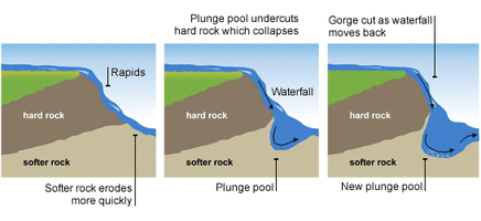
- 29WatterfallsFormation of a waterfall:
1.Waterfalls are found in the upper course of a river. They usually occur where
a band of hard rock lies next to soft rock. They may often start as
rapids.
2. As the river passes over the hard rock, the soft rock below is
eroded (worn away) more quickly than the hard rock leaving the hard rock
elevated above the stream bed below.
3. The 'step' in the river bed continues
to develop as the river flows over the hard rock step (Cap Rock) as a vertical
drop.
4. The drop gets steeper as the river erodes the soft rock beneath by
processes such as abrasion and hydraulic action. A plunge pool forms at the base
of the waterfall.
5. This erosion gradually undercuts the hard rock and the
plunge pool gets bigger due to further hydraulic action and abrasion. Eventually
the hard cap rock is unsupported and collapses. The rocks that fall into the
plunge pool will continue to enlarge it by abrasion as they are swirled around.
A steep sided valley known as a gorge is left behind and as the process
continues the waterfall gradually retreats upstream. - 30Meanders
- 31Oxbow lakes
- 32FloodplainsFloodplains are created as a result of both erosion and deposition, although the accumulation of river deposits suggests that they are predominately depositional features. They are relatively flat areas of land either side of the river, which form the valley floor in the middle and lower courses of the river
- 33Delta
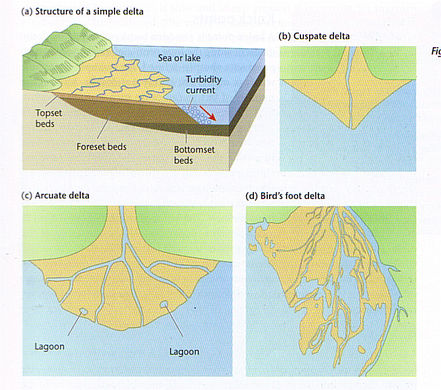
- 34DeltaA delta is a feature of deposition, located at the mouth of a river as it enters a sea or lake. Deposition occurs as the velocity and sediment-carrying capacity of the river decrease on entering the lake or sea, and bedload and suspended material are dumped
- 35Hazarda ntural event that threatens life and property. A disaster is the realisation of the hazard. Flooding is an exmaple of a natural hazard
- 36River managementRiver basins are subject to strategies desigined to prevent flooding and to ensure that there is an adequate supply of water
- 37The impact of human activities on flooding- Urbanisation
- Deforestation
- River Management
Informações
- Descrição
- GCSE Geography (Theme 2) FlashCards sobre Rivers, criado por Samah Salih em 06-05-2017.
- Criado por
- Samah Salih
- Visualizações
- 11
- Avaliação