
Mapa mental
LEDC Earthquake Case Study: Port-au-Prince, Haiti
Conteúdo do mapa
LEDC Earthquake Case Study: Port-au-Prince, Haiti
Causes
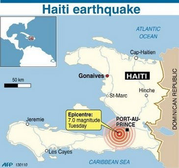
- 12th January 2010
- 16:53 local time
- Conservative Plate Margin
- North American and Caribbean plate slid past each other
- Magnitude: 7
- Epicentre was 15 miles away from
- Shallow focus earthquake
- 13km deep
- 12th January 2010
Effects
- Social
- 200,000 deaths
- Pancaking of buildings
- Buildings weren't designed well-no cross bracing or steel struts installed into concrete walls
- Responsible for deaths and people becoming trapped
- Pancaking of buildings
- 1.5 million left homeless
- 300,000 injured
- Outbreak of cholera claimed hundreds of lives
- Prison destroyed releasing over 4,000 inmates
- 200,000 deaths
- Environmental
- Ground type was not suitable to build on
- Loose sediments such as soil and sand-amplification occured
- Took only 60 seconds to level city
- Buildings built on land susceptible to earthquakes
- Land movement generated localised tsunamis-killed a total of 7 people
- Ground type was not suitable to build on
- Social
Responses
- Short Term
- 800,000 moved to aid camps
- 120,000 tens and over a million tarpaulin shelters provided
- Lack of immediate aid, people relied on themselves
- Long Term
- Support for 70% Haitians through cash/food-for-work projects
- Temporary schools created
- Water and sanitation eventually supplied
- Short Term
Imagens e arquivos do mapa
Informações
- Descrição
- A Levels Geography (Physical Geography-A2 Case Studies) Mapa Mental sobre LEDC Earthquake Case Study: Port-au-Prince, Haiti, criado por Andrew_Ellinas em 26-02-2015.
- Criado por
- Andrew_Ellinas
- Visualizações
- 61
- Avaliação