
Mapa mental
Water on Land
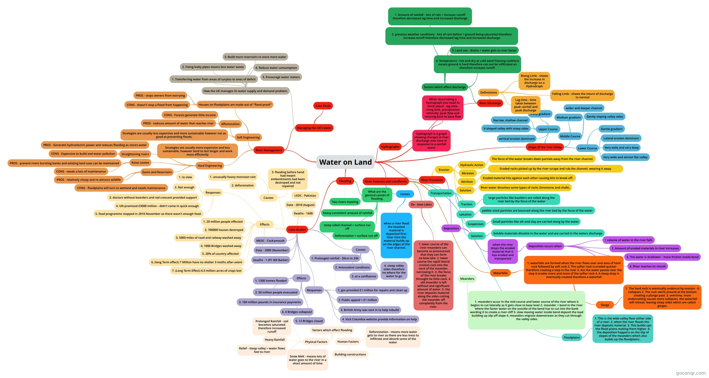
Mind map: Water on Land
Conteúdo do mapa
Water on Land
shape of the river Valley
- Upper Course
- steep gradient
- V-shaped valley with steep sides
- Narrow, shallow channel
- vertical erosion dominant
- Middle Course
- Medium gradient
- Gently sloping valley sides
- wider and deeper channel
- Lower Course
- Gentle gradient
- Very wide and almost flat valley
- Very wide and very deep
- Lateral erosion dominant
- Upper Course
River Processes
- Erosion
- Hydraulic Action
- The force of the water breaks down partials away from the river channel.
- Abrasion
- Eroded rocks picked up by the river scrape and rub the channel, wearing it away.
- Attrition
- Eroded material hits against each other causing bits to break off.
- Solution
- River water dissolves some types of rocks (limestone and chalk).
- Hydraulic Action
- Transportation
- Traction
- large particles like boulders are rolled along the river bed by the force of the water
- saltation
- pebble sized particles are bounced along the river bed by the force of the water
- Suspension
- Small particles like silt and clay are carried along by the water
- Solution
- Soluble materials dissolve in the water and are carried in the waters discharge
- Traction
- Deposition
- when the river drops the eroded material that it has eroded and transported
- Deposition occurs when
- !. volume of water in the river falls
- 2. Amount of eroded materials in river increases
- 3. The water is shallower - more friction inside bend
- 4. River reaches its mouth
- Deposition occurs when
- when the river drops the eroded material that it has eroded and transported
- Erosion
River Features and Landforms
- Waterfalls
- 1. waterfalls are formed when the river flows over and area of hard rock followed by soft rock 2. The softer rock is eroded quicker therefore creating a step in the river 3. Ass the water passes over the step it erodes more and more of the softer rock 4. A steep drop is eventually created therefore a waterfall
- Gorge
- 1. The hard rock is eventually undercut by erosion - it collapses 2. The rock swirls around at the bottom creating a plunge pool. 3. overtime, more undercutting causes more collapses. the waterfall will retreat, leaving steep sides which are called gorges.
- Gorge
- 1. waterfalls are formed when the river flows over and area of hard rock followed by soft rock 2. The softer rock is eroded quicker therefore creating a step in the river 3. Ass the water passes over the step it erodes more and more of the softer rock 4. A steep drop is eventually created therefore a waterfall
- Meanders
- 1. meanders occur in the mid course and lower course of the river where it begins to cut laterally as it gets close to base level 2. meander = bend in the river where the faster water on the outside of the bend has to cut into the bank wording it to create a river cliff 3. slow moving water inside bend deposit the load building up slip off slope 4. meanders migrate downstream as they cut through the valley sides
- Ox - bow Lakes
- 1. lower course of the river meanders can become so pronounced that they can form ox-bow lake. 2. lower course the rapid lateral erosion cuts into the neck of the meander, narrowing it. 3. the force of the river breaks throught he little neck. 4. old meander is left without and significant amount of water. 5. the river deposits material along the sides cutting the meander off completely from the river.
- Levees
- when a river flood the heaviest material is deposited first. Over time the material builds up on the edges of the river channel.
- Floodplains
- 1. This is the wide valley floor either side of a river. 2. when the river floods the river deposits material. 3. This builds ups the flood plains making them higher. 4. the deposition happens on the slip of slopes of the meanders which also builds up the floodplains .
- Waterfalls
Flooding
- What are the general causes of flooding.
- steep sided channel = surface run off
- heavy consistent amount of rainfall
- Deforestation = surface run off
- Two rivers meeting
- Case studies
- MEDC - Cockamouth
- Date - 2009 (November)
- Deaths - 1 (PC Bill Barker)
- Effects
- 1. 1300 homes flooded
- 2. 50 million people evacuated
- 3. 100 million pounds in insurance payments
- 4. 4 Bridges collapsed
- 5. 12 Bridges closed
- Responses
- 1. gov provided £1 million for repairs and clean up
- 2. Public appeal = £1 million
- 3. British Army was sent in to help rebuild
- 4. Visit Columbia website provide information on help
- Causes
- 1. Prolonged rainfall - 30cm in 24h
- 2. Antecedent conditions
- 3. at a confluence
- 4. steep valley sides therefore no where for the water to go
- LEDC - Pakistan
- Date - 2010 (August)
- Deaths - 1600
- Effects
- 1. 20 million people effected
- 2. 700000 houses destroyed
- 3, 5000 miles of road and railway washed away
- 4. 1000 Bridges washed away
- 5. 20% of country affected
- 6. (long Term effect) 7 Million have no shelter 3 moths after event
- 7. (Long Term Effect) 6.5 million acres of crops lost
- Responses
- 1. to slow
- 2. Not enough
- 3. doctors without boarders and red crescent provided support
- 4. UN promised £3000 million - didn't come in quick enough
- 5. food programme stopped in 2010 November as there wasn't enough food.
- Causes
- 1. unusually heavy monsoon rain
- 2. deforestation
- 3. flooding before hand had meant embankments had been destroyed and not repaired
- factors which effect flooding
- Physical Factors
- Prolonged Rainfall - soil becomes saturated therefore increased runoff
- Heavy Rainfall
- Snow Melt - means lots of water goes to the river in a short amount of time
- Relief - steep valley = water flows fast to river
- Human Factors
- Deforestation - means more water gets to river as there are less tress to infiltrate and absorb some of the water
- Building constructions
- Physical Factors
- What are the general causes of flooding.
River Management
- Hard Engineering
- Strategies are usually more expensive and less sustainable, however tend to last longer and work more efficiently
- Dams and Reservoirs
- PROS - relatively cheap and re-attracts wildlife
- CONS - floodplains will turn to wetland and needs maintenance
- Raise Levees
- PROS - prevent rivers bursting banks and existing land uses can be maintained
- CONS - needs a lots of maintenance
- Straightening rivers
- PROS - Generate hydroelectric power and reduces flooding as stores water
- CONS - Expensive to build and water pollution
- Soft Engineering
- Strategies are usually less expensive and more sustainable however not as good at preventing floods.
- Afforestation
- PROS - reduces amount of water that reaches river
- CONS - Forests generate little income
- Houses on floodplains are made out of "flood proof"
- PROS - stops owners from worrying
- CONS - doesn't stop a flood from happening
- Managing the UK's water
- How the UK manages its water supply and demand problem.
- 1. Transferring water from areas of surplus to ones of deficit
- 2. Fixing leaky pipes means less water waste
- 3. Build more reservoirs to store more water
- 4. Reduce water consumption
- 5. Encourage water meters
- Case Study
- How the UK manages its water supply and demand problem.
- Hard Engineering
River Discharge
- Definistions
- Lag time - time taken between peak rainfall and peak discharge
- Rising Limb - shows the increase in discharge on a Hydrodraph
- Falling Limb - shows the return of discharge to normal
- factors which effect discharge
- 1. Amount of rainfall - lots of rain = increase runoff therefore decreased lag time and increased discharge
- 2. previous weather conditions - lots of rain before = ground being saturated therefore increase runoff therefore decreased lag time and increased discharge
- 3. Land use - drains = water gets to river faster
- 4. Temperature - hot and dry or cold aand freezing coditions means ground is hard therefore can not be infiltrated an therefore increase runoff.
- Definistions
Hydrographs
- hydrograph is a graph showing changes in river discharge over time in response to a rainfall event
- When descrinbing a hydrograph you need to think about - lag time, rising limb, precipitation intensity, peak flow and returing back to base flow
- hydrograph is a graph showing changes in river discharge over time in response to a rainfall event
Informações
- Descrição
- GCSE Geography Mapa Mental sobre Water on Land, criado por colleen waterton em 11-02-2016.
- Criado por
- colleen waterton
- Visualizações
- 0
- Avaliação