
Mapa mental
Water (rivers)
Conteúdo do mapa
Water (rivers)
Processes that are associated with rivers
- Erosion
- Abrasion
- Rocks Act like sand paper against the banks and cliffs
- Hydraulic action
- The pure power of the water pushes into cracks
- Corrosion (solution)
- Acidic water dissolves rock/mineral
- Attrition
- Rocks that are being carried bang into each other making themselves smaller rocks
- Abrasion
- Transportation
- Traction
- Large rocks and boulders rolled along the river bed
- Saltation
- Pebbles bounce along the river bed
- Suspension
- Sand and clay sized particles are carried,suspended in the water
- Solution
- Dissolved particles carried in the water
- The movement of material carried by the river
- Traction
- Deposition
- When the river loses energy it drops the material it is carrying. it drops the heaviest material first and the lighter material last
- Erosion
Rivers
- Upper coarse
- V-shaped valleys, interlocking spurs, waterfalls, gorges
- Middle coarse
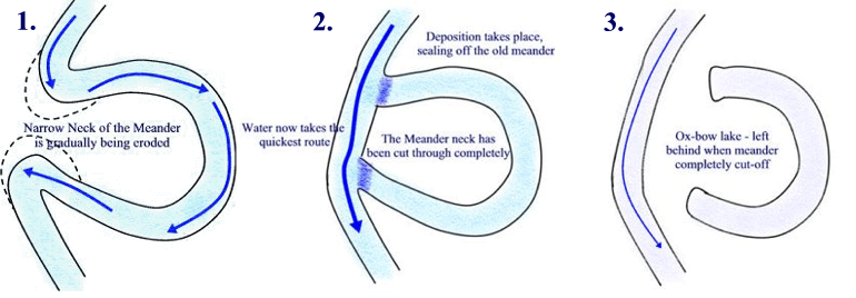
- Meanders and OX bow lakes
- Lower course
- Floodplains and levees
- Formations
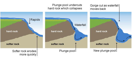
- This is how a waterfall forms
- eanders and OX bow lakes
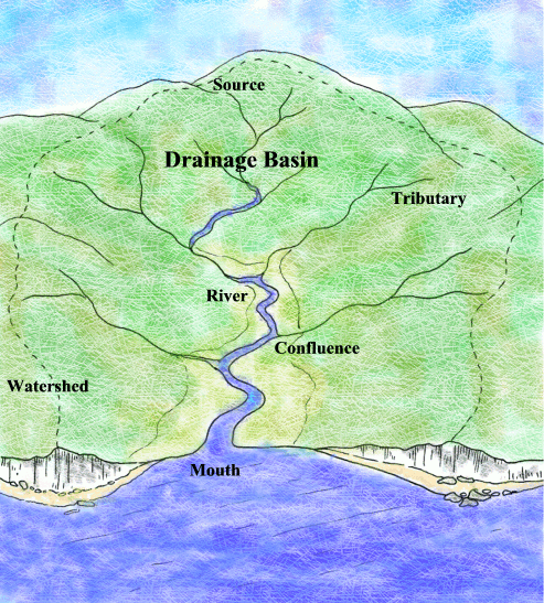
- Drainage basin
- An area of land drained by a river and all of its tributaries
- Factor that can increase or decrease flooding
- Increase
- Steep slopes(means that water travels faster towards the river increase the likelyhood of flooding
- Lack of vegetation/deforestation( there is less trees to intercept the rainfall meaning more of the water enters the river)
- Impermeable bedrock( water can'nt infiltrate into the ground and so more flows over the surface)
- Building on the floodplain
- More impermeable concrete surfaces
- Saturated ground
- Size of a drainage basin
- Drainage basin
- Watershed ( the area of high land forming the boundary and edge of a river basin
- Source( where a river begins)
- Mouth (where a river meets the sea)
- Confluence( the point at which two rivers meet)
- Tributary ( a small river or stream that joins a larger river)
- Channel ( this is where the river flows)
- Drainage basin ( this is the area of land drained by a river and its tributaries
- Increase
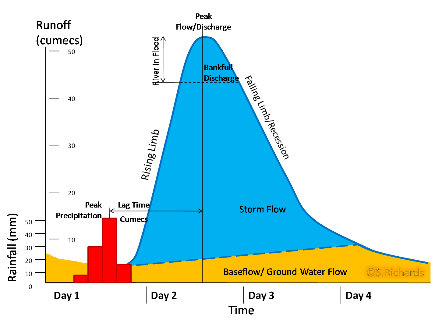
- storm hydrograph
- Shows a rivers response to a particular rainfall event, it shows how quickly the water gets into the river. the quicker the water reaches the river the more likely there is to be a flood event
- Upper coarse
CASE STUDY
- Niagara falls
- People have utilised the waterfall to make a profit from tourism i.e. Hotels,Restaurants,Museums,information centres,Boat rides and Helicopter rides which take full advantage of the tourism)
- ADVAN(creates jobs and improves the economy)
- DISADVAN( are that the falls become overcrowded, the tourist attractions can make it look like a theme park and the tourists can have an environmental impact though erosion,pollution and litter)
- People have utilised the waterfall to make a profit from tourism i.e. Hotels,Restaurants,Museums,information centres,Boat rides and Helicopter rides which take full advantage of the tourism)
- Boscastle
- Contributers to the flooding in boscastle
- Human factors
- Village developed on flat land of floodplain
- Natural channel of river has been walled preventing it from adjusting to variations in discharge
- Natural factors
- Narrow valley with interlocking spurs
- 185mm of rainfall in 5 hours
- Steep valley sides that encourage rapid runoff
- The village as it is at the confluence of 2 rivers
- Human factors
- Monday 16th August 2004
- 60mm of rainfall fell in 2 hours
- The ground was saturated due to weeks of above average rainfall
- Effects
- Short term
- People are homeless and have no access to money within a week of the flood
- Damage caused by river to cars and people other belongings, also includes their homes
- long term
- The pain and anguish of the flood in 2004 may still effect people who lost their homes or treasured percessions
- Fear of more freak floods
- Financial difficulties, as it will take a long time for the insurance companies to pay for the damage caused
- Tourism actually increased in the long term
- Short term
- Contributers to the flooding in boscastle
- Niagara falls
Hard and soft engineering
- Hard
- Artificially trying to alter and control the course of a river
- Usually more expensive
- Not always environmentally friendly
- Less aesthetic
- Can be very effective
- Can cause unforeseen problems further down stream
- Building a DAM to control and regulate water flow
- Building LEVEES to provide protection against flooding
- STRAIGHTENING the river channel to avoid settlement or speed up the flow of water through an area
- WIDENING AND DEEPENING the river channel to increase the amount of water the river can hold
- Soft
- using the natural features of a river to try and control flooding
- Usually cheaper
- More environmentally friendly
- Can be less effective
- AFFORESTATION planting trees to increase the amount of interception and reduce the amount of water entering the river
- PLANNING LAWS the local authority can introduce policies to stop developments being built on the floodplain
- MANAGED FLOODING the river is allowed to flood naturally in some places to prevent it flooding in populated areas
- EARLY WARNING SYSTEMS floodline and flood plans have been set up by the environment agency to prepare residents in flood prone areas
- Hard
Future foolding in the uk
- No. people at high risk of flooding will rise from 1.5 million to 3.5 million
- Cost of flood damage will rise from £1billion a year to £27 billion a year
- Climate change is one of the main cause of the extra flood risk
- 10% of UK homes are on floodplains as new homes need to be built this could increase
- What should be done to reduce this
- Householders encouraged not to pave over gardens, this creates more permeable surfaces in towns and cities
- Block drainage in upland mountain areas and develop more peat bogs to store water. this stores water in the mountains meaning less reaches the river
- Make homes more flood proff by putting plug sockets higher up walls etc
- Restrict building on floodplains
- Invest in flood defence schemes but be weary of hard engineering that can cause further problems downstream
Imagens e arquivos do mapa
Informações
- Descrição
- Geography Mapa Mental sobre Water (rivers), criado por THEGIANT64 em 24-03-2014.
- Criado por
- THEGIANT64
- Visualizações
- 67
- Tags
- Avaliação