
Mapa mental
The Philippines- Disaster Hotspot
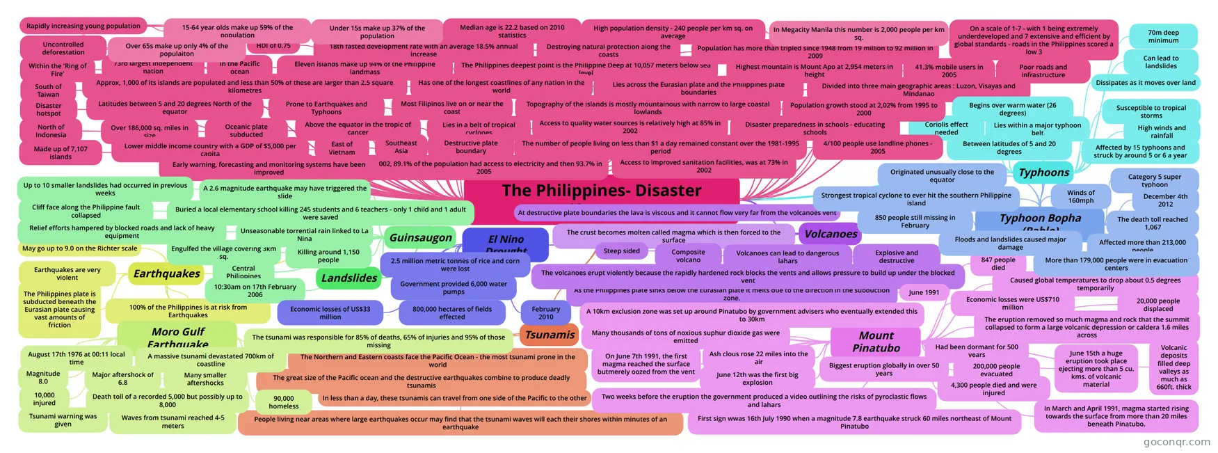
Mind map: The Philippines disaster hotspot
Conteúdo do mapa
The Philippines- Disaster Hotspot
Southeast Asia
Above the equator in the tropic of cancer
Made up of 7,107 islands
Latitudes between 5 and 20 degrees North of the equator
Lies in a belt of tropical cyclones
Lies across the Eurasian plate and the Philippines plate boundaries
Destructive plate boundary
Oceanic plate subducted
In the Pacific ocean
North of Indonesia
South of Taiwan
East of Vietnam
Within the 'Ring of Fire'
Disaster hotspot
Prone to Earthquakes and Typhoons
73rd largest independent nation
Over 186,000 sq. miles in size
Topography of the islands is mostly mountainous with narrow to large coastal lowlands
Divided into three main geographic areas : Luzon, Visayas and Mindanao
Highest mountain is Mount Apo at 2,954 meters in height
The Philippines deepest point is the Philippine Deep at 10,057 meters below sea level
Approx, 1,000 of its islands are populated and less than 50% of these are larger than 2.5 square kilometres
Eleven islands make up 94% of the Philippine landmass
Has one of the longest coastlines of any nation in the world
Most Filipinos live on or near the coast
Earthquakes
- Earthquakes are very violent
- May go up to 9.0 on the Richter scale
- The Philippines plate is subducted beneath the Eurasian plate causing vast amounts of friction
- 100% of the Philippines is at risk from Earthquakes
- Moro Gulf Earthquake
- August 17th 1976 at 00:11 local time
- Magnitude 8.0
- Tsunami warning was given
- Major aftershock of 6.8
- Many smaller aftershocks
- Death toll of a recorded 5,000 but possibly up to 8,000
- A massive tsunami devastated 700km of coastline
- 10,000 injured
- 90,000 homeless
- Waves from tsunami reached 4-5 meters
- The tsunami was responsible for 85% of deaths, 65% of injuries and 95% of those missing
Volcanoes
- Explosive and destructive
- As the Philippines plate sinks below the Eurasian plate it melts due to the direction in the subduction zone.
- The crust becomes molten called magma which is then forced to the surface
- Composite volcano
- At destructive plate boundaries the lava is viscous and it cannot flow very far from the volcanoes vent
- Steep sided
- The volcanoes erupt violently because the rapidly hardened rock blocks the vents and allows pressure to build up under the blocked vent
- Volcanoes can lead to dangerous lahars
- Mount Pinatubo
- June 1991
- Biggest eruption globally in over 50 years
- Had been dormant for 500 years
- First sign wwas 16th July 1990 when a magnitude 7.8 earthquake struck 60 miles northeast of Mount Pinatubo
- In March and April 1991, magma started rising towards the surface from more than 20 miles beneath Pinatubo.
- Many thousands of tons of noxious suphur dioxide gas were emitted
- A 10km exclusion zone was set up around Pinatubo by government advisers who eventually extended this to 30km
- Two weeks before the eruption the government produced a video outlining the risks of pyroclastic flows and lahars
- On June 7th 1991, the first magma reached the surface butmerely oozed from the vent
- June 12th was the first big explosion
- June 15th a huge eruption took place ejecting more than 5 cu. kms. of volcanic material
- Ash clous rose 22 miles into the air
- Volcanic deposits filled deep valleys as much as 660ft. thick
- The eruption removed so much magma and rock that the summit collapsed to form a large volcanic depression or caldera 1.6 miles across
- Caused global temperatures to drop about 0.5 degrees temporarily
- 20,000 people displaced
- 200,000 people evacuated
- 847 people died
- 4,300 people died and were injured
- Economic losses were US$710 million
Typhoons
- Lies within a major typhoon belt
- Susceptible to tropical storms
- Affected by 15 typhoons and struck by around 5 or 6 a year
- Begins over warm water (26 degrees)
- Between latitudes of 5 and 20 degrees
- 70m deep minimum
- Coriolis effect needed
- Dissipates as it moves over land
- Can lead to landslides
- High winds and rainfall
- Typhoon Bopha (Pablo)
- Strongest tropical cyclone to ever hit the southern Philippine island
- Category 5 super typhoon
- Winds of 160mph
- Originated unusually close to the equator
- December 4th 2012
- Affected more than 213,000 people
- More than 179,000 people were in evacuation centers
- The death toll reached 1,067
- 850 people still missing in February
- Floods and landslides caused major damage
Landslides
- Guinsaugon
- Central Philippines
- 10:30am on 17th February 2006
- Cliff face along the Philippine fault collapsed
- Up to 10 smaller landslides had occurred in previous weeks
- Buried a local elementary school killing 245 students and 6 teachers - only 1 child and 1 adult were saved
- Killing around 1,150 people
- Engulfed the village covering 3km sq.
- A 2.6 magnitude earthquake may have triggered the slide
- Unseasonable torrential rain linked to La Nina
- Relief efforts hampered by blocked roads and lack of heavy equipment
- Guinsaugon
Tsunamis
- The Northern and Eastern coasts face the Pacific Ocean - the most tsunami prone in the world
- The great size of the Pacific ocean and the destructive earthquakes combine to produce deadly tsunamis
- In less than a day, these tsunamis can travel from one side of the Pacific to the other
- People living near areas where large earthquakes occur may find that the tsunami waves will each their shores within minutes of an earthquake
Lower middle income country with a GDP of $5,000 per capita
18th fasted development rate with an average 18.5% annual increase
HDI of 0.75
Uncontrolled deforestation
Destroying natural protection along the coasts
Population has more than tripled since 1948 from 19 million to 92 million in 2009
Population growth stood at 2,02% from 1995 to 2000
Rapidly increasing young population
- 15-64 year olds make up 59% of the population
- Under 15s make up 37% of the population
- Over 65s make up only 4% of the populaiton
Median age is 22.2 based on 2010 statistics
High population density - 240 people per km sq. on average
- In Megacity Manila this number is 2,000 people per km sq.
On a scale of 1-7 - with 1 being extremely underdeveloped and 7 extensive and efficient by global standards - roads in the Philippines scored a low 3
By 2002, 89.1% of the population had access to electricity and then 93.7% in 2005
Poor roads and infrastructure
41.3% mobile users in 2005
4/100 people use landline phones - 2005
Access to quality water sources is relatively high at 85% in 2002
Access to improved sanitation facilities, was at 73% in 2002
The number of people living on less than $1 a day remained constant over the 1981-1995 period
Disaster preparedness in schools - educating schools
Early warning, forecasting and monitoring systems have been improved
El Nino Drought
- February 2010
- 2.5 million metric tonnes of rice and corn were lost
- 800,000 hectares of fields effected
- Economic losses of US$33 million
- Government provided 6,000 water pumps
Informações
- Descrição
- A-Levels Geography (World at risk) Mapa Mental sobre The Philippines- Disaster Hotspot, criado por Jodie Goodacre em 01-05-2013.
- Criado por
- Jodie Goodacre
- Visualizações
- 426
- Tags
- Avaliação