
Mapa mental
Uk Climate
Conteúdo do mapa
Uk Climate
Climate variations in the UK
- Temperature
- Warmest region - the south - the sun is higher in the sky resulting in more hours of daylight here than in the north, therefore receiving more insolation here.
- Reduced insolation with altitude - At higher altitudes the molecules are wider and more spread out resulting is less heat being held (colder). Temperatures drop by around 6.4° every 1000m gained in height. The north which is very mountainous is therefore colder than the south.
- Coolest region - north/south uplands - As the prevailing wind travels from the opposite direction (south west) by the time the wind reaches the north it will have lost most of the heat energy picked up from the Atlantic ocean resulting in cooler tempratures.
- Coastal regions are cooler in the summer (as water has a higher heat capacity so takes longer to heat up) as cool surface winds blow from the sea to the land. In the winter the coastal regions are warmer than those inland (water's higher heat capacity means it can retain heat for longer) as warm winds blow from the sea to the land.
- Percipitation
- Wettest area - The west - due to the south westerlies bringing warm, wet air (from surface water) from the Atlantic ocean. The air that reaches the west of the UK is then forced upwards over the land where it cools and condenses, falling as precipitation (relief rainfall).
- The west and north of the UK is more mountainous than the east, the air masses lose most of their moisture in the areas with higher altitude therefore the areas to the east of the mountains experiences less rain, this is known as the rain shadow.
- Rain shadow: The areas to the east of the mountainous regions which experiences less rainfall due to the air holding less moisture here.
- Wind Speeds
- Strongest winds - in the west - due to the south westerly surface winds blowing over the ocean (the ocean is flat so the wind can gain more energy and pick up speed, compared to on land where there's more obstructions).
- Winds increase strength with altitude - Upland areas experience stronger winds as there are more obstacles (ie. mountains)
- The prevailing wind blows from the South West, originating from the Gulf stream so it brings warm winds.
- The climate is a result of the latitude and location of the UK - Latitude (the UK is located around 50° - 55°N so it doesnt get very hot as then suns never that high in the sky, nor does it get very cool as there is always several hours of daylight. Atmospheric circulation (the UK is on the edge of the ferrel cell so expericences surface winds which bring warm air from the south which rises - creating low pressure and forming depressions). Gulf stream (makes the UK warmer than many places at the same altitude (the Gulf stream brings warm surface air from the Atlantic warming the land). Maritime location (As the UK is surrounded by water, the sea influences the temperature of the land, cool winds blowing from the sea to the land cools the coastal regions (inland regions warmer) and warm winds blowing from the sea to the land warms the coast in winter(inland areas are cooler.
- Temperature
Cimate: the weather conditions prevailing in an area in general or over a long period.
Weather: the state of the atmosphere at a particular place and time as regards heat, cloudiness, dryness, sunshine, wind, rain, etc.
The UK's climate - The Uk's climate is temperate (cool, wet winters and warm, wet summers). The temperature varies with the seasons with it being colder in the winters and hottest in the summer with a temperature range between 5° (Jan) and 20° (August). Rainfall is fairly high all year however varies with seasons - higher in autumn/winter, lower in spring/summer. The prevailing wind comes from the South West and the winds the UK experiences are mostly from the warm south westerlies and cold north winds.
Air Masses that affect the UK
- Artic Maritime - Very cold, wet air - causing rain and cold weather. Forms over Greenland and the Artic ocean. Good visibility all year round.
- Polar Continental - Cold, dry air - very cold, dry weather. Forms over Siberia. Moderate/poor visibility.
- Tropical Continental - Warm, dry air- hot, dry weather (heatwave conditions). Forms over North Africa. Only occurs in summer (when sub-tropical high pressure moves north). Upper levels may become unstable creating thunderstorms.
- Tropical Maritime - Warm, wet air - warm weather and rain. Forms over the Atlantic (where the Gulf stream is located). Poor visibility. Typically forms the warm air behind a warm front in a depression. UK's prevailing wind (SW)
- Polar Maritime - Cold, wet air - cold, rainy weather. Forms over the North Atlantic ocean. Creates cool conditions throughout the year. Good visibility. Typically forms the colder air behind a cold front in a depression.
- Maritime - Wetter (form over water, high water vapour content), Continental - Drier (formed over the continents, low water vapour content)
- Artic/Polar - Colder (formed at higher latitudes), Tropical - Warmer (formed at lower latitudes)
Anticyclones
- Anticyclone: A high pressure weather system caused by a large mass of falling air. They cause extreme weather ie. heatwaves in the summer and freezing weather in winter. They can sit over the UK and remain there for days ('blocking')
- Winter weather
- Very low daytime temperatures (from below freezing to 5°) as sun is at a low angle
- Very cold night-time temperatures (below freezing) with frosts (clear skies (no cloud cover) allows heat to escape through radiation)
- Low level cloud may linger and radiation fogs form overnight.
- Radiation fog: Occurs in winter.As the ground cools (due to radiation of heat from Earth's surface) moisture in the air near the ground condenses (when it reaches it's dew point). It may persist all day or be dispersed by an increase of wind speed or an increase of temperature causing evaporation.
- High levels of atmospheric pollution in urban areas - pollutants are trapped by temperature inversions. Lack of wind means pollutants aren't dispersed.
- Temperature inversion: Caused when the air at higher altitudes is warmer then the air at lower levels. In valleys - upper slopes chill quicker so the cold air moves down the valley slopes as it's denser, forcing the warm air upwards.
- Summer weather
- Very hot and sunny (above 25°) with no rain (no clouds leading to intense insolation)
- Warm night-time temperatures (not falling below 15°) and rapid radiation can cause temperature inversions, morning dew and mist (will disperse quickly)
- After several days there's a risk of thunderstorms due to the large amounts of rapidly rising warm air
- Coastal areas - may get fogs and strong breezes. Highlands could experience strong winds (due to heating of valley sides) causing a pressure gradient
- Anticyclone formation - Air from the upper atmosphere falls, heating as it does so, decreasing the humidity (air masses can hold more water vapour when they're warmer). This leads to a lack of cloud development and dry conditions.
Depressions
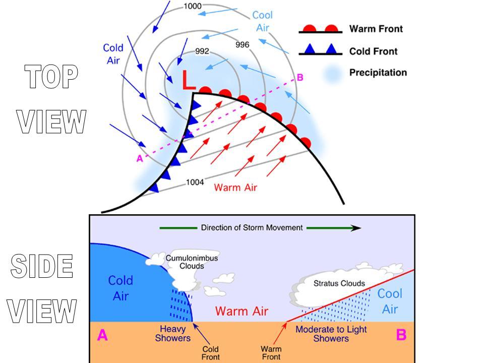
- Formation of a depression - 1. Cold air at the polar regions moves towards the tropics (cold front) and the warm air from the tropics moves towards the poles (warm front) 2. When the two air masses meet the warmer air rises as it is is less dense than the cold air. 3. Rising warm air means the atmospheric pressure is reduced (the low of the depression) 4.Strong winds from the surrounding areas of high pressure to blow towards the low pressure area and so the system rotates as air continues to rise. 5. The cold air moves more quickly than the warm front so eventually cathes up. 6. The warm air is then undercut by the cold air and pushed up, this means it is sitting above the cold air (occuled front) where it'll raise into the upper atmosphere causing the depression to die out (no low pressure area anymore.
- 1.
- 2.
- 3.
- 4.
- 5.
- Depressions: A low pressure weather system that forms over the Atlantic ocean and travels over the UK from west to east. They form when polar maritime and tropical maritime air masses meet.
- 1.Weather ahead of the warm front - Cool weather (cold air is overhead), thin cirrus clouds form as warm air rises and pressure falls. Wind speed increases.
- 2.Weather when warm front is overhead - Warmer weather (warm air is rising above cold air), thicker nimbostratus clouds form (steady drizzle) as warm air rises and pressures falls even more (low of the depression). wind speed is strong.
- 3.Weather when warm air is overhead - Weather is warm, no cloud is formed as warm air can hold a lot of water vapour. Wind speed decreases.
- 4.Weather when cold front is overhead - Cold weather, thick cumulonimbus clouds form as warm air is undercut by cold air (sudden rise in pressure) and forced upwards, heavy rain occurs as warm air condenses rapidly. Very strong winds.
- 5.Weather when cold air is overhead - Cold weather (warm air now above cold air), less cloud cover and rain as the uplift of airs decreased so no condensation occurs. Pressure ries as the dense cold air replaces the warm air (depression dies out). Wind speed decreases.
- Formation of a depression - 1. Cold air at the polar regions moves towards the tropics (cold front) and the warm air from the tropics moves towards the poles (warm front) 2. When the two air masses meet the warmer air rises as it is is less dense than the cold air. 3. Rising warm air means the atmospheric pressure is reduced (the low of the depression) 4.Strong winds from the surrounding areas of high pressure to blow towards the low pressure area and so the system rotates as air continues to rise. 5. The cold air moves more quickly than the warm front so eventually cathes up. 6. The warm air is then undercut by the cold air and pushed up, this means it is sitting above the cold air (occuled front) where it'll raise into the upper atmosphere causing the depression to die out (no low pressure area anymore.
Imagens e arquivos do mapa
Informações
- Descrição
- A level Geography (Weather & Climate) Mapa Mental sobre Uk Climate, criado por Natalie Bond em 17-05-2017.
- Criado por
- Natalie Bond
- Visualizações
- 5
- Avaliação