
Mapa mental
GIS
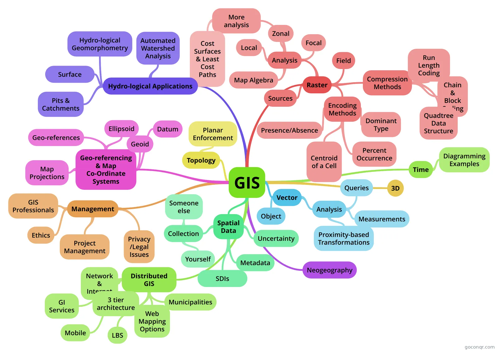
Mind map: GIS
Conteúdo do mapa
GIS
Geo-referencing & Map Co-Ordinate Systems
- Geo-references
- -How locations are determined Common types: -place names -postal codes -linear references -co-ordinates
- A geo-reference must be: 1-Unique (links to exactly one location) 2- Understood (so different users understand the meaning of a geo-reference) 3- Consistent (same projection is used for all map layers) 4- Persistent (through time, so today's geo-references are still meaningful tomorrow)
- Ellipsoid
- A reference surface for horizontal measurements
- Geoid
- A reference surface for vertical measurements-ellipsoids don't take into account for the Earth's complex topography - A equipotential surface based on gravitational irregularities
- Datum
- 'a system for anchoring an ellipsoid to known locations on the Earths surface
- Map Projections
- Mathematical formula to transform the curved surface of the Earth onto a flat map
- Geo-references
Vector
- Object
- Implementation of the object model of spatial data Object: - discrete spatial features - each object has precisely defined spatial boundaries, buildings, roads, lakes -represented in the DB through points, lines & polygons - these are generally things we can see on the landscape
- Analysis
- Queries
- Queries do not change existing data sets or create new data by combining existing data sets
- Measurements
- Distance Length or PerimeterArea ShapeRatio of perimeter to the square root of area Volume
- Proximity-based Transformations
- Buffering Overlays
- The point in polygon algorithm - a point inside a polygon has a odd number of crossings - a point outside a polygon has an even number of crossings
- Overly issues -Spurious polygons (sliver polys) -Complexity of output map layers -Dissolving adjacent polygons (spatial aggregation) to solve these issues
- Queries
- Object
Raster
- Regular tessellation of cells -Represents fields by assigning attribute values to cells
- Raster model is generally much better for modeling continuous features than vector and performing analyses that involve spread, flow, or diffusion processes
- It is relatively easier to understand as a method of representing spatial features and processes and is usually computationally faster and simpler than vector
- Field
- -have properties that vary continuosly over space eg elevation, temperature, noise
- Encoding Methods
- Presence/Absence
- This involves recording what you want into the cell. If a feature of interest is found within a cell, code the cell to reflect the presence of that feature and ignore all other features
- Centroid of a Cell
- Presence of an entity is recorded only if a portion of it occurs directly at the central point of each cell Appropriate for continuous data such as elevation, temperature
- Dominant Type
- Encodes the presence of an entity if it occupies more than 50% of the cell
- Percent Occurrence
- Identify what feature to record in raster layer (e.g. urban land) If several types of land use occur in a cell, then value of each cell reflects the percentage of the cell that the feature of interest (e.g. urban land) occupies
- Presence/Absence
- Compression Methods
- Run Length Coding
- scan a row, noting each unique cell value and the # of occurrences for each cell value
- Chain & Block Coding
- similar to Run Length Encoding but scans rows & columns to define 2D regions with same cell values
- Quadtree Data Structure
- recursive subdivision of raster cells into quadrants with the same cell value - uses variable cell resolution to reduce data storage requirements
- Run Length Coding
- Sources
- Remote sensing Raster scanning Vector to raster conversion
- Analysis
- Local
- Is the most basic of the associative operations in Raster GIS. These functions produce a new grid where the value of each cell is determined as some arithmetic operation among the values of same-location cells on any number of input layers Boolean statements Reclass: aggregating values to produce new classes
- Overlay -Create new data by combining map layers of different features based on -Combines 2 layers (fields) to produce a 3rd field (layer) f x f ---> f have to have the same # of cells and location
- Reclass - cell by cell operations -neighbouring or distant cells have no effect on the output grid values -local operations include: -reclassification (assign a new value to each unique value on the input layer) f--->f scalar -overlay
- Zonal
- This means of association produces a new grid of zones that summarize the values of a raster grid over the areas covered by the zones in a zone grid. Operation on groups of cells
- Focal
- This class of associative functions evaluates a new grid by summarizing statistics in the neighbourhood around each cell. This may be on the same or a different layer
- Surface Analysis Functions: associations of cells in a raster of elevations, a DEM, can be analysed to calculate slope & aspect
- Filtering -moving window that is passed across the entire raster Slope and aspect derivation uses a method similar to filtering
- Viewsheds: a surface that represents the field of view across a study area from a given location, calculated from a DEM
- Map Algebra
- input raster layer(s) ---> [operation] ---> output raster layer 3 categories: local, focal, zonal
- More analysis
- Inverse Distance Weighting- assumption that space is correlated -values nearby are not independent, and this correlation may be used to support the prediction of values at nearby sites Weighted Distance Buffers -can reflect differences in 'cost of distance' using a 'friction'surface -Resultant buffer will be wider in areas of low friction and narrower where cells represent higher friction values If moving straight across, it is a cost of 1*the cost of the cell itself. Or if moving diagonally, it is 1.414* the cost of the cell itself.
- A surface is a continuous field of values over an infinite number of points eg elevation, temp, concentration of a chemical
- Independence and Spatial Correlation- consider dependence between nearby points in space, a sample that occurs near in space is likely to be more similar than one that is further away (aka auto-correlation)
- Cost Surfaces & Least Cost Paths
- Cost Surface represents the total 'cost'of travelling overland from one or more starting points 1 - Generate a Friction Surface --absolute barriers- you cannot travel through that cell --relative barriers- you can pass through cell, but incur travel costs 2- Create an accumulated cost surface from the point(s) of origin to the destination cell(s) 3- Create a least cost path across the accumulated surface from origin to destination
- Local
Spatial Data
- Data is the foundation of a GIS It determines: -what theme - what types of analysis -where -when - quality of your analysis
- Collection
- Someone else
- Buy it from vendors- government or commercial Get it from free websites Data sharing agreements
- Yourself
- -Primary- collection of raw data from direct measurement in the field, eg GPS, Surveying, Remote Sensing -Secondary - data derivation from other sources -Hardcopies (scanning or digitizing) -Digital copies (data model or format conversion)
- Someone else
- Metadata
- Data about data Describes the identity, extent, quality, spatial and temporal schema, origin, condition and many other characteristics
- It can come in many forms: file headers, XML documents, data dictionaries & definitions, time date and authorship
- It adds value to an already valuable resource
- SDIs
- Spatial Data Infrastructure - a relevant base collection of technologies, policies & institutional arrangements that facilitate the avaliability of and access to spatial data. An SDI provides a basis for spatial data discovery, evalutaion, and application for users and providers.
- Uncertainty
- Has 3 components: Error: the known uncertainty due to systematic and human limitations (chief uncertainty) Vagueness:uncertainty associated with a spatial or attribute & concept eg boundary or density Randomness: the component of of uncertainty that despite minimised error it cannot be modelled eg Human error or GPS signal affected by atomsphere
- Error: accuracy( how close to the recorded data values are to the 'true'value precsion: interpreted in terms of how 'exact' data measurement & storage area aka as we repeatdly collect data for a point, how precise we are
- Sources of Positional Error - map projection, datum & their parameters...as soon as you use an ellipsoid/geoid there will always be some kind of error - primary measurement error - error determining location of features - instrument or human error...humans operate the instruments & they all have a range of skill levels -secondary data acquisition errors- digitizer/scanner resolution - media, quality of source maps & photos (the older it is, the more time has elapsed to distort that media) - operator, registration/interpretation error...friday afternoons -improper representation or conceptualisation of objects or phenomena- scale effects, resolutions, data model effects
- Screen or “heads-up” digitizing - digitizing features on computer screen based on digital orthophotos, it is relatively easy, but not as accurate as table digitizing
- Attribute Error:
- Modifiable Areal Unit Problem
Topology
- Branch of maths that describes the geometric relationships among objects that remain constant when the objects are subjected to certain types of geometric transformations
- Planar Enforcement
- A set of rules used to define a consistent method of building point, line and polygon features from spaghetti-digitized data. For example, planar enforcement includes rules that polygons of differing soil types cannot overlap, and that lines must be split at intersections.
Management
- GIS Professionals
- Must be educated Must follow ethical behaviour Should continue with their education In order to become a GISP, they are submitted for review
- Ethics
- Unethical behaviour involves: -lying with maps -using GIS to plan/support war -using GIS as a surveillance tool -plagarism
- Privacy /Legal Issues
- The need for ready availability of information for the social and economic benefit of the community; vs. The responsibility to ensure that the rights of individuals and groups are not infringed by abuse of that information. e.g. In e-commerce, consumers’ private and personal information is subject to collection, storage, manipulation and analysis using: Cookies, Personal digital certificates, Customer tracking systems, Mass customization and personalized marketing, Dynamic content servers, DBMS and data mining
- Copyright (protects the expression of an idea) Trade Secrets(confidential info-providing a competitive advantage) Patents (protects the idea itself) Trademarks- word or symbol used to distinguish the wares or services of an organization from other
- Project Management
- Investigation Analysis Documentation Critical Appraisal & Review Presentation
- RFPs You have to convince the client that you are the best for the job. Tips: -Take notes of what they are actually requesting Elements such as ToC and clear structure Diagrams + figures preferable to lots of text Do not give away too much Contingencies: inflate the price by 10-15%
- GIS Professionals
Hydro-logical Applications
- Hydro-logical Geomorphometry
- Geomorphometry is the quantitative science of land surface analysis Inputs: DEMs Methods: Image Analysis, Statistical, Mathematical, Algorithmic Outputs: -surface parameters & objects
- Surface
- The land surface could be theoretically be described by a function of x & y (N,E)
- Flow direction -Direction in which water will flow -The direction of steepest descent -Similar to aspect
- Pits & Catchments
- Local minima in the surface -Raster: cells with no lower neighbours
- A catchment is the region contributing flow to a single outlet point Usually depicted as a polygon or contiguous region of a nomial raster values A basin is the catchment of a pit The lowest point on the perimeter of a basin is the pour point, and so is the outlet. A basins pour point is the point where pits will overflow
- Automated Watershed Analysis
- Take a DEM ---> Fill sinks---> Determine flow direction---> Determine flow accumulation---> Determine watersheds
- Hydro-logical Geomorphometry
3D
- 'the natural choice, as its how we see the world"
- Isarithmic Map- depicts continuous smooth phenomena such as precipitation or elevation 2.5D ArcGIS ArcScene- is a 3D vizualization app that allows you to view your GIS data in 3D Building & Texturing- you can use various apps to do 3D modelling like GoogleSketchUp, ESRI CityEngine
Time
- It is unidirectional Yet it has no obvious physical form or properties, so it is difficult to conceptualise Can be absolute (6/06/2014, 1:50pm) or relative (In lecture time slot 5 aka 12pm Time really hasn't received much attention in GIS until recently, this may be due to GIS databases being designed to handle static not dynamic situations
- Time data is stored as separate events in a GIS. There are 3 approaches to event representation Datestamps: time recorded when an attribute changes, this means that the history of a single object can be selected & ordered. Timeslices: separate layers used to represent passing time, this is the most common way to represent time in a GIS Timeline: timeslices into single dataset DBMS enabling temporal queries aka Spacetime composites
- Diagramming Examples
- OpenSim Demo Static Time Mapping- Cartograms- map of London underground, you can click on any staion and it morphs the map into travel time, rather than distance (can literally turn time into space) Time Geography Constucts - lifeline represents where we go in the day, a station is a location, domain represents a land area and a prism is the potential for movement.
Distributed GIS
- User, software, hardware and data can all be in different places, accessed via a network. Data in the cloud, client and server interaction with the desktop and mobile GIS
- Network & Internet
- Moving/moved away from desktop GIS delivery, to it being delivered from a remote server. This means it can handle concurrent access
- 3 tier architecture
- Clients are situated at the top Middleware is in the middle Server is at the bottom
- File-based doesn't handle large amounts of info well The DBMS Oracle cant directly talk to ArcGIS, so it has to use the middleware ArcSDE
- Municipalities
- Local government authorities- it is the most persuasive force in the industry - in charge of land management, zoning, property evaluation, road & asset management, emergency response
- Web Mapping Options
- There is a limited number of options & the commercial industry is dominated by ArcGIS, though a few use AutoDesk-MapGuide
- There are also plenty of non-commercial opensource tools
- GI Services
- 'replaces a local GIS function with one provided remotely by a server'
- Mobile
- Devices have become more compact & mobile in recent years
- Issues -Egocentric Context - the location of the user is important -Limitations of the display due to its small size' -Certain environments unsuitable for certain media -Battery life is limited -Wifi/3G issues -Security
- LBS
- Location Based Services - information that it spatially fixed and can be delivered to network devices... “A location-based service (LBS) is an information service provided by a device that knows where it is and is capable of modifying the information it provides based in that knowledge"
Neogeography
- Neogeography (literally "new geography") is the use of geographical techniques and tools for personal and community activities or by a non-expert group of users
Informações
- Descrição
- SURV 208 Mapa Mental sobre GIS, criado por lucystulen em 05-06-2014.
- Criado por
- lucystulen
- Visualizações
- 31
- Avaliação