5847483
Descrição
Quiz por tsampikos pompou, atualizado more than 1 year ago
|
|
Criado por tsampikos pompou
quase 8 anos atrás
|
|
Questão 1
Questão
432 When tracking the R-245 radial inbound to a VOR station, for the course deviation indicator (CDI) to operate in the correct sense, the omni bearing selector (OBS) should be set accordingly to:
Responda
-
O 065.
-
O 245.
-
O 360.
-
O 180.
Questão 2
Questão
433 When maintaining a constant track to an NDB with 8° port drift, the relative bearing indicator (RBI) will indicate:
Responda
-
O 352° relative
-
O 008° relative.
-
O 172° relative.
-
O 188° relative.
Questão 3
Questão
434 Having tuned and identified a VOR, the Omni Bearing Selector (OBS) is set to 285 and a 'FROM' or ΅ indication is produced while the Course Deviation Indicator (CDI) is centred. In relation to the VOR, in which quadrant is the aircraft receiver located?
Responda
-
O 270° - 359°
-
O 360° - 089°
-
O 090°- 179°
-
O 180°- 269°
Questão 4
Questão
435 In middle latitudes, GC direction on a Mercator chart can be obtained:
Responda
-
O Accurately, providing that the GC can be accurately drawn on the chart.
-
O Easily
-
O Not at all
Questão 5
Questão
436 On a standard Mercator chart, no complete GC is a straight line
Responda
-
O This is true with one important exception
-
O This is true
-
O This is false
Questão 6
Questão
437 On a standard Mercator chart GC are curves, concave to the:
Responda
-
O Equator
-
O Arctic region
-
O North polar region
-
O South polar region
Questão 7
Questão
438 A Mercator chart is suitable for topographic chart. This is:
Responda
-
O Only for equatorial region
-
O Always wrong
-
O Definitely true with no exception
-
O Only the Polar region
Questão 8
Questão
439 Shapes of areas on a normal Mercator chart are correct:
Responda
-
O Reasonably for small areas in low latitudes
-
O Everywhere applicable
-
O Approximately in high latitudes
-
O Suitable for large area
Questão 9
Questão
444 Spot the place following the coordinates (N38 52΄33" E22 26΄09"). Use the appropriate charts.
Responda
-
O Lamia.
-
O Almyros.
-
O Farsala.
-
O Trikala.
Questão 10
Questão
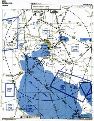
445 (Fig. 10) Blue coloured number 83 near Metsovo, is:
Responda
-
O MEF
-
O MSA
-
O Highest altitude.
-
O Minimum en-route flight.
Questão 11
Questão
446 What means the black coloured triangle ,depicted on chart (Fig, 9), spread around TMA?
Responda
-
O VFR Routes.
-
O A mileage break point.
-
O Intersections.
-
O MRA.
Questão 12
Questão
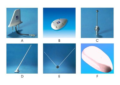
448 Evaluate the antennas illustrated in (Fig.15),mostly used in light General Aviation by size and form?
Responda
-
O Α=DME, B=GPS, Γ=Τransponder, Δ=VHF/Com, E=Nav, F=ADF,
-
O A= VHF/Com, B= ADF, Γ= Nav, Δ= DME, Ε= GPS, F= Τransponder,
-
O Α= Τransponder, Β= GPS, Γ= DME, Δ= Nav, Ε= ADF, F= VHF/Com,
-
O Α= ADF Β= Nav, Γ= VHF/Com, Δ=Τransponder, Ε= DME, F= GPS,
Questão 13
Questão
449 Magnetic track is…
Responda
-
O the true track, corrected for variation
-
O the true track, corrected for drift
-
O the true heading, corrected for drift
-
O the true track, compensated for X-track error.
Questão 14
Questão
450 To comply with departure instructions issued by Makedonia ATC:
" Initially route to Agelo until clear of antenna masts, proceed visually to Delta not above 1500 feet and then climbing to and maintaining the flight plan altitude of 3000 feet."
What should your main altimeter subscale setting be?
Responda
-
O Aerodrome QNH, then once clear of the TMA, set the destination regional pressure. setting.
-
O Aerodrome QNH, then once clear of the TMA, set the standard pressure setting.
-
O Aerodrome QFE, then once clear of the TMA, set the aerodrome QNH.
Questão 15
Questão
451 For a flight from LAMIA to Alexandria (LGAX) the aircraft is cleared after take off to climb from FL 40 clearing the mountains, to FL240 with a mean RAS of 200 kt and mean rate of climb of 2000 ft/min. Forecast winds and temperatures are:
FL 40 240/20 +8 ° C
FL 240 280/40 -26° C
The mean TAS for the climb is
Responda
-
O 252 kt
-
O 265 kt
-
O 275 kt
-
O 240 kt
Questão 16
Questão
452 For a flight from LAMIA to Alexandria (LGAX) the aircraft is cleared after take off to climb from FL 40 clearing the mountains, to FL240 with a mean RAS of 200 kt and mean rate of climb of 2000 ft/min. Forecast winds and temperatures are:
FL 40 240/20 +8° C
FL 240 280/40 -26° C
The flight time for the climb is
Responda
-
O 10 min
-
O 20 min
-
O 6 min
-
O 14 min
Questão 17
Questão
453 For a flight from LAMIA to Alexandria (LGAX) the aircraft is cleared after take off to climb from FL 40 clearing the mountains, to FL240 with a mean RAS of 200 kt and mean rate of climb of 2000 ft/min. Forecast winds and temperatures are:
FL 40 240/20 +8° C
FL 240 280/40 -26° C
What is the distance covered, upon leveling of at FL 240?
Responda
-
O 44 NM
-
O 24 NM
-
O 54 NM
-
O 64 NM
Questão 18
Questão
454 For a flight from LAMIA to Alexandria (LGAX) the aircraft is cleared after take off to climb from FL 40 clearing the mountains, to FL240 with a mean RAS of 200 kt and mean rate of climb of 2000 ft/min. Forecast winds and temperatures are:
FL 40 240/20 +8°C
FL 240 280/40 -26° C
What is the Min Safe Altitude (MSA. for the whole route to destination?
Responda
-
O 11.000 ft
-
O 10.000 ft
-
O 2917 m
-
O 3838 ft and 9551 ft
Questão 19
Questão
455 For a flight from LAMIA to Alexandria (LGAX) the aircraft is cleared after take off to climb from FL 40 clearing the mountains, to FL240 with a mean RAS of 200 kt and mean rate of climb of 2000 ft/min. Forecast winds and temperatures are:
FL 40 240/20 +8 ° C
FL 240 280/40 -26° C
Less than, couple of minutes, after leveling of, you're established over….?
Responda
-
O Larisa
-
O Volos
-
O Katerini
-
O Alexandria
Questão 20
Questão
456 Radio bearings follow…………………..path over the earth?
Responda
-
O GC (Great Circle)
-
O Straight line
-
O Line of sight
-
O Their own particular (depending on wave leagth)
Questão 21
Questão
457 If you request a QDM and the air traffic controller gives you QDM 235o class C, Class C means the bearing is accurate to within
Responda
-
O +/- 10°
-
O +/- 25°
-
O +/- 5 °
-
O none
Questão 22
Questão
458 The letters CDI stands for
Responda
-
O Course Deviation Indicator
-
O Centrally Dividing Indicator
-
O Compass Direction Indicator
-
O CD Category I.
Questão 23
Questão
460 On the ICAO 1:500.000 chart, in each quadrangle bounded by half intervals of latitude, is a two figure number printed in blue, with the first figure larger than the second. What does it represent.
Responda
-
O The maximum elevation figure (MEF) in hundreds of feet, AMSL. This is not a safety altitude.
-
O The maximum elevation figure (MEF) in hundreds of feet, AMSL, which is a Safety altitude.
-
O A safety altitude in thousands of feet.
-
O Relative altitude in thousands of feet.
Questão 24
Questão
461 You are airborne at 1208 UTC and set course overhead LAMIA-Army at 12:10 UTC. What is the expected time of arrival to Megara (LGMG) TAS=85, W/V 055°/15
Responda
-
O 13:00
-
O 13:02
-
O 12:10
-
O 12:58
Questão 25
Questão
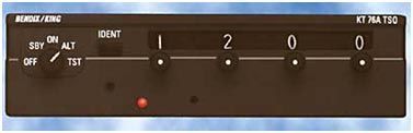
462 On the SSR control unit (Fig.7) set to ALT, equipment responds to:
Responda
-
O mode ''A'' and ''C'' signals together
-
O mode ''A'' signals with the selected mode
-
O mode ''C'' signals with the a/c flight level
Questão 26
Questão
463 DME (Distance Measuring Equipment) uses the principles of radar to measure …………….distance.
Responda
-
O slant
-
O vertical
-
O horizontal
Questão 27
Questão
464 What is the distance from Thess-Makedonia (LGTS) to Angello pt when a Cessna 172 flies outbound and establishing in 4 min ground speed 85 knots.
Responda
-
O 5,7 NM
-
O 60 NM
-
O 0,57 NM
-
O 57 NM
Questão 28
Questão
465 What is the distance from LGSD to LGTS, when a Cessna 152 flies from one aerodrome to another in 2 ½ min. and having a ground speed of 70 knots.
Responda
-
O 2,9 NM
-
O 0,35 NM
-
O 3,5 NM
-
O 0,29 NM
Questão 29
Questão
466 Using the ETE of 2h from PAPHOS (LCPH) to Rodos-Diagoras (LGRP) and assuming a fuel consumption of approx 5 Imp. gallons per hour, plus a fuel compelled reserve of 6 Imp. Gallons overhead Rodos what is the required fuel in liters for that leg?
Responda
-
O 72,5 LT
-
O 27,3 LT
-
O 60,5 LT
-
O 22,7 LT
Questão 30
Questão
467 The letters VOR stand for:
Responda
-
O VHF omni-directional radio range.
-
O Variable omni-range
-
O Vissualy observed radial
-
O Variable omni-receiver.
Questão 31
Questão
468 ADF reception may be affected by:
(i) night effect
(ii) atmospheric static
(iii) terrain surrounding the station
(iv) aircraft altitude
(v) the height of the NDB station
The correct combination of the statement is:
Responda
-
O (i),(ii) and (iii)
-
O All the mentioned.
-
O (iii),(iv) and (v)
Questão 32
Questão
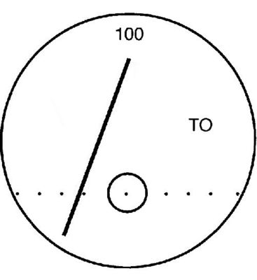
469 The VOR display featured in Fig.8, gives you a X-track error of:
Responda
-
O 4°
-
O 2°
-
O 6°
-
O 8°
Quer criar seus próprios Quizzes gratuitos com a GoConqr? Saiba mais.