
Quiz
11/12
Create a free account to finish this quiz
Save your progress and see your final score.
Already have an account? Sign in
Questions in this quiz (23)
1Why is the eye region of a hurricane largely free of precipitation and heavy clouds?
- Asinking air motion
- Brising air motion
- Cpressure gradient is weaker
- Dcooler temperatures
2What general circulation wind belt is the place of origin for hurricanes?
- Awesterlies
- Btrade winds
- Cdoldrums
- Dhorse latitudes
3When the upper-air exhibits a general ________ flow, cyclonic systems tend to move through quickly, creating rapidly changing weather conditions.
- AW to S
- BN to S
- CN to E
- DW to E
4You'd like to plan a Christmas day flight to visit family. You have several months lead time. How might you determine the probability of snowfall occurring and potentially interfering with your travel plans?
- Aconsult a climatological forecast
- Bwatch the weather forecast
- Crefer to the an along forecast
- Droll the dice
5Which of the following rely on the fact that gases of the atmosphere obey a number of known physical principles to predict the future state of the atmosphere?
- Anumerical weather prediction
- Bstatistical methods
- Ctrend forecasting
- Dpersistence forecasting
6These types of images are views of the earth the way an astronaut would see our planet from space.
- Ainfared images
- Bvisible images
- Cmoon images
- Dwater vapor images
7The acronym NOAA stands for:
- ANational Oceanic and Atmospheric Administration.
- BNational Observatory for Atmospheric Assessment.
- CNightly Observation of Atmospheric Attributes.
- DNumerical Observation Assessment Association.
- ANational Oceanic and Atmospheric Administration.
8Cyclone Nargis made landfall in:
- ABangladesh
- BMyanmar
- CAustralia
- DJapan
9Why are most weather data displayed in the form of a map or chart?
- Amore data can be recorded on a map
- Bmaps are easier to remember
- Cmaps display the data in their proper place, relative to other data, and allow the identification of patterns
- Dmaps are easier to construct than tables
10________ predict(s) that future weather will be the same as the present weather conditions.
- Athe analog method
- Bpersistence forecasts
- Ctrent forecasting
- Dnowcasting
11What is the current air temperature represented on the station model shown above?
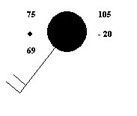
- A75 F
- B75 C
- C69 F
- D-20 C
12The forecasts for local and regional weather are produced by:
- Aweather forecast offices
- Bnational cyclone center
- Cstate weather forecast offices
- Dnational centers for environmental prediction
13When a cyclone's strongest winds do not exceed 37 miles per hour it is called a:
- Atropical depression
- Btropical storm
- Ctornado
- Dhurricane
14As a strong hurricane moves ashore, which of the following causes the most devastating damage in the coastal zone?
- Astorm surge
- Bstrong winds
- Ctorrential rains
- Dlightening
15Why do surface wind speeds increase toward the center of a hurricane?
- Areduced friction
- Bstronger coriolis effect
- Cconservation of angular momentum
- Dwarmer water
16What system is used to name hurricanes if the established list of names is exhausted in a given year?
- Alatitude/longitude
- Bthe greek alphabet
- CUS presients
- Droman numerals
17When occurring in the Atlantic Ocean they are known as hurricanes. What are they known as when occurring in the western Pacific?
- Atyphoons
- Btropical breezes
- Ctsunamis
- Dcyclones
18What determines when a tropical depression or storm is given hurricane status?
- Awater temperature
- Bwind speed
- Cdiameter
- Dcentral pressure
19Long range forecasts (monthly or seasonal) include predictions of:
- Apressure
- Btemperature
- Cprecipitation
- Dtemperature and precipitation
20Since detection and tracking of hurricanes is now quite accurate, why does damage from these storms continue to increase?
- Acontinued development of coastal areas
- Bpoor forecasts of landfall area
- Cchanges in tidal patterns
- Dhurricane intensity is greater
21Hurricanes form
- A35-50 degree latitude
- B20-35 degree latitude
- Cat the equator
- D5-20 degree latitude
22Why are some satellites described as being stationary?
- ATheir orbital motion matches the earth's rotation.
- BThey orbit over the earth's poles.
- CThey have no orbital motion.
- DThey can only observe stationary weather systems.
- ATheir orbital motion matches the earth's rotation.
23Upper-air maps are commonly drawn for all the following pressures, except:
- A500 mb
- B700 mb
- C850 mb
- D1000 mb
Information
- Description
- Quiz on 11/12, created by astrass132 on 09/12/2014.
- Author
- astrass132
- Language
- English
- Views
- 2
- Rating
- No ratings yet Rate this quiz