4379391
AS coasts revision
Description
Slide Set by Katy Holmes, updated more than 1 year ago
More
Less
|
|
Created by Katy Holmes
over 8 years ago
|
|
Resource summary
Slide 1
Coasts revision
ContentsThe coastal systemCoastal processesLandforms produced by coastal erosionLandforms produced by coastal depositionSea level changeCoastal floodingCoastal protection schemesGreen= Key terms
Slide 2
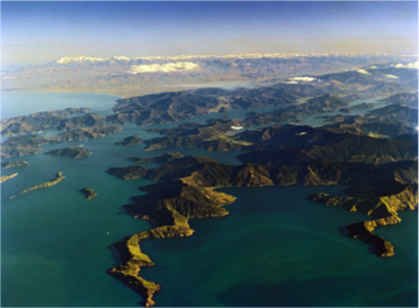
Coastal systems
Like rivers coasts also have systems.INPUTS- River sediment, sediment from cliffs that have been eroded or suffered landslides and sediment that has been transported by waves from offshore.PROCESSES- wave action, tidal movement, erosion, weathering, transportation and depositionOUTPUTS- Sediment washed out to sea or deposited further along the coastCoastal sediment cells also known as littoral cells are lengths of coastline that are pretty much entirely self-contained for the movement of sediment. Each one is a coastal system. So processes going on in one cell don't affect the movement of sediment in another cell.
Slide 3
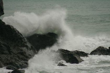
Waves
A wave is created by the wind blowing over the surface of the sea, this friction causes the water to move in a circular motion.The effect of a wave on shore depends on the height, this is affected by wind speed and fetch. As waves approach the shore they break. Friction with the sea bed slows the bottom of the waves and makes their motion more elliptical, the crest of the wave rises up and then collapses.Tides are the periodic rise and fall of the ocean surface, they are caused by the gravitation pull of the moon and the sun.
Slide 4
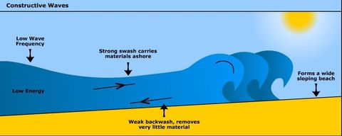
Constructive waves
Constructive waves:
Have low frequency around 6-8 waves per minute
low and long
Elliptical cross profile
Powerful swash
Creates beaches
Slide 5
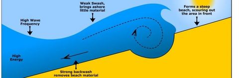
Destructive waves
Destructive waves are:
High and steep
Circular cross profile
High frequency 10-14 waves per minute
Powerful backwash
Erodes beaches
Slide 6
Sub aerial weathering
This describes the coastal processes that are not linked to the action of the sea, it includes freeze thaw weathering and salt weathering.Throughflow and runoff caused by heavy rain can also make cliffs more unstable and increase the likelihood of mass movement.Mass movement is the movement of material downhill due to gravity. It includes, landslides, slumping and rockfalls.
Slide 7
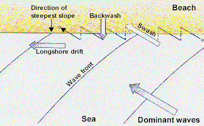
Erosion and long shore drift
The rate at which a stretch of coastline is eroded depends on several factors.The width of the beach- the distance between high and low tide marks. Beaches slow down waves, reducing their erosive powers.The breaking point of the waves- a wave that breaks at the foot of a cliff transfers most energy to the cliff and causes erosion. Waves that hit the cliff before they break will erode mush lessThe aspect- If the coastline faces the dominant wind and wave direction erosion will be fasterThe fetch- waves with a long fetch are higher and steeper with more energyRock type- soft rocks like clay will erode quicker
Caption: : Long shore drft
Slide 8
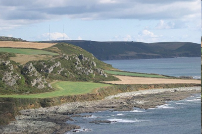
Coastal landforms
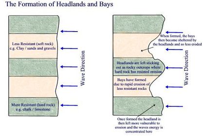
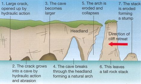
Cliffs and wave cut platformsCliffs retreat due to the action of waves and weathering.This causes a notch to form at the high water mark, this develops into a cave. Rock above the cave becomes unstable and so it collapses. Wave-cut platforms are flat surfaces when a cliff is eroded.Headlands and baysThey form when there are bands of alternating hard rock at right angles to the shore. The soft rock is eroded quickly forming a bay. The harder rock is eroded less and sticks out as a headland.
Slide 9
Coastal landforms
Caves, blowholes, arches and stacksWeak areas in rock eg joints are eroded to form caves.Occassionally the roof of a cave is weakened along a major joint by hydraulic pressure and the roof collapses to form a blowhole. Caves on the opposite sides of a narrow headland may eventually form an arch. When an arch collapses it forms a stack.
Slide 10
Coastal landforms
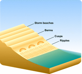
BeachesThey are formed when constructive waves deposit sediment on the shore. Shingle beaches are steep and narrow. They're made up of largeer particles which pile up at steep angles, sand beaches are wide and flat.Berms are ridges of sand and pebbles found at high tide marks. They're formed by deposition of coarse material at the limit of the swash.Runnels are grooves in the sand running parallel to the shore they are formed by backwash draining to the sea.Cusps are crescent shaped indentations that form on beaches of mixed sand and shingle they develop in areas where waves break parallel to the beach and where there's a large tidal range.
Slide 11
Coastal landforms
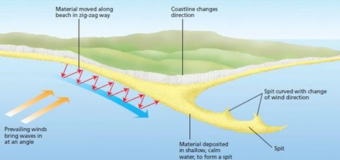
Spits tend to form where the coast suddenly changes direction.
Longshore drift continues to deposit material across the river mouth leaving a bank of sand and shingle sticking out into the sea
Occasional changes to the dominant wind and wave direction may lead to a spit having a recurved end
Over time several recurved ends may be abandoned as the waves return to their original direction
The area behind the spit is sheltered from the waves and often develops into mudflats and salt marshes.
Slide 12
Coastal landforms
BarsThese are formed when a spit joins two headlands together. This can occur across a bay or across a river mouth. A lagoon forms behind the bar.Sand dunes These are formed when sand deposited by longshore drift is moved up the beach by the wind. Sand trapped behind driftwood or bems is colonised by plants. The vegetation stabilises the sand and encourages more sand to accumulate there forming embryo dunes. Over time the oldest dunes migrate inland as newer embryo dunes are formed.
Salt marshesThey form in areas of sheltered water. As silt and mud are deposited by the river or the tide mudflats develop. The mudflats are colonised by vegetation that can survive the high salt levels and long periods of submergence by the tide. The plants trap more mud and silt and gradually they create an area of marshland that remains exposed for longer between tides.
Slide 13
Case study
The rate of erosion at Holderness is about 1.8m per yearMain reasons for the erosionSoft rock-boulder clay eroded by corrasion.Narrow beaches slow the waves reducing erosive powers. Flamborough head stops sediment replenishing the beach, coastal defences may lead to narrower beaches.Powerful waves- long fetch and the coast face the dominant wind and wave direction
Social- property prices have fallen around 30 villages have been lost since roman times.Economic- visitor numbers have dropped, caravan parks are at risk, £2 million spent at MappletonThe gas terminal is at risk, it accounts for 25% of Britain's gas supply, 80,000m2 of farmland is lost each year Environmental- somes sssi's are threatened this also may affect the lagoon at spurn head.
Slide 14
Sea level changes
EustaticThis is caused by a change in the volume of water in the sea or a change in ocean basinsThe effects are global. And main causes are:Tectonic movements Changes in climateSea level rise has a variety of impactsMore frequent and severe coastal floodingsubmergence of low lying landchanges in the coastline
IsostaticThis is caused by vertical movementsof the land relative to the sea. Any downward movement of the land causes sea level to rise locally while uplift of the land causes the sea level to fallThe effects are local and the main causes are;Tectonic movementsCompression/decompressionsubsidence
Slide 15
Submergence landforms
Rias are formed where river valleys are partially submerged. They have a gentle long and cross profile, they are wide and deep at their mouth becoming narrower and shallower the further inland they are.Fjords are drowned glacial valleys, they are straight and narrow with steep sides, the have a shallow mouth caused by the threshold which is formed by deposition material from the glacier, they are very deep further inland,In areas where valleys lie parallel to the coast an increase in sea level can from a dalmation coastline
Slide 16
Emergence landforms
When sea level falls relative to the coast new coastline can emerge.Raised beaches can form when the fall in sea level exposes wave cut platforms and their beaches, over time beach sediment becomes vegetated and develops into soil.The cliffs above raised beaches are no longer eroded by the sea and slowly get covered by vegetation , they are called relict cliffs.
Slide 17
Coastal flooding
Physical causes of flooding
Low pressure atmospheric systems reduce atmospheric pressure on the sea surface causing it to rise, this is caused a storm surge
Strong offshore winds can force water to high levels
Tidal currents and surges can be funnelled into a coastal bottleneck
High rainfall may cause high river discharge
Tsunamis
Slide 18
Coastal flooding
Human causes of floodingManagement of river systems- some management strategies trap sediment and so reduce the amount being deposited at the rivers mouth-this causes deltas and salt marshes to shrink providing less protection against high tides and storm surges.Building on coastal lowlands-especially sand dunes has restricted sediment supply to protective beaches and marshes
Management of coastal systems- some strategies alter sediment movement reducing the amount of protective beach material further along the coastReclamation of coastal lowlands- draining this land to reclaim it causes the land to shrink to become lower than sea level.
Slide 19
Coastal flooding case study
Tsunami struck southern asia on 26th december 2004The tsunami devastated areas or Indonesia, shri lanka, thailand and india, the tsunami was caused by a magnitude 9 earthquake. The tsunami travelled across the bay of speeds up to 800km per hour the waves were up to 30m high and the epicentre of the earthquake was off the western coast of sumatra.Social factors;Deadliest tsunami ever recorded 230 000 people dead1.7million made homelessDrinking water was polluted 400 000 lost their jobs in sri lanka
Economic factors;cost between $8 and $15 billion Fishing is a large part of the economy boats, netsand other equipment were destroyed affecting the livelihood of fishermen.Salinisation of land has reduced soil fertility25% of tourism was lostEnvrionmental factors8 million litres of oil was released mangrove forests wered etroyedHigh salt content of the floodwater destroyed many ecosystems
Slide 20
Coastal management
Only some parts of the coast is managed this is due to the cost benefit analysis.There are four options for coastal management.Hold the line- maintain the existing coastal defencesAdvance the line- build new coastal defences further out to sea Do nothing-build no coastal defences at all and deal with erosion and flooding as it happensRetreat the line-Build no defences, move people away from the coastline
Slide 21
soft engineering
Beach nourishment-sand and shingle are added to beaches from elsewhere, creates wider beaches.Beach stabilisers-reducing the slope angle and planting vegetation, creates wider beachesDune regeneration-sand dunes are created, provides a barrier between land and sealand use management-vegetation that bind the dunes can be trampled on wooden walkways can stop people from walking on themCreating marshland- planting vegetation, reduces speed of wavesCoastal realignment- breaching an existent defence and allowing the sea to flood the land, plants will colonise the land and it will become a marshland
Hard engineering is expensive and disrupts natural processesSustainabilityRising sea level means more coast al management will be needed to protect coastal settlements Shoreline management plan is a plan for how the coastline in one sediment cell should be managed The process of coming up with an integrated sustainable management plan is called integrated coastal zone management
Slide 22
coastal management
Hard engineering along the Holderness coastline.Bridlington is protected by a 4.7km seawall and groynes.Mappleton is protected by groynes, revetment, this is to protect the village and coastal road.Withernsea is protected by groynes, a seawall and riprapHornsea is protected by a sea wall, groynes and riprap. Gabions protect the caravan park.Easington gas terminal is protected by revetments.Spurn head is protected by groynes and rip rap.
Problemsgroynes trap sediment increasing width of beach- protects the local area but increase erosion of cliffs downdriftSediment produced from erosion is normally washed into the Humber-reduction in this increases risk of flooding.The protection of local areas forms bayspossible schemesSMP recommends holding the line at some settlements and gas terminal and Do nothing along unpopulated areasCoastal realignment of businesses has been suggestedA sea wall suggested to protect Easington gas terminalOffshore reefs.
Slide 23
Coastal management
soft engineering along blackwater estuaryBlackwater estuary is part of Essex coastlineCoastal realignment implemented at Tollesbury fleet a sea wall was breached Beaches have been nourishedA sea wall was lowered which led to the land being flooded.Marsh stabilisation has been carried out by planting stakes and brushwood on the water line
These schemes are more sustainable They are more sustainable in long term dosent always need maintaining and some techniques are self-repairingCreated more marshland which provides habitats for wildlife
Slide 24
Revision help
BBC bitesize (GCSE)SlideshareCool geographyRevision worldS-coolMarked by teachersGetrevisingStudent roomYoutubevimeoprezi
Want to create your own Slides for free with GoConqr? Learn more.