8633191
IGCSE Geography
Description
No tags specified
Slide Set by Chandra Vangsgaard, updated more than 1 year ago
More
Less
|
|
Created by Chandra Vangsgaard
almost 9 years ago
|
|
Resource summary
Slide 1
Geography IGCSE
Population and SettlementThe natural environment Economic development
Slide 2
Population and Settlement
1.1 population dynamics1.2 migration1.3 population structure1.4 population density and distribution1.5 settlement and service provision1.6 urban settlement1.7 urbanisation
Slide 3
1.1 population dynamics
Describe and give reasons for the rapid
increase in the world’s populationShow an understanding of over-population and
under-population
Understand the main causes of a change in
population size
Give reasons for contrasting rates of natural
population change
Describe and evaluate population policiesCauses and consequences of over-population
and under-population How birth rate, death rate and migration
contribute to the population of a country
increasing or declining - Chinas one child policyImpacts of social, economic and other factors
(including government policies, HIV/AIDS) on birth and death rates - Botswana
A country which is over-populated - Bangladesh
A country which is under-populated - Australia
A country with a high rate of natural population growth - Nigeria
A country with a low rate of population growth (or population decline) - Russia
Slide 4
Key terms
birth rate; the number of birth per 1000 people per year
death rate; the number of deaths per 1000 people per year
natural increase; when the birth rate is larger than the death rate
natural decrease; when the death rate is larger than the birth rate
infant mortality rate; the number of babies who die before their first year per 100 live births
replacement level; when you have the same amount of births as deaths
peak child; in 2000 there were 2 billion children in the world
extreme poverty; the line between the poorest and the poor (just a little more than $1)
emancipated; freed from custom or tradition
economic asset; when children is seen as an economic asset- working from early age
economic burden; when you use money on children- clothes, food, education
fertility rate; number of babies born per women
Slide 5
Key terms
birth rate - death rate = population growth
sparsely populated; when the population is spread out per km2
densely populated; when the population is in a tight space per km2
overpopulated; when there are more people than recourses available
underpopulated; when there are more resources than people
pro-natalist; encourage people to have babies
anti-natalist; against people having babies
incentives; prizes
disincentive; fines, punishments
Slide 6
population
reasons for high death rate food scarcity: with less food people are more likely to starve to death high diseases level: with high levels of diseases its less likely there is a curereasons for low death rate access to health care: with access to health care the high level of diseases could be curedreasons for high birth rate religious value are less important: which means they can have sex before marriagereasons for low birth rate lots of young children die: this means they could not reproduce, thus creating the next generation women pursue careers: more women go to work instead of becoming a stay at home mom
Slide 7
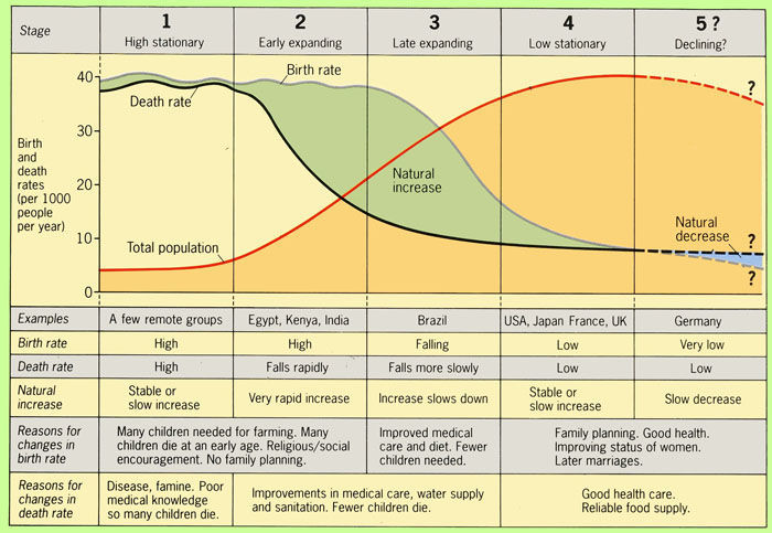
Caption: : demographic transition model
the demographic transition model
Slide 8
population pyramids
population pyramid; shows the population by categorising them into categories (for example age)
concave - dipping inwards.- shows a rapid, increasing population growth convex - dipping outwards- shows a decreasing population growththe bottom of the pyramid is called a basethe top of the pyramid is called the apex
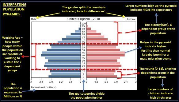
Caption: : population pyramid; age
Slide 9
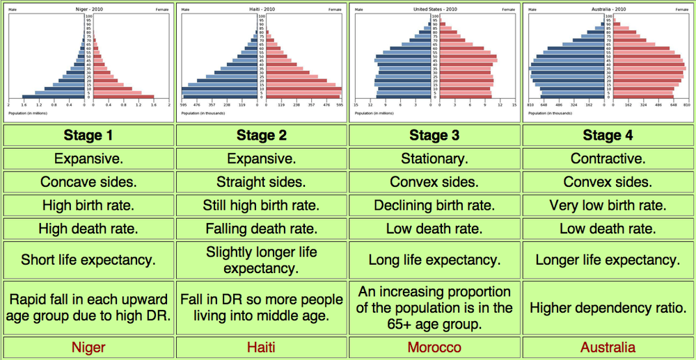
stages 1 and 2 of population pyramids
stage 1. birth rates are very high as people have children to help them work the land as well as look after their parents when they turn old. No contraception is used. Death rate is very high because of high level of diseases and no medical treatment, this means young children die. TRADITIONAL TRIBESstage 2. birth rate remains high because it is traditional to have large families. Death rate begins to drop because go improvements in the health care system and vaccines. also there is a improvement in quality and quantity of food and water supply. AFGHANISTAN
Caption: : diffrent stages of population pyramids
Slide 10
stage 3. birth rates now level off at a low level as education and birth control programs become more available, and tradition of large families are lost. children becomes an economic burden. BRAZILstage 4. birth now begins to fall because people are beginning to become more educated, birth control programs, more children survives. Death rate continues to fall then levels off as improvements in health care improve as well as water supply. GERMANY
stage 3 and 4 of population pyramids
Caption: : diffrent stages of population pyramids
Slide 11
population explotion
why has the population grown?
the farmers started to produce more food which could feed more people
better child survival because there has been an improvement in the health care system
there are more women in the world today, which can produce more children
what problems can overpopulation cause?
traffic, the more people there is the move vehicles there are on the streets
pollution as there as more people the amount of pollution increases as there is a higher demand for fuel
high crime rate
not enough health care and education for everyone
lack of employment
lack of housing
food scarcity
solution?educate people about birth control and contraception
Slide 12
under population
why do people choose to have less children?
children are seen as an economic burden
people are more educated on birth control
government restriction (chinas one child policy)
people concentration on careers
later marriages
what problems can this cause
shortage of workers
difficult to defend the country
economic decline
need to raise taxed
ageing population
solutionoffer incentives based on the amount of children people have (tax reduction, reduction in school fee)
Slide 13
population growth in different rates
why do population grow in different rates?
education and availability about contreception
quality of health care
children - economic asset or burden
availability of resources
develop or developing country
migration rate
issues within the country (war, disease)
population policies
5 top country affected by HIV
Botswana
Lesotho
South Africa
Zimbabwe
HIV has affected the population. If you look at the population pyramid you can see the infant mortality rate has fallen for ex. Botswana, because the unavailability of medical care children are dying at a younger age.
Slide 14
ageing population
causes;
better diets
improvement in health care
population vaccines against deadly diseases
effects;
bigger burden on the economically active population
people have to work more
charges may be made for health care
Slide 15
1.2 Migration
Explain and give reasons for population
migration
Demonstrate an understanding of the
impacts of migrationInternal movements such as rural-urban
migration, as well as international migrations,
both voluntary and involuntaryPositive and negative impacts should be
considered, on the destination and origin of the
migrants, and the migrants themselves international migration - Mexico to USA
Slide 16
Key terms
migration; the movement of people
emigrants; people leaving their country
immigrants; people who are migrating into a country
migration balance; people migrating in - people migrate out
temporary migration
seasonal migration
voluntary migration
daily migration
force migration
push factors
pull factors
Interventing obstacles
Slide 17
1.3 Population Structure
Identify and give reasons for and implications
of different types of population structureAge/sex pyramids of countries at different
levels of economic developmenta country with high dependent population - Japan or UK
Slide 18
1.4 population density and distribution
Describe the factors influencing the density and distribution of populationPhysical, economic, social and political factors
country with a low population density - NW and NE Brazil
country with a high population density - SE Brazil
Slide 19
Key terms
population density
sparsely populated
densely populated
even distribution
uneven distribution
Slide 20
case study on Brazil and how the goment made it hard to access to the amzone, and roads
Slide 21
1.5 settlement and service provision
Explain the patterns of settlement
Describe and explain the factors which may
influence the sites, growth and functions of
settlementsGive reasons for the hierarchy of settlements
and servicesDispersed, linear, and nucleated settlement
patternsInfluence of physical factors (including relief,
soil, water supply) and other factors (including
accessibility, resources)
High-, middle- and low-order settlements and
services. Sphere of influence and threshold
populationsettlement and service provision in an are - London or SE England
Slide 22
1.6 Urban settlement
Describe and give reasons for the
characteristics of, and changes in, land use in
urban areasExplain the problems of urban areas, their
causes and possible solutionsLand use zones including the Central Business
District (CBD), residential areas, industrial
areas and the rural-urban fringe of urban areas
in countries at different levels of economic
development The effect of change in land use and rapid
urban growth in an urban area including the
effects of urban sprawl
Different types of pollution (air, noise, water,
visual), inequality, housing issues, traffic
congestion and conflicts over land use changeAn urban area - LONDON’S ZONES, (POLLUTION AND MANAGEMENT METHODS
Slide 23
1.7 Urbanisationn
Identify and suggest reasons for rapid urban
growth
Describe the impacts of urban growth on both
rural and urban areas, along with possible
solutions to reduce the negative impactsReference should be made to physical,
economic and social factors which result
in rural depopulation and the movement of
people to major cities
The effects of urbanisation on the people and
natural environment. The characteristics of
squatter settlements
Strategies to reduce the negative impacts of
urbanisation
Slide 24
The Natural Environment
2.1 earthquakes and volcanoes 2.2 rivers2.3 coast2.4 weather2.5 climate and the natural vegetation
Slide 25
Key terms
densitycompositionphysical stateasthenospherecrustmantleouter corethe corebasalttrenches continental crustoceanic crusttectonic plates plate boundariesconstructive plate boundariesdestructive plate boundaries conservative plate boundaries
Slide 26
earthquakes and volcanoes 2.1
Describe the main types and features of
volcanoes and earthquakesDescribe and explain the distribution of
earthquakes and volcanoes
Describe the causes of earthquakes and
volcanic eruptions and their effects on people
and the environment
Demonstrate an understanding that volcanoes
present hazards and offer opportunities for
people
Explain what can be done to reduce the
impacts of earthquakes and volcanoesTypes of volcanoes (including strato-volcanoes
[composite cone] and shield volcano)
Features of volcanoes (including crater, vent,
magma chamber)
Features of earthquakes (including epicentre,
focus, intensity)
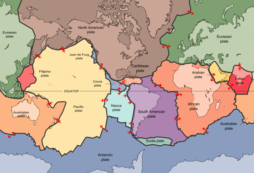
The global pattern of plates, their structure,
and an awareness of plate movements and their effects – constructive/divergent,
destructive/convergent and conservative plate
boundaries
earthquake - Haiti (2010) or Japan (2011)
volcano - Mt. St. Helen
Slide 27
structure of the earth
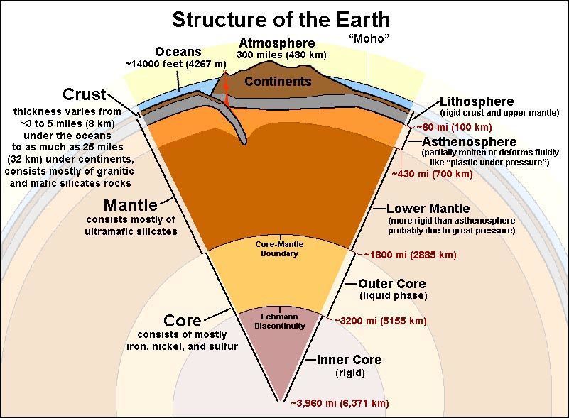
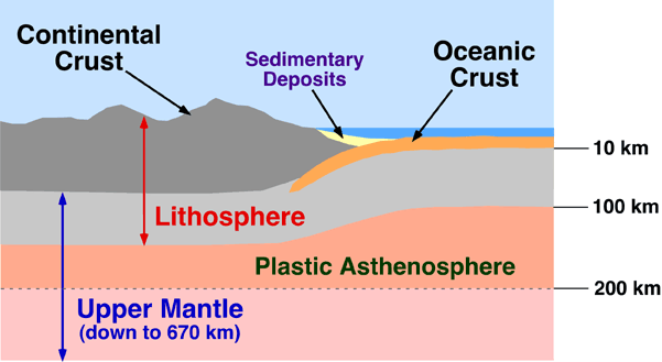
Caption: :
Slide 28
continental and oceanic crust
continental crust
mainly made out of granite
thicker than basalt
30 - 50 km thick
it's thicker but less dense
the continental crust is mainly made out of granite, its thicker than basalt however it is less dense compared to basalt. This is because when molten rock cools down and solidifies the process is slower. As the molten rock cools, the larger the crystals become. For example, gabbro has larger crystals than basalt because the molten rock that formed gabbro cooled more slowly. The continental crust is 30 - 50 km thick.
oceanic crust
mainly made out of basalt
thiner than granite
6 - 8 km thick
it's thiner but denser
the oceanic crust is mainly made out of basalt, and it's denser than the continental crust because it cools quicker creating smaller crystals due to its location under the sea or ocean. The oceanic crust is 6 - 8 km thick..
Slide 29
plate tectonics
An earthquake is caused by sudden shifting of the platesA volcano forms when liquid rocks burst out through earths surface
Slide 30
destructive (convergent)
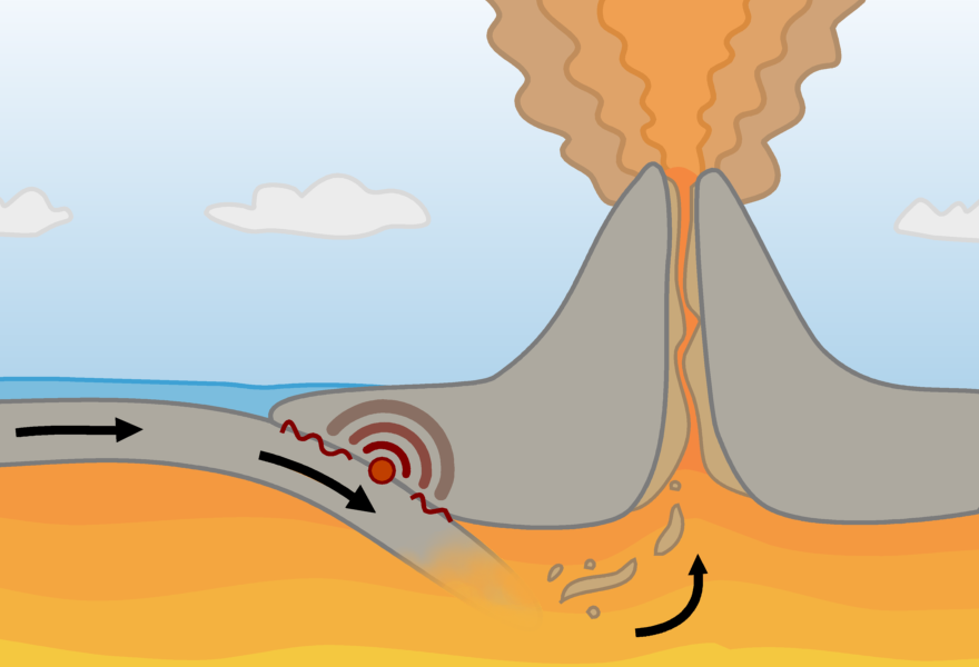
Caption: : example ; Nazca and the South American plate
As the plates move toward each other the oceanic plate is destroyed because it is denser, forcing it beneath the less dense continental plate at a 45* angle. An ocean trench is created because the oceanic plate is dragged down. Friction between the two plates causes an earthquake, a volcano and more mountains to form. An example would be the Nazca and the South American plate.
Slide 31
constructive (divergent)
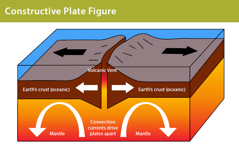
Caption: : example ; Iceland
As two plates move away from each other molten rocks / magma rises to fill any possible gaps. As it dries up, it creates gabbro. Because the ocean is widening 2-3 cm per year it causes earthquakes and gentle volcanoes to form. This happens because convection current pushes them away from each other creating mid ocean ridges with volcanoes. An example would be Iceland.
Slide 32
collision
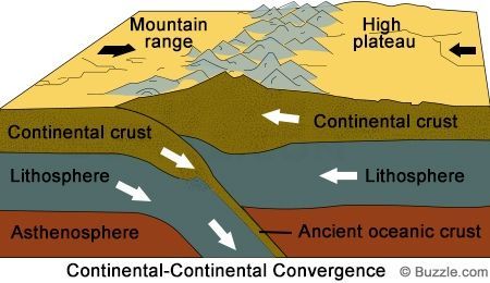
Caption: : example; Mt. Everest (Himalayas) in India and Eurasian plate
Here the continental crust can not sink or be destroyed. The collision of the two plates causes the inverting sediment (layers of material) to push upwards creating mountains. The continental plate is moving 25 mm per year. The hottest part of our earth is the core and it heats uptake magma above it, that pushes and drags the tectonic plates towards each other. An example would be the Himalayas.
Slide 33
conservative / transform / passive
As two plates slide past each other no plates are being destroyed, dragged towards each other or pushed down, thus no volcanoes or mountain are being formed. However an earthquake may appear if there is friction between the two plates. Thus shock waves are shot up causing an earthquake. An example would be The San Andreas Fault in California - the North American and Pacific plate.
Caption: : The San Andreas Fault in California
Slide 34
Volcanoes
Slide 35
convection currents
The core is around 5500* C to 6000* C due to radioactive decay, this causes the magma to become less dense thus causes the magma rises towards the crust. This is because the particles are heated and begin to move apart. As the magma rises it hits the earths crust pulling it apart or colliding it towards each other (destructive / constructive plates). The then cools down becoming more dense and sinks down towards the core again.
Slide 36
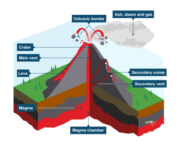
volcanoes
strato volcanosteepness of side6 - 10* slopes at the bottom and 30* near the summit. The steep slopes result from short, wide and vicious eruptions. (Because rock and ash build up in thick layers around the volcano)eruption materialalternating layers of lava and pyroclastic material, because that is usually the material that comes out when its a more explosive and violent.type of boundarydestructive plate boundaries. The oceanic crust melts and rises up through the continental crust to erupt. they have massive violent and very loud explosions of rock and ash because they erupt very rarely and thus have a lot of trapped gases so huge pressure builds up from beneth
shield volcanosteepness of sideit's a more gentle slope at 5* angle, and a steeper lower slope with a 10* angle. They usually have a rough circular or oval wide shape area.. Because the runny lava spreads out a long way from the point of eruption.eruption materialrunny lava, because the low viscosity allows the lava to flow quicklytype of boundaryconstructive plate boundaries. Because a gap is left and lava from the mantle rises up to create new land.they have more gentle eruptions with runny lava because they erupt more frequently and have no gases in them so no pressure builds up
Slide 37
why do people live near volcanoes
fertile soil - the break down of volcanic rock produces soil rich in nutrients. This means that crops grow well and support large numbers of people to produce more than they need so that they can sell some. Example the Philippines around 30 000 people live around Mt. Pinatubo.geothermal energy - countries such as New Zealand and Iceland that have volcanic activity close to the surface use the heat from the volcanoes to produce about 70% of their energy needs by pumping water into the ground and releasing it as steam to drive turbines.tourism - many people are fascinated by volcanoes and like to visit them. This brings money into the area and encourage businesses such as hotels and shops and tour guides to set up in the area. An example would be Mt. St Helens minerals - when lava in a volcano cools it often leaves the area rich in minerals deposits such as gold, silver, copper and diamonds. This means that people can extract these by mining and make a living
Slide 38
management
lava divergent channels (tunnels leaving lava away)
early prediction - seismometer, detects earthquakes by measuring the angle of bulge
Slide 39
earthquakes
impacts;
infrastructure damage
death
downfall of economy
tsunami
liquefaction
landslide
liquefaction is when water surfaces due to vibration of land
Slide 40
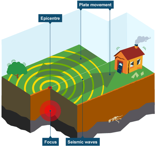
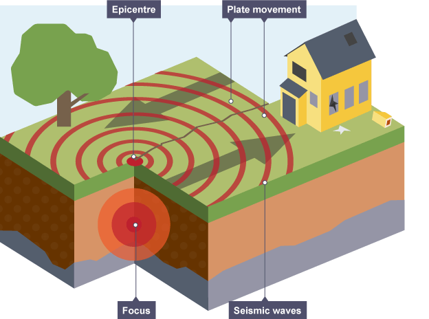
powerful forces pushes two huge mass of rock into each other. The rock stores up pressure as strain energy
but suddenly the pressure becomes too much. One mass of rock gives away and will move upwards. The stored energy is released in waves.
the shaking of the ground is called an earthquake
as the rock settle into its new position there will be lots of smaller earthquakes called aftershocks
focus; of the earthquake is the point where the waves startepicentre; is the point directly above it on the earths surface.
Earthquake
Slide 41
case study
Japan
the earthquake lasted 5 minutes
magnitude of 9
the Eurasian plate and the Pacific plate pushed against each other
impacts
the coast sank 1m
waves then traveled 60km per sec
here the waves are fast but not damaging yet
however they slow down to 3km per second and become damaging
Fucusima - destroyed power reactor
the tsunami was 6km deep and over 800km per hour
response
warnings were send to people via phone
the reactor was shut down however it was still in cooling process
quickly set up shelters
cleared the dead body washed ashore as it became unhygienic
Slide 42
river 2.2
Explain the main hydrological characteristics
and processes which operate within rivers and
drainage basins
Demonstrate an understanding of the work of
a river in eroding, transporting and depositing
Describe and explain the formation of the
landforms associated with these processes
Demonstrate an understanding that rivers
present hazards and offer opportunities for
people
Explain what can be done to manage the
impacts of river floodingCharacteristics of rivers (including width,
depth, speed of flow) and drainage basins
(including watershed, tributary, confluence)
Processes which operate in a drainage basin
(including interception, infiltration, throughflow,
groundwater flow, evaporation, overland flow)
Forms of river valleys – long profile and
shape in cross section, waterfalls, potholes,
meanders, oxbow lakes, deltas, levées and
flood plains
Causes of hazards including flooding and river
erosion
Opportunities of living on a flood plain, a delta
or near a river The opportunities presented by a river or rivers, the associated hazards and their management BANGLADESH, DELTA, FLOODING IN BANGLADESH, THREE GORGES DAM/KISSIMMEE RIVER RESTORATION
Slide 43
coast 2.3
Demonstrate an understanding of the work of
the sea and wind in eroding, transporting and
depositing
Describe and explain the formation of the
landforms associated with these processes
Describe coral reefs and mangrove swamps
and the conditions required for their
development
Demonstrate an understanding that coasts
present hazards and offer opportunities for
people
Explain what can be done to
manage the impacts of coastal
erosionCliffs, wave-cut platforms, caves, arches,
stacks, bay and headland coastlines, beaches,
spits, and coastal sand dunes
Hazards including coastal erosion and tropical
storms Cliffs, wave-cut platforms, caves, arches,
stacks, bay and headland coastlines, beaches,
spits, and coastal sand dunes
Hazards including coastal erosion and tropical
storms
Slide 44
weather 2.4
Describe how weather data is collected
Make calculations using information from
weather instruments
Use and interpret graphs and other diagrams
showing weather and climate data
Describe and explain the characteristics, siting
and use made of a Stevenson screen
Rain gauge, maximum-minimum thermometer,
wet-and-dry bulb thermometer (hygrometer),
sunshine recorder, barometer, anemometer
and wind vane, along with simple digital
instruments which can be used for weather
observations; observations of types and
amounts of cloud
Slide 45
climate and natural vegetation 2.5
Describe and explain the characteristics of two
climates:
• equatorial
• hot desert
Describe and explain the characteristics of
tropical rainforest and hot desert ecosystems
Describe the causes and effects of
deforestation of tropical rainforestClimate characteristics (including temperature
[mean temperature of the hottest month,
mean temperature of the coolest month,
annual range]; and precipitation [the amount
and seasonal distribution])
Factors influencing the characteristics of these
climates (including latitude, pressure systems,
winds, distance from the sea, altitude and
ocean currents)
Climatic graphs showing the main
characteristics of temperature and rainfall of
the two climates
The relationship in each ecosystem of natural
vegetation, soil, wildlife and climate
Effects on the natural environment (both locally
and globally) along with effects on people
an area of tropical rainforest - Borneo
tropical desert - Great Sandy Desert Australia
Slide 46
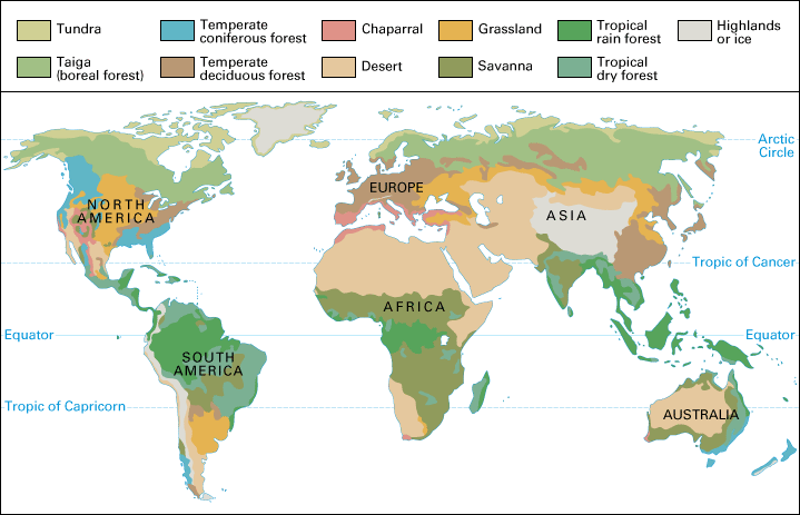
locations: tropical rainforest and deserts
Slide 47
Economic development
3.1 development3.2 food production3.3 industry3.4 tourism3.5 energy3.6 water3.7 environmental risk and development
Slide 48
development 3.1
Use a variety of indicators to assess the level
of development of a country
Identify and explain inequalities between and
within countries
Classify production into different sectors and
give illustrations of each
Describe and explain how the proportions
employed in each sector vary according to the
level of development
Describe and explain the process of
globalisation, and consider its impactsIndicators of development (including GNP per
capita, literacy, life expectancy and composite
indices, e.g. Human Development Index (HDI)
Primary, secondary, tertiary and quaternary
sectors
Use of indicators of development and
employment structure to compare countries at
different levels of economic development and
over time
The role of technology and transnational
corporations in globalisation along with
economic factors which give rise to
globalisation
Impacts at a local, national and global scale a transitional cooperation and its global links - NIKE
Slide 49
food production 3.2
Describe and explain the main features of an
agricultural system: inputs, processes and
outputs
Recognise the causes and effects of food
shortages and describe possible solutions to
this problemFarming types: commercial and subsistence;
arable, pastoral and mixed; intensive and
extensive
The influence of natural and human inputs on
agricultural land use. Inputs including natural
inputs (relief, climate and soil) and human
inputs (economic and social). Their combined
influences on the scale of production, methods
of organisation and the products of agricultural
systems
Natural problems which cause food shortages
(including drought, floods, tropical storms,
pests) along with economic and political
factors (including low capital investment, poor
distribution/transport difficulties, wars)
The negative effects of food shortages,
but also the effects of food shortages in
encouraging food aid and measures to increase
output
a farm agriculture system - rice paddies (banjar tangtu)
comercial farming - Swaziland
Slide 50
industry 3.3
Demonstrate an understanding of an industrial
system: inputs, processes and outputs
(products and waste)
Describe and explain the factors influencing
the distribution and location of factories and
industrial zonesIndustry types: manufacturing, processing,
assembly and high technology industry
The influence of factors including land, labour,
raw materials and fuel and power, transport,
markets and political factors
Their combined influences on the location,
scale of production, methods of organisation
and the products of the system
Industrial zones and/or factories with respect
to locational and siting factors industrial zone - high tech industry Bangladore, India
Slide 51
tourism 3.4
Describe and explain the growth of tourism in
relation to the main attractions of the physical
and human landscape
Evaluate the benefits and disadvantages of
tourism to receiving areas
Demonstrate an understanding that careful
management of tourism is required in order for
it to be sustainablean area of high tourism - Bali, Indonesia
Slide 52
energy 3.5
Describe the importance of non-renewable
fossil fuels, renewable energy supplies,
nuclear power and fuelwood; globally and
in different countries at different levels of
development
Evaluate the benefits and disadvantages of
nuclear power and renewable energy sourcesNon-renewable fossil fuels including coal, oil
and natural gas.Renewable energy supplies
including geothermal, wind, HEP, wave and
tidal power, solar power and biofuels energy supply in a country - China
Slide 53
water 3.6
Describe methods of water supply and the
proportions of water used for agriculture,
domestic and industrial purposes in countries
at different levels of economic development
Explain why there are water shortages in
some areas and demonstrate that careful
management is required to ensure future
suppliesMethods of water supply (including reservoirs/
dams, wells and bore holes, desalination)
The impact of lack of access to clean water
on local people and the potential for economic
development water supply in a country and management method - SW USA and The Colorado River
Slide 54
environmental risk and development 3.7
Describe how economic activities may pose
threats to the natural environment, locally and
globally
Demonstrate the need for sustainable
development and management
Understand the importance of resource
conservationThreats to the natural environment including
soil erosion, desertification, enhanced global
warming and pollution (water, air, noise, visual) an area where economic development is taking place causing the environment at risk - Linfen, China
Slide 55
Want to create your own Slides for free with GoConqr? Learn more.