
Karteikarten
Geography 9.4 ( Contemporary urban environments)
Karten in diesem Stapel (26)
- 1What is AlbedoReflectivity of a surface
-- It is a ratio between the amount of incoming isolation and the amount of energy reflected back into the atmosphere.
--Light surfaces reflect more than dark surfaces and so have a greater albedo - 2What is a microclimate?Small-scale variations in temp, precipitation, humidity, wind speed and evaporation that occur in a particular environment (urban area).
- 3What is Particulate air pollution?A form of air pollution caused by the release of particles and noxious gases into the atmosphere.
Emissions of particles can occur naturally but largely caused by combustion of fossil fuels. - 4What is Photochemical pollution?A form of air pollution that occurs mainly in cities and can be dangerous to health.
Exhaust fumes become trapped by temperature inversion and, in the presence of sunlight, low levels of ozone.
Associated with high-pressure weather systems - 5What are Temperature inversions?An atmospheric condition in which temperature, usually, increases with height.
As inversions are extremely stable conditions and do not allow convection, they trap pollution in the lower layers of the atmosphere. - 6What is the Urban Heat Island?The zone around and above an urban area, which has higher temperatures than the surrounding rural areas.
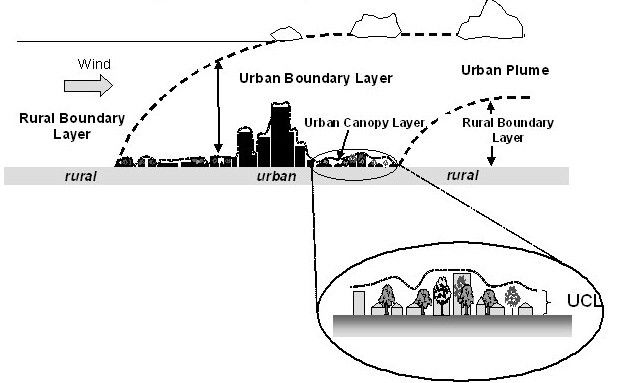
- 7What are the two layers in the urban dome?Urban Canopy - processes act in the space between buildings.
(above) Urban boundary layer - 8How does each element of climate vary in an urban area... -Temp -Precipitation -Relative Humidity -Wind Speed -Radiation -PollutionTemp - 0.5-0.8 degrees increase
Precipitation - 5-10% increase
Humidity - 6% decrease
Wind Speed - 20-30%
Radiation- 15-20% lower
Pollution (dust particles) - 1,000% increase - 9AS Urban and Suburban environment have higher temperatures than surrounding rural areas... WHat is the name given to this?Urban Heat Island (UHI)
- 10Why is the range of temperature from rural to CBD greatest at night?HIgh heat storage capacity of building materials compared to vegetation.
- 11Why is there little variation of temp over a body of water?Water maintains a high constant temperature over a 24-hour period due to its high heat capacity.
- 12Why do cities tend to be warmer than rural areas? (4 points)+ -Surfaces in cities are less reflective, building materials have lower albedo and act like bare rock surfaces, absorbing large amounts of heat
-Heat stored is slowly released at night
-Large windows in multi-storey buildings reflect heat downwards
+Air Pollution from industries and vehicles increases cloud cover and create a 'pollution dome'
-The 'dome' allows short-wave radiation but absorbs a large amount of the outgoing radiation as well as reflecting it back to the surface.
+Water falling onto the surface is disposed of as quickly as possible
-Changes the urban moisture and heat budget - reduced evapotranspiration means more energy is available to heat the atmosphere.
+Heat comes from industries, buildings and vehicles which all combust fuels
-Although regulating heat indoors, air conditioning units release heat into the atmosphere - 13WHy is the UHI a concern?+Rising temperatures make it very uncomfortable.
-Extreme UHI - increased heat stroke, organ damage, asthma
-Elderly and babies mostly affected
+Hot and still anticyclonic weather conditions responsible for UHI produce higher levels of pollution
-Because the chemical reactions which produce ozone and smog are accelerated in higher temp, with no winds keep the pollution in the city
+Excessive heat puts an increasing strain on the supply of energy for cooling and air conditioning
+Waarmer periods, increase consumption of water by residents and businesses
-Strain on water supply and can lead to restrictions
+4 MORE POINTS FOUND ON PG 408 - 14Q ABOUT STRATEGIES TO REDUCE THE UHIPG408
- 15Why is there a high precipitation over urban areas?+UHI generates convection. As round surfaces are heated, rapid evapotranspiration takes place
-Can result in Cumulus cloud and convectional weather patterns
+Precence of high rise buildings and mixture of building heights induces air turbulence and promotes increase vertical motion
+ Low pressure caused by rising air, surface winds drawn in from rural areas
-Air forces to rise over urban canopy
-FINISH PG410
+Pollution can cause an increase cloud formation and rainfall.
-Pollutants act as hygroscopic ( water attracting) nuclei, assisting in raindrop formation.
-Some believe that the pollutants enhance the change of lightning.
+Industries and power stations produce large amounts of water vapour - 16ADD ABOUT FOG, THUNDERSTORMS, WINDPG 410-412
- 17What is the cause an impact of Carbon monoxide?CAUSE - Road transport (produce 90%)
IMPACTS - Affect the transport of oxygen to cells in the body
-Breathing in low levels cause headaches, fatigue and nausea - 18What are the causes and impacts of Nitrogen oxides? -Reaction between hydrocarbons and nitrogen dioxide w/ sunlight present --OZONECAUSES -Road transport (50%)
IMPACTS - Inflame the lining of the lungs, increase impacts if suffers from Asthma
-Oxides of nitrogen cause weathering of buildings (Acid rain) - 19What are the cause and impacts of Particulate Matter?CAUSES - Originate mainly from power stations and vehicle exhausts
IMPACTS - Particulates smaller than 10 micrometres can settle in the lungs causing health problems - 20What are the causes and impacts of Sulphur dioxide? -Produced when a material or fuel containing sulphur is burntCAUSES - Coal and Oil burning by industries such as power stations
Impacts - Short-term cause coughing, tightening of the chest and narrowing of the airways
Also cause avid rain damage to lichen and plants - 21Why may pollution increase during the winter?Temperature inversions trap them over the city
- 22What is smog?Mixture of fog and smoke
- 23What is Photochemical smog?Photochemical oxidants - Ozone + peroxyacetyl nitrate
- 24What impacts does photochemical smog have?Headaches, eye irritation, coughs + chest pains
- 25What is the difference between low and high levels of Ozone?High- Protect us from UV radiation
Low- Action of nitrogen oxides and hydrocarbons gases causes a chemical reaction - 26FINISH - PG 414SOrry future Charlotte xoxo
Informationen
- Beschreibung
- Karteikarten am Geography 9.4 ( Contemporary urban environments), erstellt von Charlotte Willis am 07/01/2018.
- Erstellt von
- Charlotte Willis · Jan 2018
- Aktualisiert
- 6 Apr 2018
- Aufrufe
- 110
- Tags
- Bewertung