
Karteikarten
Tectonics
Karten in diesem Stapel (83)
- 1Define Seismic hazardsGenerated when rocks within 700 km of the earths surface comes under such stress they break and become displaced.
- 2Define Volcanic hazardAssociated with eruption events
- 3Describe the global distribution of volcanoes• Mostly on coasts
-Along the plate boundaries
• They are located between the pacific ocean and north and south america
• Many volcanoes are located in Iceland - 4What are the two types of crust?• Oceanic crust - younger, heavier, can sink and is constantly being destroyed.
• Continental crust - older, lighter, cannot sink and is permanent. - 5what are the 3 different types of plate movement due to convection currents?• Convergent plate boundary - where two plates are moving towards each other.
• Divergent plate boundary - when plate move away from each other
• Conservative/ Transform plate boundary - some plates move alongside each other - 6Define HotspotsAn area in the mantle which heat rises as a hot thermal plume – high heat and low
pressure causes the lithosphere to melt - rises through the cracks to the surface and erupts to form an active volcano. These volcanoes DO NOT occur on plate boundaries but are formed over a hot spot. - 7Formation of constructive divergent plate boundaries in oceans1) convection currents pull plates apart
2) as plates move apart, magma from the mantle-crust rises to fill the gaps and forms new oceanic crust
3) A mid-ocean ridge is formed by the new crust.
4) magma rises due to convection currents, leading to pressure and doming of the oceanic crust. eventually, magma erupts onto the surface. the continuous movement of the plates apart leads to more eruptions. - 8What are the 3 types of convergent(destructive) plate boundaries.• Oceanic - continental boundary
• Oceanic-oceanic boundaries
• Continental to continental boundary - 9Oceanic - continental boundary1) the movement of plates towards each other leads to the subduction of the denser oceanic plate
2) friction and pressure cause earthquakes to occur along the subduction zone
3) high temp and friction leads to the melting of the edge of the oceanic plat . less dense melt rises through mantle and pressurises the continental crust . cracking of continental crust due to collision creates path for magma. rising magma contains gas and is highly pressurised leading to explosive eruptions
4) A trench forms where the oceanic plate is being subducted
5) fold mountains form where the two plates collide. the force of the collision leads to upthrust of the plates forming mountains with folded geology. - 10oceanic-oceanic boundaries1) the movement of plates towards each other leads to the subduction of the denser oceanic plate
2) friction and pressure cause earthquakes to occur along the subduction zone
3) High temp and friction leads to the melting of the edge of the oceanic plate, magma escapes to the surface to form volcanoes, a few kilometres from the trench. after several eruption, these volcanoes break the oceans surface to form islands. When several volcanic islands form together they are called an island arc. No formations of fold mountains - 11continental to continental boundary1) When two continental plates meet at a destructive plate boundary, a slow collision takes place as both plates have a low density
2) This results in intense folding and uplift and leads to the formation of fold mountains.
3) There is no subduction so there are no volcanoes
4) However, earthquakes occur due to the collision of the plates. - 12Transform/conservative boundariesWhere the plates just slides past each other with crust neither created nor destroyed. E.g. the San Andrea fault in California marks the junction of the North American and pacific plates. Both plates are moving north-west but at different speeds. Instead of slipping smoothly past each other, they tend to 'stick'. The pressure builds up until suddenly the plates move forward and an earthquake occurs.
- 13What are Intraplate earthquakes?Intraplate earthquakes do not occur near plate boundaries, but along faults in the
normally stable interior of plates. These
earthquakes often occur at old
structures as they may present a weakness in the crust where it can easily slip to
tectonic strain. - 14What is continental drift?A concept which suggests that continents can move around the earth’s surface because of weakness of the sub oceanic crust.
- 15Define BasaltFine-grained, igneous rock, underlying more of the earth's surface than any
other rock type, especially ocean basins. Associated mainly with
constructive plate boundaries. - 16Define AndesiteTypically found in lava flows produced by stratovolcanoes. Generally
formed after an oceanic plate melts during its descent into the subduction
zone. - 17Define RhyoliteFormed from granitic magma in continental or continentmargin volcanic
eruptions where granitic magma reaches the surface. Rhyolite is rarely
produced at oceanic eruptions. - 18Define Benioff ZoneA dipping flat zone where earthquakes are produced by the interaction of a
downgoing oceanic crustal plate with a continental plate. - 19Define Subduction zoneThe place where two lithospheric plates come together, one riding over the
other. Most volcanoes on land occur parallel to and inland from the
boundary between the two plates. - 20Define Crustal fracturingOccurs when the earth’s crust causes rock to break and fracture under stress and strain caused by seismic stresses.
- 21Primary effectshappen immediately and occur as a direct result of the ground shaking like buildings
collapsing. - 22Ground shakingGround shaking is most direct effect with cracks in land and structures, falling masonry and / or collapse.
- 23Secondary effectsoccur as a result of the primary effects, for example, fires due to ruptured gas mains.
- 24Ground displacementmay not be life threatening; however, it impacts on buildings, bridges and roads.
- 25Landslidesare movements of masses of rock or debris down a slope. Slope failure can be triggered by, for example, earth tremors.
- 26Liquefactionoccurs when the shaking of silts, sands and gravels causes them to lose their load
bearing capacity. Buildings and other structures, may thus sink into the ground. - 27What causes Tsunami's?● A tsunami forms when energy from an earthquake vertically jolts the seabed by several metres, displacing water.
● Large waves begin moving through the ocean, away from the earthquake's epicentre.
● In deep water, the tsunami moves at great speeds. When it reaches shallow water near coastal areas, the tsunami slows but increases in height. - 28what are the two types of seismic body waves:● Primary-waves: faster and longitudinal, and can travel through solids and liquid, so they can travel through the earth’s core.
● Secondary-waves: slower and transverse, and can only travel through solids (NOT liquids). - 29What is refraction?● The speed of waves increases with depth, so waves travel in curved paths.
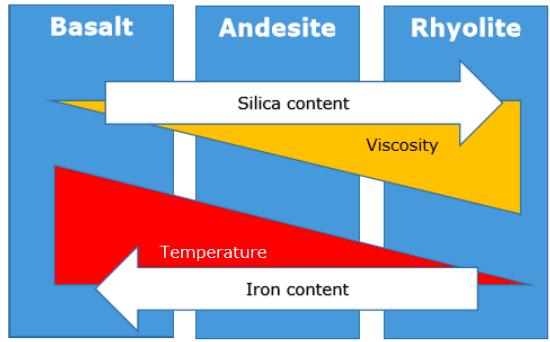
● If the type of material changes suddenly then the direction of the wave changes suddenly too. - 30what are the three magma types?● Basalt
● Andesite
● Rhyolite - 31Hazard VolcanoesAn eruption is caused by the pressure of dissolved gas building up in the magma. When it becomes greater than the surface can take, the volcano erupts.
- 32Composite Cone VolcanoesThe volcano is built up of alternate layers of LAVA and ASH. They can explode with great violence. The eruptions from these volcanoes may be a pyroclastic flow
rather than a lava flow. A pyroclastic flow is a mixture of hot steam, ash, rock and dust. E.g. Mt St Helens, USA - 33Shield (Basic) VolcanoesShield Volcanoes are enormous features built up only from layers of lava. They produce lots of lava but they tent not to erupt violently.These are usually found at constructive boundaries. They are low, with gently sloping sides. Shield volcanoes are formed by eruptions of thin, runny lava. Eruptions here tend to be frequent but relatively gentle. E.g. Mauna Loa Hawaii -USA
- 34Physical properties of magma
- 35Define Natural hazardsNaturally occurring physical
phenomena caused either by rapid or slow onset events - 36Define Natural disastersAny catastrophic event (great damage
or loss of life) that is caused by natural processes of the
earth - 37Crustal Deformation of earths surfaceThis deformation is the result of forces that are strong enough to move ocean sediments to an elevation many thousands of meters above sea level. This displacement of rock can be caused by tectonic plate movement and subduction, and volcanic activity.
- 38Deformation of rockinvolves changes in the shape and/or volume of these substances. Changes in shape and volume occur when stress and strain cause rock to buckle and fracture or crumple into folds.
- 39Define folda bend in rock that is the response to compressional forces. Folds are most visible in rocks that contain layering.
- 40what conditions must be met for plastic deformation of rock to occur?● The rock material must have the ability to deform under pressure and heat.
●The higher the temperature of the rock the more plastic it becomes.
●Pressure must not exceed the internal strength of the rock. If it does, fracturing occurs.
● Deformation must be applied slowly. - 41Define HazardA situation that poses a level of threat to life, health, property, or environment
- 42Define Resiliencethe capacity to recover quickly from
difficulties - 43Define Vulnerabilityinability to withstand the effects of a
hostile environment. - 44Disaster Risk EquationRisk = Hazard x Vulnerability / Capacity to cope
- 45Dregg's model
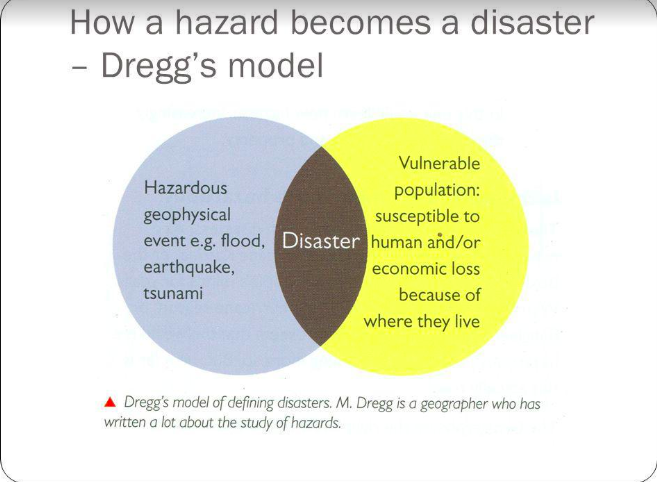
- 46When does a natural hazard become a disaster?Swiss Re defined a disaster as
● At least 20 people died
● Insured damage of over US$16 Million
EM-DAT international database suggests
● At least 10 people are killed
● More than 100 people are affected
● A state of emergency is declared and
international assistance is required. - 47Pressure and release model
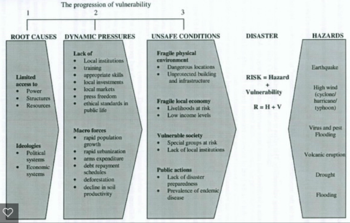
- 48Scales to measure earthquakes and volcanoes are known as:● Richter
● MMS
● VEI
● Mercalli - 49Richter ScaleThe Richter Scale is designed to allow easier comparison of earthquake magnitudes, regardless of the location.The Richter scale is derived from the measured displacement of the seismograph needle during an earthquake. Not accurate for very large earthquakes because the seismograph could be overwhelmed
with vibrations and the needle might not record all of them accurately as a result. - 50MercalliThe Mercalli scale rates the intensity of the earthquake vibrations felt at various places on earth. It has a subjective rating and can be useful for helping scientists learn where poor soil conditions may have resulted in stronger vibrations. But it requires gathering many eyewitness facts, and people feeling an earthquake are often not very accurate in their descriptions.
- 51Richter vs MercalliThe Mercalli scale measures the intensity of earthquakes and the Richter scale aims to measure the energy released during the earthquake.
- 52Moment Magnitude Scale (MMS)based on the total moment release of
the earthquake. The moment is a product of the distance a fault moved and the force required to move it. It works over a wider range of earthquake sizes and is applicable globally.
more accurate than Ritcher scale
more time consuming - 53Volcanic Explosivity Index (VEI)measure the relative explosiveness of
volcanic eruptions. It measures how much
volcanic material is ejected, the height of the material thrown into the atmosphere, and how long the eruptions last. - 54VEI - Issues●Density and gas bubbling of the volcanic
products in question are not taken into
account.
●Difficult to use VEI on prehistoric or
unobserved eruptions.
●The index is not as significant as sulphur dioxide emissions in quantifying volcanic atmospheric and climatic impact - 55Hazard profile● Categorises and simplifies the
risks associated with different hazards.
● Hazard profile includes : frequency, speed of onset, duration.
● Allows people to compare the physical processes and attributes that hazards share. It also allows decision makers and key players in terms of managing hazard - 56Define Mitigationthe effort to reduce the loss of life and property by lessening the impact of
disasters. - 57How do you manage hazards?● prediction
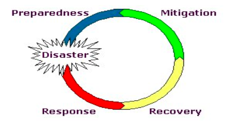
● preparation - 58Disaster Management Cycle
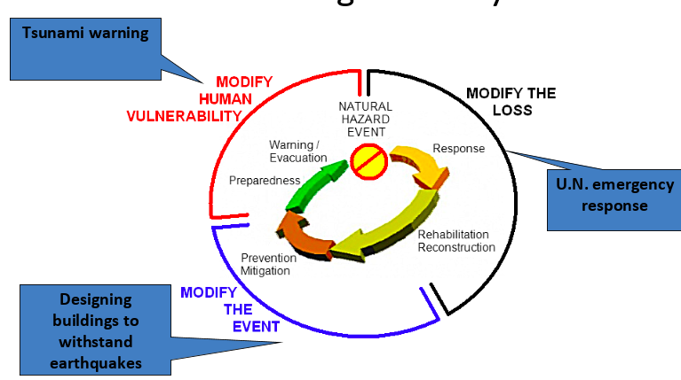
- 59Disaster Management Cycle key terms definition● Modifying the Loss: Minimising losses through aid and insurance
● Modifying the Event: Controlling the causes to prevent a hazard or developing hazard-resistant technology
● Modifying Human Vulnerability: Predicting events and improving education and community preparedness - 60The hazard management cycle
- 61How do countries send a warning for hazards?Mobile phones are increasingly used as
part of preparation activities and warning communication. An example of this is Japan's SMS alerts - Japanese agencies send SMS alerts to every registered mobile in the counrty as soon as p-waves are detected. - 62The Park Model
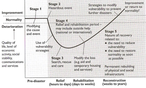
- 63Define The relief phaseThe immediate response, the focus is on saving lives and property. Urgent medical supplies, rescue equipment, clothing and food may be brought in.
- 64Define Rehabilitation phaseefforts are made to restore physical and community structures, at least temporarily.
- 65Define Reconstruction, mitigation and preparednessPermanent changes are introduced to restore the quality of life and economic stability to the pre-disaster level or better.
- 66Define Adaptation/ Modificationthe ability of a system to change its characteristics or behaviour so as to cope better with existing or anticipated external stresses
- 67what are the two types of mitigation?● primary mitigation the presence of the hazard, where possible, and of the vulnerability is reduced.
● Secondary mitigation is intended to decrease the impact of the hazard through preparedness and planning. - 68What is a disaster Hotspot?The WB has stated that a disaster hotspot is when two or more hazards occur in vulnerable places.
- 69What are the primary effects of a volcano:●Large rocks were thrown out during the eruption – bombs - crush and set fire to anything they hit.
● A super-hot avalanche of rock and ash – pyroclastic flow - engulfs everything in its path in dense ash.
● Ash and toxic gases, including sulphur dioxide, create an eruption cloud, which pollutes the atmosphere over a large area and can contribute to acid rain.
● Lava - molten rock - flows slowly, but is very destructive, burning anything in its path and cutting off escape routes.
● Mudflows can be swift, silent and lethal, engulfing homes many kilometres away from the volcano. - 70Causes of plates moving towards each other-Continents drift apart
-Ocean basins change in size & form
-Formation of major land forms such as mountains chains & mid-ocean ridges.
-Earthquakes, volcanic eruptions & tsunamis - 71How are earthquakes formed?Earthquakes are caused by sudden movements of the Earth's crust relatively close tot he surface, usually along a pre-existing fault. The movements is the result of a gradual-buildup of tectonic pressure and then its sudden release.
- 72what does the impact of a tsunami depend on?-duration of the event
-wave frequency & distance travelled
-depth & gradient of the offshore zone
-degree of coastal protection provided by mangrove & coral reefs
-quality of warning systems
-population density - 73Pyroclastic flowThe frothing of magma at the vent produces bubbles that burst explosively to eject hot & poisonous gases as well as hot fine materials. Clouds formed of these gases & materials are most lethal when they roll down the sides of a volcano.
- 74Teprha (ash falls)Rock fragments ejected into the atmosphere & ranging in size from "bombs" to fine dust.
The accumulation of teprha on roofs starts fires & causes buildings to collapse. - 75LaharsMudflows created by the combination of heavy rain on slopes covered by fine volcanic material.
- 76JokulhaupsCatastrophic floods caused by volcanic eruptions beneath glaciers.
- 77Hazard-risk formularisk=hazard x exposure x vulnerability / manageability
- 78Characteristics of hazard profiles-magnitude
-speed of onset
-duration
-areal of extent
-spatial predictability
-frequency - 79How does poor governance increases hazard vulnerability?-By failing to properly invest in infrastructure and that might mitigate the impacts of a tectonic hazard, eg failing to invest in warning systems, "hazard-proofing" buildings, etc.
-Being ill-prepared to deal with the emergency situation immediately following a hazard. - 80Modifying the hazard event ( actions)-strengthening coastal defences against tsunamis
-diverting or chilling lava flows
-increasing the stability of slopes where there is a high risk of landslides - 81Modifying vulnerability and resilience-improving prediction, forecasting & warning systems
-improving community preparedness:"hazard-proofing" buildings especially hospitals, police stations& pipelines that need to be fully operational immediately after the hazard event.
-changing behaviours that reduce the hazard: eg moving people away from high risk areas. - 82Sources of funding of disaster aid-donations by governments to intergovernmental organisations like the UN
-private donations to voluntary organisations & charities such as Red Cross, Oxfam & MSF - 83—
Informationen
- Beschreibung
- Geography Karteikarten am Tectonics, erstellt von Khushbu Chagane am 11/05/2018.
- Erstellt von
- Khushbu Chagane · Mai 2018
- Aktualisiert
- 20 Dez 2018
- Aufrufe
- 9
- Bewertung