4228614
Description
Flashcards by Kyle Summers (Mr, updated more than 1 year ago
|
|
Created by Kyle Summers (Mr
about 10 years ago
|
|
| Question | Answer |
| What do political maps show? | mainly cultural features |
| On political maps, state and country boundaries are usually shown by | colors and lines |
| Physical Maps show natural features such as oceans, rivers, and | mountains |
| Which of the following natural regions is found on the Great Plains? | grass |
| Lakes | are surrounded by land |
| Which of the following is true about plains? | Some are gently rolling |
| Which of the following landforms is the highest? Appalachian Mountains or Rocky Mountains | Rocky Mountains |
| Which half of the United States has the highest elevations? | west |
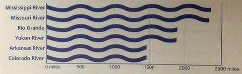
| Look at the graph below. About how long is the Rio Grande? | About 2,000 miles |
Want to create your own Flashcards for free with GoConqr? Learn more.