
Quiz
Geography: Landscapes of the UK quiz (Areas of the uk)
This quiz has question types that open in the usual player.
Questions in this quiz (24)
1Upland areas are [blank_start]unevenly[blank_end] distributed around the [blank_start]uk[blank_end]. The majority of the upland areas are located in the [blank_start]north[blank_end] of the uk in [blank_start]Scotland[blank_end], for example the largest area is the North [blank_start]West[blank_end] Highlands. However, the Cumbrian [blank_start]Mountains[blank_end] are located on the north west [blank_start]coast[blank_end] of England and one called [blank_start]Snowdonia[blank_end] in [blank_start]northern[blank_end] wales.
- Aunevenly
- BMountains
- Ccoast
- DSnowdonia
- Enorthern
- Fuk
- Gnorth
- HScotland
- IWest
2Sedimentary rock: [blank_start]Sedimentary[blank_end] rock forms from rock [blank_start]particles[blank_end] that are [blank_start]worn[blank_end] off other rocks (or the [blank_start]skeletons[blank_end] of sea creatures). The wearing away of these rock [blank_start]particles[blank_end] is called [blank_start]weathering[blank_end]. The rock particles are carried away by wind or [blank_start]water[blank_end] and eventually settle out and form layers called [blank_start]strata[blank_end]. As these layers build up the [blank_start]pressure[blank_end] from the layers above causes the layers below to become [blank_start]rock[blank_end]. Most sedimentary rocks are formed under [blank_start]water[blank_end].
- ASedimentary
- Bworn
- Cskeletons
- Dparticles
- Eparticles
- Fweathering
- Gwater
- Hstrata
- Ipressure
- Jrock
- Kwater
3Metamorphic Rocks: Metamorphic rocks are formed when [blank_start]sedimentary[blank_end] or [blank_start]igneous[blank_end] rocks undergo great [blank_start]heat[blank_end] and [blank_start]pressure[blank_end] below the [blank_start]Earths[blank_end] surface causing them to change. The type of [blank_start]metamorphic[blank_end] rock formed depends on the sedimentary or [blank_start]igneous[blank_end] rock that it was made from. Metamorphic rocks are rocks that have [blank_start]‘morphed’[blank_end] into other rocks. E.g. limestone becomes marble.
- Aigneous
- B‘morphed’
- Csedimentary
- Digneous
- Eheat
- Fpressure
- GEarths
- Hmetamorphic
4Igneous Rocks: [blank_start]Igneous[blank_end] rocks are formed from [blank_start]magma[blank_end] that has either cooled underground [blank_start](intrusive)[blank_end] or erupted at the earths surface from a volcano [blank_start](extrusive)[blank_end]. When magma [blank_start]cools[blank_end] at the surface it cools very quickly and forms tiny [blank_start]crystals[blank_end], too small to see with the naked eye. Magma that cools at the surface is called [blank_start]lava[blank_end]. When magma cools below the Earths surface it cools more [blank_start]slowly[blank_end] and forms [blank_start]large[blank_end] crystals.
- AIgneous
- Bmagma
- C(intrusive)
- D(extrusive)
- Ecools
- Fcrystals
- Glava
- Hslowly
- Ilarge
5Describe the characteristics of upland landscapes
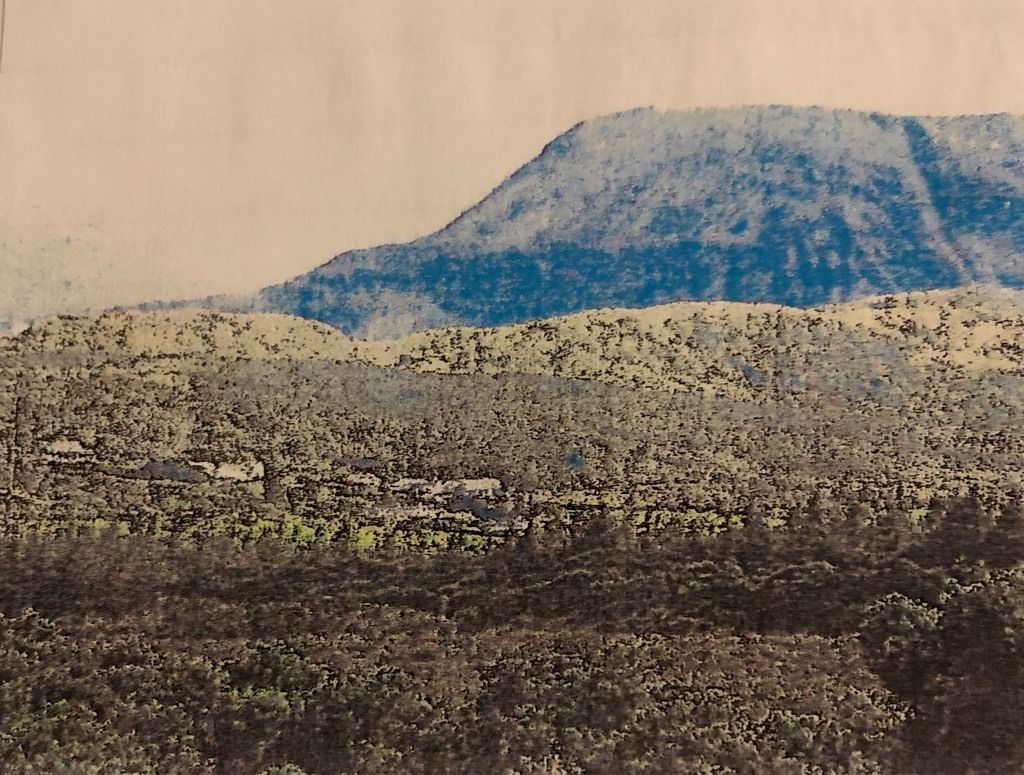
- Asteep hill
- Btimber plantation (little human presence)
- Cmore gentle sloping hills with grass
6Describe the characteristics of glaciated upland landscapes
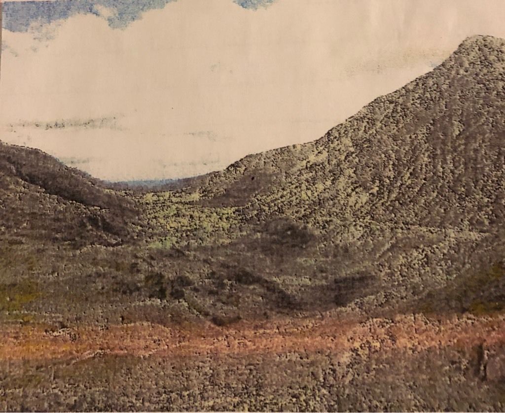
- Asteep mountainous rock
- Bu-shaped valley
- Csmall amounts of vegetation (grass,trees)
- Dno human presence
7Describe the characteristics of a lowland landscape
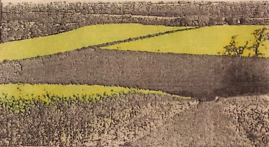
- AFlat land suitable for farming agr
- Bgentle slopes and flat plains
- Csparely populates, live in small villages
8Bodmin moor, [blank_start]Cornwall[blank_end]: it is a [blank_start]granite[blank_end] landscape made of [blank_start]igneous[blank_end] rock. After the [blank_start]tectonic[blank_end] uplift and [blank_start]erosion[blank_end] of overlying rock, the granite has now been [blank_start]exposed[blank_end]. One of the [blank_start]five[blank_end] upland areas of [blank_start]Dartmouth[blank_end]. Areas joined together underground by granite [blank_start]formation[blank_end]. [blank_start]Circular[blank_end] landscape that is [blank_start]25km[blank_end] in diameter. From [blank_start]Bodmin[blank_end] in the south-west to [blank_start]Launceston[blank_end] in the north-west. Area of [blank_start]400m[blank_end] of [blank_start]Moreland[blank_end] hills with [blank_start]steep[blank_end], often [blank_start]slopes[blank_end] [blank_start]hills[blank_end] and [blank_start]open[blank_end], often bleak [blank_start]rocky[blank_end] [blank_start]summits[blank_end]. Small outcrops of granite can be seen on many hilltops called [blank_start]tors[blank_end], the [blank_start]cheesewring[blank_end] is the most famous. The [blank_start]tor’s[blank_end] tend to have [blank_start]severed[blank_end] cracks or joints caused by pressure release as [blank_start]overlying[blank_end] rock is removed. [blank_start]Weathering[blank_end] enlarges the [blank_start]joints[blank_end] making them partially [blank_start]permeable[blank_end] and allowing some water to penetrate [blank_start]underground[blank_end]. The surrounding area made of [blank_start]sandstone[blank_end] erodes away faster then the [blank_start]granite[blank_end].
- ACornwall
- Bgranite
- Cigneous
- Dtectonic
- Eerosion
- Fexposed
- Gfive
- HDartmouth
- Iformation
- JCircular
- K25km
- LBodmin
- MLaunceston
- N400m
- OMoreland
- Psteep
- Qopen
- Rtors
- Stors
- Toverlying
- Urocky
- Vsloped
- Wsummits
- Xhills
- Ycheesewring
- Zsevered
- AAWeathering
- ABjoints
- ACpermeable
- ADunderground
- AEsandstone
- AFgranite
9Burton Fleming and [blank_start]Reighton[blank_end], Yorkshire Wolds: Located in [blank_start]North[blank_end] Yorkshire to the west of [blank_start]Scarborough[blank_end] and [blank_start]Bridlington[blank_end]. [blank_start]Lowland[blank_end] area of [blank_start]countryside[blank_end] underlaid by [blank_start]chalk[blank_end]. It is rich and well drained [blank_start]farmland[blank_end] where [blank_start]potatoes[blank_end] are grown. No large settlements but many smaller [blank_start]villages[blank_end] and hamlets. The villages are spaced apart fairly evenly.
- AReighton
- BNorth
- CScarborough
- DBridlington
- ELowland
- Fcountryside
- Gchalk
- Hfarmland
- Ipotatoes
- Jvillages
10The Nant Ffrancon valley, [blank_start]North[blank_end] Wales: It is a glacial [blank_start]trough[blank_end]/ [blank_start]u-shaped[blank_end] [blank_start]valley[blank_end]. The floor of the valley lies [blank_start]750m[blank_end] below the [blank_start]ridges[blank_end] one either side. Created by a [blank_start]glacier[blank_end] (moving ice). The [blank_start]glacier[blank_end] was was formed from a huge ice [blank_start]cap[blank_end] to the east called the [blank_start]Merioneth[blank_end] ice [blank_start]cap[blank_end], which had a thickness of [blank_start]650m[blank_end]. Over [blank_start]500,000[blank_end] years ago, several glaciers radiated out [blank_start]gouging[blank_end] the u-shaped valley as they moved downhill. The highest peaks remained above the ice but were severely affected by frost [blank_start]shattering[blank_end]. Other glacial periods have meant that smaller [blank_start]cirque[blank_end] glaciers have occupied the hollows on the hillside enlarging them to form [blank_start]corries[blank_end], which can be seen along the valley side. [blank_start]Llodkes[blank_end] such as Llyn Idwal are created when rainwater has collected since the last glacial period. The hills often have [blank_start]snow[blank_end] on the hilltops especially in the winter. Some river and roads run through the bottom of the valley. The areas is only habited by [blank_start]animals[blank_end], there are no villages or towns.
- ANorth
- Bvalley
- Ctrough
- Du-shaped
- E750m
- Fridges
- Gglacier
- Hglacier
- Icap
- JMerioneth
- Kcap
- L650m
- M500,000
- Ngouging
- Oshattering
- Pcirque
- Qcorries
- RLlodkes
- Ssnow
- Tanimals
11Spot heights: 1) Mark on [blank_start]points[blank_end] A and B. 2) Mark on each [blank_start]contour[blank_end] line between A and B writing the [blank_start]height[blank_end] in a sheet of paper 3) Create the x-axis of the graph by using the [blank_start]distance[blank_end] between A and B 4) Create the y-axis with [blank_start]units[blank_end] of [blank_start]height[blank_end] based on the [blank_start]contour[blank_end] heights of the image 5) Plot where the [blank_start]contours[blank_end] are on the graph using the sheet of paper 6) [blank_start]Connect[blank_end] each of the points to form the shape of the landscape
- Apoints
- Bcontour
- Cheight
- Ddistance
- Eunits
- Fheight
- Gcontour
- Hcontours
- IConnect
12What type of graph is this?
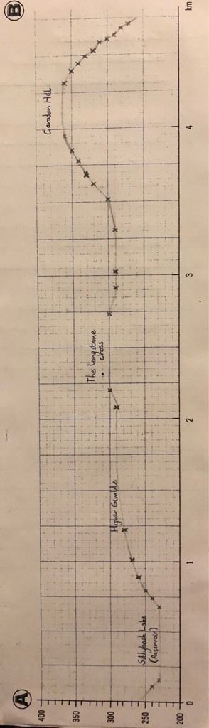
- Aspot heights
13Soils and the landscape: Soils are created from the [blank_start]weathering[blank_end] of rocks, [blank_start]organic[blank_end] material and [blank_start]water[blank_end]. The rocks in the area influences the [blank_start]vegetation[blank_end] and determine whether the land is suitable for [blank_start]farming[blank_end]. Areas of [blank_start]deep[blank_end] soil are often found in low lying areas and [blank_start]steep[blank_end] ground often has thin soil. Geology determines whether there is water [blank_start]draining[blank_end] over the surface, the [blank_start]density[blank_end] of streams and rivers, and the [blank_start]direction[blank_end] in which these flow over the ground. Water on the ground reduces [blank_start]peat[blank_end] soils, found in [blank_start]upland[blank_end] moors and heathland. [blank_start]Deep[blank_end] soils form beneath [blank_start]woodland[blank_end] because of organic [blank_start]material[blank_end] falling from trees over time. The natural vegetation would be [blank_start]deciduous[blank_end] woodland if humans left the earth alone. In [blank_start]1919[blank_end], the Forestry [blank_start]commission[blank_end] guaranteed future supplies after the depletion of [blank_start]woodlands[blank_end] during the WW1. This meant large parts of the uk were cloaked in woodland.
- Aweathering
- Borganic
- Cwater
- Dvegetation
- Efarming
- Fdeep
- Gsteep
- Hdraining
- Idensity
- Jdirection
- Kpeat
- Lupland
- MDeep
- Nwoodland
- Omaterial
- Pdeciduous
- Q1919
- Rcommission
- Swoodlands
14How climate affects landscapes: Climate is the [blank_start]long-term[blank_end] average of the temperature and rainfall experiences at a [blank_start]location[blank_end]. Climate has an obvious influence on the development of all landscapes because they are [blank_start]exposed[blank_end] to it, and may have been for [blank_start]millions[blank_end] of years. Rain, frost and wind are features of the climate of an area. The UK has a [blank_start]maritime[blank_end] climate, meaning it’s climate is heavily influenced by the [blank_start]seas[blank_end] that surround it. Onshore winds bring [blank_start]moist[blank_end] air, and the UK’s location means it is influenced by different [blank_start]air[blank_end] masses. Temperatures drop quickly with increased [blank_start]altitude[blank_end], which results in increased cloud over [blank_start]higher[blank_end] ground to the west. The [blank_start]prevailing[blank_end] (most common) wind direction also carries air up over the [blank_start]mountains[blank_end], and produces drier regions in the[blank_start] ‘rain shadow’[blank_end] to the east. The climate influences the rate at which [blank_start]geomorphic[blank_end] processes occur in these areas. [blank_start]Upland[blank_end] areas have much [blank_start]higher[blank_end] rainfall totals than [blank_start]lowland[blank_end] areas, and are also windier.
- Along-term
- Blocation
- Cexposed
- Dmillions
- Emaritime
- Fseas
- Gmoist
- Hair
- Ialtitude
- Jhigher
- Kprevailing
- Lmountains
- M‘rain shadow’
- Ngeomorphic
- OUpland
- Phigher
- Qlowland
15Describe how humans can affect an upland landscape: There are many ways that upland landscapes can be one example is [blank_start]logging[blank_end] which provides [blank_start]wood[blank_end], and with [blank_start]logging[blank_end] comes [blank_start]tree[blank_end] [blank_start]planting[blank_end] in order to [blank_start]sustain[blank_end] [blank_start]forests[blank_end]. Another way they are used is through [blank_start]wind[blank_end] [blank_start]farms[blank_end] which provide [blank_start]power[blank_end] through [blank_start]natural[blank_end] sources. Others include [blank_start]pastoral[blank_end] [blank_start]farming[blank_end] which is keeping [blank_start]livestock[blank_end] and [blank_start]reservoirs[blank_end] which provide water for [blank_start]urban[blank_end] areas.
- Alogging
- Bwood
- Clogging
- Dtree
- Eplanting
- Fsustain
- Gforests
- Hwind
- Ifarms
- Jpower
- Knatural
- Lpastoral
- Mfarming
- Nlivestock
- Oreservoirs
- Purban
16Describe how humans can affect a lowland landscape: One way humans affect [blank_start]lowland[blank_end] landscapes is through [blank_start]arable[blank_end] farming such as [blank_start]rapeseed[blank_end], wheat or [blank_start]barely[blank_end]. Also, [blank_start]solar[blank_end] farms can be built on these landscapes to create large amounts of [blank_start]electricity[blank_end]. Because they are [blank_start]flat[blank_end], the landscape can be [blank_start]urbanised[blank_end] with buildings such as towns and cities and [blank_start]infrastructure[blank_end] such as roads and street lighting. And finally, humans can build [blank_start]reservoirs[blank_end] for river water to flow into which can then be used as a water supply by [blank_start]urban[blank_end] areas. And finally, humans build [blank_start]infrastructure[blank_end] such as [blank_start]high[blank_end] rise [blank_start]development[blank_end], roads or railways.
- Alowland
- Barable
- Crapeseed
- Dbarely
- Esolar
- Felectricity
- Gflat
- Hurbanised
- Iinfrastructure
- Jreservoirs
- Kurban
- Linfrastructure
- Mhigh
- Ndevelopment
17Physical/ mechanical ([blank_start]freeze-thaw[blank_end]): In the [blank_start]day[blank_end], the [blank_start]rain[blank_end] fills cracks in the rock. Then alter at [blank_start]night[blank_end] the water [blank_start]freezes[blank_end] which makes the rock [blank_start]expand[blank_end] and this process continues until the crack [blank_start]widens[blank_end] and the rock eventually [blank_start]breaks[blank_end] into two.
- Afreeze-thaw
- Bbreaks
- Cday
- Dnight
- Erain
- Fexpand
- Gwidens
- Hfreezes
18Physical/ mechanical ([blank_start]exfoliation[blank_end]): Rocks have a lot of [blank_start]layers[blank_end], but only the outside layer is exposed to [blank_start]sunlight[blank_end]. When the [blank_start]sun[blank_end] [blank_start]shines[blank_end] onto the rock the outer layer [blank_start]expands[blank_end], when it’s [blank_start]cold[blank_end] (no sun) the outer layer [blank_start]contracts[blank_end] and over a long process of [blank_start]expanding[blank_end] and [blank_start]contracting[blank_end], the outer layer cracks and [blank_start]breaks[blank_end] away.
- Aexfoliation
- Blayers
- Csunlight
- Dexpands
- Ecold
- Fcontracts
- Gexpanding
- Hcontracting
- Ibreaks
- Jsun
- Kshines
19Biological: flora - A [blank_start]seed[blank_end] in the crack of the rock begins to grow and as the roots grow they [blank_start]break[blank_end] up the [blank_start]rock[blank_end]. Fauna ([blank_start]chillation[blank_end]) - The acids from animal [blank_start]waste[blank_end] erode the [blank_start]surfaces[blank_end] of the rock [blank_start]breaking[blank_end] it [blank_start]down.[blank_end]
- Aseed
- Bbreak
- Crock
- Dchillation
- Ewaste
- Fsurfaces
- Gbreaking
- Hdown.
20Chemical: [blank_start]rapid[blank_end] erosion - when we use factories to burn fossil fuels we make the rain [blank_start]acidic[blank_end] through the [blank_start]chemicals[blank_end] given off. The rain water then reacts with the rock to rapidly erode it. [blank_start]Slow[blank_end] erosion - rain water naturally constrains acid ([blank_start]CO2[blank_end]) but too much carbon means [blank_start]carbonic[blank_end] acid, the rain [blank_start]eroded[blank_end] the rock through [blank_start]eroding[blank_end] the minerals in the rocks. It breaks up the [blank_start]minerals[blank_end] and therefore the rock.
- Arapid
- Bcarbonic
- CSlow
- DCO2
- Eacidic
- Fchemicals
- Geroded
- Heroding
- Iminerals
21Mass movement ([blank_start]slumping[blank_end]/ [blank_start]rotational[blank_end] [blank_start]slip[blank_end]): when [blank_start]permeable[blank_end] rock (boulder clay) lies over impermeable rock ([blank_start]granite[blank_end]), the [blank_start]permeable[blank_end] rock can become [blank_start]saturated[blank_end] due to heavy [blank_start]rainfall[blank_end]. The rock then falls down the [blank_start]curved[blank_end] slope and turns as it falls.
- Aslumping
- Brotational
- Cslip
- Dpermeable
- Egranite
- Fpermeable
- Gcurved
- Hsaturated
- Irainfall
22Mass movement ([blank_start]rock fall[blank_end]): Due to a lot of [blank_start]weathering[blank_end], blocks of rock slide down the hill. [blank_start]Spontaneous[blank_end] sliding of many large rocks, caused by extreme [blank_start]freeze-thaw[blank_end] weathering.
- Arock fall
- Bweathering
- CSpontaneous
- Dfreeze-thaw
23Mass movement ([blank_start]mudflow[blank_end]): After long periods of [blank_start]heavy[blank_end] rainfall the soil on [blank_start]steep[blank_end] slopes becomes [blank_start]saturated[blank_end] so the mud and [blank_start]weak[blank_end] rock [blank_start]quickly[blank_end] flows down the slope.
- Amudflow
- Bheavy
- Csteep
- Dsaturated
- Eweak
- Fquickly
24Mass movement ([blank_start]landslide[blank_end]): [blank_start]cracked[blank_end] rocks/ rocks with [blank_start]joints[blank_end] that are [blank_start]aligned[blank_end] with the [blank_start]slope[blank_end] they are [blank_start]lying[blank_end] on them falls [blank_start]downwards[blank_end] in large groups. It is often started by [blank_start]freeze-thaw[blank_end] weathering.
- Alandslide
- Bcracked
- Cjoints
- Dslope
- Edownwards
- Ffreeze-thaw
- Glying
- Haligned
Information
- Description
- Quiz on Geography Landscapes of the UK quiz, created by Lauren Saberton on 06/02/2019.
- Author
- Lauren Saberton
- Language
- English
- Views
- 11
- Tags
- Rating
- No ratings yet Rate this quiz