
Fichas
AQA Geography A Coasts
Fichas del conjunto (64)
- 1What affects the formation of a wave?-Fetch
-Strength of the wind
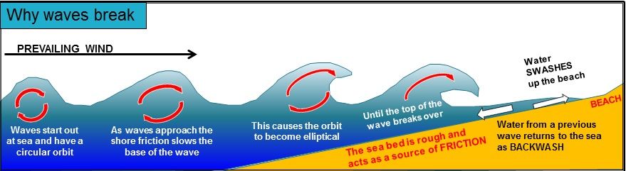
-Obstacles - 2Why do waves break?-Out at sea, waves have a circular orbit
-When they come into land, friction with the seabed makes the orbit elliptical
-The orbit becomes more elliptical due to increased friction until the top of the wave breaks - 3Diagram of waves breaking
- 4Characteristics of constructive waves-Weak backwash
-Strong swash
-Means that it deposits
-Formed by distant storms - 5Characteristics of destructive waves-Weak swash
-Strong backwash
-Means it erodes
-Closely spaced and interfere with each other resulting in chaos
-Crash down on the beach
-Formed by local storms - 6What are the 3 kinds of weathering?-Chemical (e.g. salt water against certain rocks)
-Biological (e.g. tree roots)
-Physical/Mechanical (freeze thaw) - 7What are the kinds of mass movement?-Rockfall
-Landslide
-Mudflow
-Rotational slip - 8What happens in Rockfall?fragments of rock break away from the face of the cliff, usually due to freeze thaw
- 9What happens in a Landslide?blocks of rock slide downhill
- 10What happens in a Mudflow?Saturated soil and weak rock flows down
- 11What happens in a Rotational Slip?slump of saturated soil and weak rock along a curved surface
- 12Types of erosion at the coast-Hydraulic power
-Corrasion
-Abrasion
-Solution
-Attrition - 13CorrasionFragments of rock being picked up and hurled at the cliff by the sea
- 14Hydraulic powerthe sheer force of the waves breaking bits off cliffs
- 15AbrasionThe sandpapering effect of pebbles grinding over a rocky platform
- 16Attritionfragments of rock caught by the sea knock against one another, causing them to be smaller and rounder
- 17SolutionSome rocks (e.g. limestone and chalk) are susceptible to being dissolved by saltwater
- 18Types of Transportation-Traction
-Saltation
-Suspension
-Solution
-Long shore drift - 19Tractionlarge pebbles rolled along the seabed
- 20Saltationhopping or bouncing motion along the sea bed of particles too heavy to be suspended
- 21Suspensionparticles carried by the water
- 22Solutiondissolved chemicals, often derived from chalk and limestone
- 23Longshore drift-Waves approach beach at the angle of the dominant wind (north west in northern hemisphere)
-Retreat at 90 due to gravity
-Causes zigzagging motion that carried sediment along the beach - 24Where does deposition occur?Deposition tends to occur in bays, where the energy of the wave is reduced
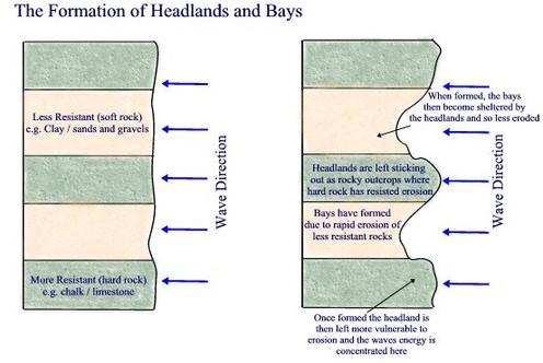
- 25Formation of headland and bays-Bands of resistant (hard) and less resistant (soft) rock
-Soft rock get's eroded away over time
-Leaves headlands of hard rock and bays of soft rock - 26Diagram for formation of headlands and bays
- 27Formation of a wave-cut notch-Waves break against a cliff
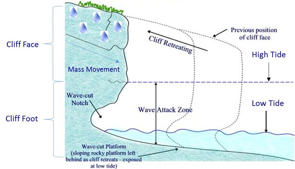
-Erosion (hydraulic action and corrasion) occurs near the high tide line
-Over time the notch gets deeper
-The cliff can no longer support itself, so collapses - 28Formation of a wave-cut platform-Continual wave-cut notches and cliff collapse the cliff line retreats
-This leaves behind a gently sloping rocky platform called a wave-cut platform
-Normally very smooth due to abrasion - 29Diagram of cliff collapse (including mass movement, wave-cut notches and wave-cut platforms)
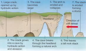
- 30Formation of a stump-Headland sticks out to sea with a lot of destructive wave
-Corrasion and hydraulic action erode a crack in the headland
-Crack get's eroded into a cave
-Eventually breaks through to the other side, leaving an arch
-Top of the arch collapses due to lack of support and gravity leaving a stack
-Stack is eroded down to a stump by weathering - 31Formation of a stump diagram
- 32Beaches-Beaches are a deposition of sand and shingle
-Sandy beaches are often found in sheltered bays
-Waves refract as they enter the bay and therefore lose their energy so deposition occurs - 33Formation of a spit-Spits occur when there is a break in the coast
-Longshore drift continues depositing however
-Eventually the spit breaks the surface forming new land
-If there is a wind opposing the prevailing wind it can form a hook at the end - 34Diagram of the formation of a spit
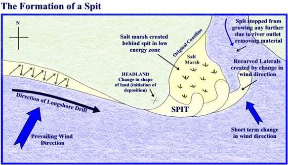
- 35Formation of a bar-Sometimes long shore drift continues and the spit grows across the bay, leaving a freshwater lagoon behind it
- 36Rising Sea Levels-Over the last 15 years seas have risen by 3 mm
-Predicted 28-43 cm by the end of the century
-Caused by thermal expansion of seawater - 37Rising Sea Levels Norfolk-Norfolk broads is a popular tourist destination
-Brings £5+ mill to the local area
-Rising sea levels would cause bad flooding - 38Rising Sea Levels Happisburgh-Rising sea levels will probably mean an increase in erosion
-Threatens settlements of cliffs like Happisburgh
-Coastal defences will be expensive - 39Rising Sea Levels East Anglia-Storm surge in 1953 that killed 300 people
-Such occurrences more likely with rising sea levels
-22% of East Anglian salt marshes could be gone by 2050 - 40Rising Sea Levels Thames Barrier-Protects buildings worth £80 bn
-needs replacement in the next 30 to 50 years
-As sea levels rise lower areas of Thames estuary at risk of flooding
-Affects housing and farmland - 41Barton-on-Sea Hampshire Location and Issue-Stretch of coastline in Christchurch bay
-Number of buildings lost due to cliff collapse
-Extensive coastal defences built, but new landslip in 2008
-Development of houses just 20 m from cliff edge
-Estimated that they will be lost in 10 to 20 years
-Rate of erosion up to 2 m - 42Barton-on-Sea Hampshire Natural causes-Rocks are weak sands and clays, easily eroded and little resistance to cliff collapse
-Permeable sand over impermeable clay causes water to pond up and increase the weight and pressure of the cliff
-Faces prevalent westerly winds with a long fetch
-Several small streams flow toward the cost but disappear in permeable sand - 43Barton-on-Sea Hampshire Human causes-Buildings of cliff top have made it heavier and more prone to collapse
- 44Shoreline management planan integrated coastal management plan for a stretch of coast
Details areas of high risk of erosion, flooding etc. and puts plans into place for how to cope with the issues - 45Sea Wall Description and cost-Concrete or rock barrier built at the foot of a cliff or the head of a beach
- 3-5 m high
-curved face to reflect waves
-Up to £10 million per km - 46Sea Wall Advantages and disadvantages-Effective
-Often has a walkway for people
-Can be obtrusive
-Very expensive
-High maintenance costs - 47Groynes Description and costTimber or rock structures built out to sea from the coast
-Trap sediment moving from longshore drift
-Wider beach offers more protection
-Up to £5 000 per m - 48Groynes Advantages and Disadvantages-Bigger beach for tourists
-Useful structures for fishing
-Not too expensive
-Starve beaches downdrift thereby increasing erosion there
-Unnatural and can be unattractive - 49Rock Armour Description and Cost-Piles of large boulders dumped at the foot of a cliff
-Force the waves to break and absorb their energy
-£1 000 - £4 000 per m - 50Rock Armour Advantages and disadvantages-Cheap and easy to maintain
-Often used for fishing
-Rocks from elsewhere in the country can be expensive to transport
-Can be obtrusive
-Don't fit with natural geology - 51Beach Nourishment Description and cost-Adding sand or shingle to a beach
-Sediment obtained locally so blends in
-£3 000 per m - 52Beach Nourishment Advantages and Disadvantages-Relatively cheap
-Easy to maintain
-Blends in
-Bigger beach means more tourists
-Needs constant maintenance unless structures are built to keep it in place - 53Dune Regeneration Description and cost-Sand dunes are easily destroyed
-So marram grass is planted to stabilise the dunes
-Areas are then fenced off to keep people off the newly planted dunes
-£20 per m - 54Dune Regeneration Advantages and disadvantages-Natural coastal environment for people and wildlife
-Relatively cheap
-Planting is time consuming
-Can be damaged by storms
-People don't like being fenced off - 55Marsh Creation Description and cost-Type of managed retreat
-Low-lying coastal areas are flooded to become salt marshes
-Salt marshes are effective barriers against the sea
-Cost depends on value of land
-£5 000 - £10 000 per ha - 56March Creation Advantages and disadvantages-Cheap in comparison to expensive defences for low-value land
-Much needed habitat for wildlife
-Land is lost
-Farmers/landowners need to be compensated - 57Managed retreatAllowing controlled flooding of low-lying areas or cliff collapse in areas where the value of the land is low, e.g. poor quality grazing land
- 58Minehead Location and Issue-North Coast of Somerset
-:Large tourist resort
-1990s realised if nothing was done, storm damage would cost £21 m
-1997 sea defences officially opened
-Cost £12.3 m - 59Minehead Main features-o.6 m high curved sea wall
-Rock armour at the base of the wall
Beach nourishment built the beach up 2 m in height
-Four rock groynes retain the beach
-Wide walkway for tourists - 60Salt Marsh-Starts as an accumulation of mud behind a spit
-Mud breaks the surface forming mud flats
-Pioneer plants with high salt tolerance (cordgrass) called pioneer plants grow on these
-Cordgrass has a high salt tolerance and long rots stop it from being swept away
-Tangled roots keep mud in place
-Mud level rises and is no longer often covered by water
-Rainwater washes out salt
-New plants (e.g. sea asters) start to colonise
-Slowly succession of plants develops called vegetation succession - 61Vegetation succession diagram
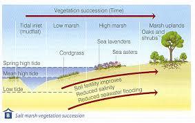
- 62Keyhaven, Hampshire Species-Cordgrass
-Ringed Plover (bird, feeds and nests in salt marsh)
-Sea Lavender
-Oystercatcher (bird, feeds and nests in salt marsh)
-Wold Spider (clings to submerged stems of cordgrass waiting for low tide to bring it food - 63Keyhaven, Hampshire Issues-Salt marsh retreating 6 m a year
-1989 storm breached Hurst Castle Spit, exposing 50 - 80 m that was eroded in 3 months
-Tourism means people could trample, park and pollute the saltmarsh - 64Keyhaven Hampshire Solutions--1996 Rock armour and beach nourishment protected spit £5 m
-Keyhaven is a SSSI and Nation Nature Reserve
Información
- Descripción
- GCSE (Physical Geography) Geography Fichas sobre AQA Geography A Coasts, creado por Natalia Cliff el 20/05/2017.
- Creado por
- Natalia Cliff
- Visitas
- 98
- Etiquetas
- Valoración