
Mapa mental
Rivers
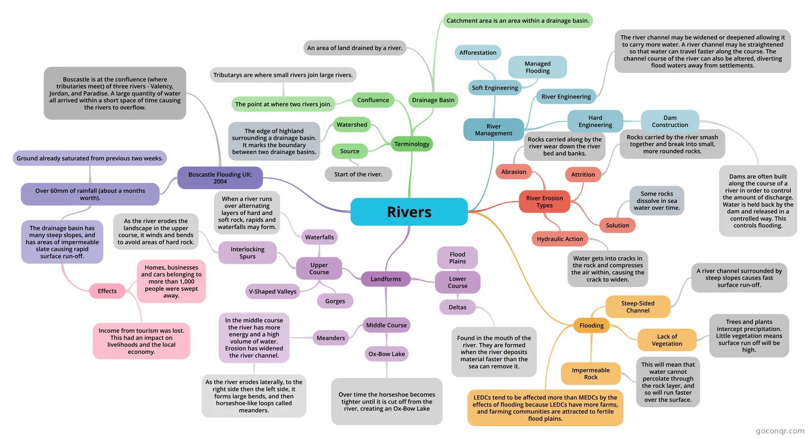
Mind map: Rivers geography
Contenido del mapa
Rivers
Landforms
- Upper Course
- Waterfalls
- When a river runs over alternating layers of hard and soft rock, rapids and waterfalls may form.
- Gorges
- V-Shaped Valleys
- Interlocking Spurs
- As the river erodes the landscape in the upper course, it winds and bends to avoid areas of hard rock.
- Waterfalls
- Middle Course
- Meanders
- In the middle course the river has more energy and a high volume of water. Erosion has widened the river channel.
- As the river erodes laterally, to the right side then the left side, it forms large bends, and then horseshoe-like loops called meanders.
- In the middle course the river has more energy and a high volume of water. Erosion has widened the river channel.
- Ox-Bow Lake
- Over time the horseshoe becomes tighter until it is cut off from the river, creating an Ox-Bow Lake
- Meanders
- Lower Course
- Flood Plains
- Deltas
- Found in the mouth of the river. They are formed when the river deposits material faster than the sea can remove it.
- Upper Course
River Erosion Types
- Hydraulic Action
- Water gets into cracks in the rock and compresses the air within, causing the crack to widen.
- Abrasion
- Rocks carried along by the river wear down the river bed and banks.
- Attrition
- Rocks carried by the river smash together and break into small, more rounded rocks.
- Solution
- Some rocks dissolve in sea water over time.
- Hydraulic Action
Terminology
- Drainage Basin
- An area of land drained by a river.
- Catchment area is an area within a drainage basin.
- Watershed
- The edge of highland surrounding a drainage basin. It marks the boundary between two drainage basins.
- Source
- Start of the river.
- Confluence
- The point at where two rivers join.
- Tributarys are where small rivers join large rivers.
- The point at where two rivers join.
- Drainage Basin
Flooding
- Steep-Sided Channel
- A river channel surrounded by steep slopes causes fast surface run-off.
- Lack of Vegetation
- Trees and plants intercept precipitation. Little vegetation means surface run off will be high.
- Impermeable Rock
- This will mean that water cannot percolate through the rock layer, and so will run faster over the surface.
- LEDCs tend to be affected more than MEDCs by the effects of flooding because LEDCs have more farms, and farming communities are attracted to fertile flood plains.
- Steep-Sided Channel
Boscastle Flooding UK: 2004
- Over 60mm of rainfall (about a months worth).
- Ground already saturated from previous two weeks.
- The drainage basin has many steep slopes, and has areas of impermeable slate causing rapid surface run-off.
- Effects
- Homes, businesses and cars belonging to more than 1,000 people were swept away.
- Income from tourism was lost. This had an impact on livelihoods and the local economy.
- Effects
- Boscastle is at the confluence (where tributaries meet) of three rivers - Valency, Jordan, and Paradise. A large quantity of water all arrived within a short space of time causing the rivers to overflow.
- Over 60mm of rainfall (about a months worth).
River Management
- Hard Engineering
- Dam Construction
- Dams are often built along the course of a river in order to control the amount of discharge. Water is held back by the dam and released in a controlled way. This controls flooding.
- Dam Construction
- Soft Engineering
- Afforestation
- Managed Flooding
- River Engineering
- The river channel may be widened or deepened allowing it to carry more water. A river channel may be straightened so that water can travel faster along the course. The channel course of the river can also be altered, diverting flood waters away from settlements.
- Hard Engineering
Información
- Descripción
- Mapa Mental sobre Rivers, creado por ellie taylor el 04/02/2015.
- Creado por
- ellie taylor
- Visitas
- 2
- Valoración