
Mapa mental
Weather Hazards
Contenido del mapa
Weather Hazards
Global Atmospheric Circulation (GAC)
- Definition
- The movement of air by which heat is distributed on the surface of the earth.
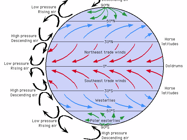
- Global Atomspheric Circulation involves a number of circular air movements called cells, which join together to form the overall circulation of the earth's atmosphere.
- These cells are: the Hadley Cell, the Ferrel Cell and the Polar Cell
- Atmospheric Circulation is also a response to differences in insolation (heat) between high and low latitudes.
- A global pattern of surface winds and pressure belts results from this circulation.
- The patterns of pressure belts and winds are affected by seasonal changes, which cause them to move north during our summer and then south during our winter.
- A global pattern of surface winds and pressure belts results from this circulation.
- Diagram
- How does GAC work?
- Air that is sinking towards the ground surface forms areas of high pressure. Winds on the ground move outwards from these areas.
- An example is at the North Pole.
- Air that is rising from the ground surface forms areas of low pressure on the ground. Winds on the ground move towards these areas of low pressure.
- An example is at the Equator.
- The Wind direction is distorted and deflected due to the Earth's rotation- known as the Coriolis Effect.
- GAC is what drives the world's weather.
- For example, the trade winds in the tropics drive tropical storms.
- Air that is sinking towards the ground surface forms areas of high pressure. Winds on the ground move outwards from these areas.
- Definition
Tropical Storms
- What are Tropical Storms?
- There are several different names for tropical storms; used in different regions of the world.
- In the USA and Carribean, they are called Hurricanes.
- In South-East Asia and Australia, they are called Cyclones.
- In Japan and the Philippines, they are called Typhoons.
- A Tropical Storm ia a large storm that forms over Tropical Oceans.
- They are very powerful and can cause much devastation to small islands and coastal regions.
- There are several different names for tropical storms; used in different regions of the world.
- Where do Tropical Storms Form?
- Tropical Storms form over warm oceans (above 27 degrees).
- Tropical Storms form in the Summer and in the Autumn, when sea temperatures are at their highest.
- Most Tropical Storms form about 5-15 degrees North or South of the Equator.
- This is because, at the Equator, there is not enough 'spin' from the rotation of the Earth, and a Tropical Storm is a spinning mass of clouds.
- In Tropical Regions, the intense heat makes the air unstable, causing it to rise rapidly. These unstable conditions are important for the formation of hurricanes.
- How do Tropical Storms Form?
- 1) A strong upward movement of air draws water vapour up from the warm ocean surface.
- 2) This evaporated air cools as it rises and condenses to form thunderstorm clouds.
- 3) As the air condenses, it releases heat, which powers the storm and draws up more water vapour from the ocean.
- 4) Several small thunderstorms join together to form a gaint spinning storm.
- When Surface winds reach 120 km per hour, the storm becomes a tropical storm.
- 5) The storm develops an eye at the centre, where air descends rapidly. The outer edge of the eye is the eyewall, where there are the most extreme weather conditions.
- 6) The storm is carried across the ocean by prevailing winds and continues to gather strength.
- 7) When the strom reaches land, it's energy supply (evaporated water) is cut off. Friction with the land slows it down and it begins to weaken.
- 6) The storm is carried across the ocean by prevailing winds and continues to gather strength.
- 4) Several small thunderstorms join together to form a gaint spinning storm.
- 3) As the air condenses, it releases heat, which powers the storm and draws up more water vapour from the ocean.
- 2) This evaporated air cools as it rises and condenses to form thunderstorm clouds.
- 1) A strong upward movement of air draws water vapour up from the warm ocean surface.
- What is the structure of a Tropical Storm?
- At the direct centre of the storm there is an eye, which is a small area where relatively cold air sinks and warms up.
- At the eye of the storm, there are no clouds and conditions are calm.
- On either side of the eye is a tall bank of cloud called the eye wall. Here, there are strong winds (excess of 120 km/h), heavy rain, thunder and lightning.
- At the direct centre of the storm there is an eye, which is a small area where relatively cold air sinks and warms up.
- What are Tropical Storms?
Case Study: Typhoon Haiyan | 2013
- Facts about the Hurricane
- Category 5 on the Saffir- Simpson Scale
- Occurred in November 2013
- The hurricane hit the Philippines
- Large areas of coastline and several towns devastated by winds of up to 275 km/h and waves up to 15m.
- One of the strongest storms ever recorded.
- Effects
- City of Tacloban one of the worst affected places- with most of the 220,000 inhabitants left homeless.
- Destruction caused by a 5m high storm surge.
- 90% of Tacloban city destroyed.
- Tacloban Airport terminal was badly damaged
- Primary Effects- impacts of strong winds, heavy rain and storm surge.
- 6300 people killed (mostly drowned by the storm surge)
- Over 600,000 people displaced and 40,000 homes damaged or flattened.
- 30,000 fishing boats destroyed
- Over 400mm of rain caused widespread flooding.
- Strong winds damaged buildings and power lines and destroyed crops.
- Airport terminal badly damaged.
- Secondary Effects- longer-term impacts resulting from primary effects.
- 14 million people affected - with many people left homeless and 6 million lost their source of income.
- Flooding caused landslides and blocked roads, which cut off remote communities.
- Power supplies cut off for a month in some areas.
- Shortages of food, water and shelter- led to outbreaks of disease.
- Looting and violence
- Many jobs were lost as hospitals, shops and schools were damaged- affecting people's livelihoods and education.
- City of Tacloban one of the worst affected places- with most of the 220,000 inhabitants left homeless.
- Responses
- Immediate Responses
- International governments and aid agencies responded with food, water and temporary shelters.
- Over 1200 evacuation shelters set up to help the homeless.
- Field hospitals set up to help the injured.
- The UK government sent shelter kits to provide emergency shelter for families.
- Long-Term responses
- Many countries donated financial aid, supplies and medical support.
- Roads, bridges and airports rebuilt.
- 'Cash for Work' programmes- people paid to clear debris and rebuild the city.
- Oxfam supported the replacement of fishing boats- a vital source of income.
- Thousands of homes rebuilt away from areas at risk from flooding.
- Immediate Responses
- Facts about the Hurricane
Weather Hazards in the UK
- Case Study: The Somerset Levels Floods | 2014
- What caused the floods in 2014?
- It was the wettest January since records began in 1910- about 350mm of rain fell in January and February (100mm above average).
- Rivers had not been dredged for at least 20 years, and so were clogged with sediment.
- High tides and storm surges swept water up the Bristol Channel, which spilled over the riverbanks.
- What were the impacts of the flood?
- Social
- Over 600 houses flooded
- 16 farms evacuated
- Villages cut off
- Power supplies cut off
- Residents evacuated to temporary accommodation for months
- Economic
- Cost of flood damage estimated to be more than £10 million
- Railway line closed
- Over 1000 livestock evacuated
- Local roads cut off by floods
- Environmental
- Stagnant water had to be reoxygenated before being pumped back into rivers
- Debris had to be cleared
- Floodwater heavily contaminated with sewage etc.
- Social
- Immediate Responses
- Local community groups and volunteers gave support
- Boats used to go to school etc
- Long-Term Responses
- Somerset County Council- £20 million flood action plan
- March 2014- rivers Tone and Parrett dredged
- Road levels raised
- River banks raised and strenghened
- More pumping stations built
- What caused the floods in 2014?
- Extreme Weather in the UK
- What are the UK's weather hazards?
- Weather is driven towards the UK by south-westerly prevailing winds.
- Thunderstorms
- Prolonged Rainfall (can lead to flooding)
- Drought and extreme heat
- Strong Winds
- Heavy snow and extreme cold
- Case Study: The Somerset Levels Floods | 2014
Reducing the effects of Tropical Storms
- Monitoring and Prediction
- Hurricane Watch: This warns that hurricane conditions are possible.
- Hurricane Warning: This advises that hurricane conditions are expected and that people should take immediate action.
- Protection
- Reinforcement of windows, doors and roofs to strengthen buildings.
- Construction of storm drains in urban areas to help against flooding.
- Sea walls built to protect important properties from storm surges.
- Houses in coastal areas constructed on stilts to protect them from storm surges.
- In Bangladesh, almost 2000 cyclone shelters have been built.
- Planning
- Planning involves raising individual and community awareness, as people need to understand potential dangers and be able to respond.
- USA- Hurricane Preparedness Week.
- Planning involves raising individual and community awareness, as people need to understand potential dangers and be able to respond.
- Monitoring and Prediction