
Mapa mental
Tectonics
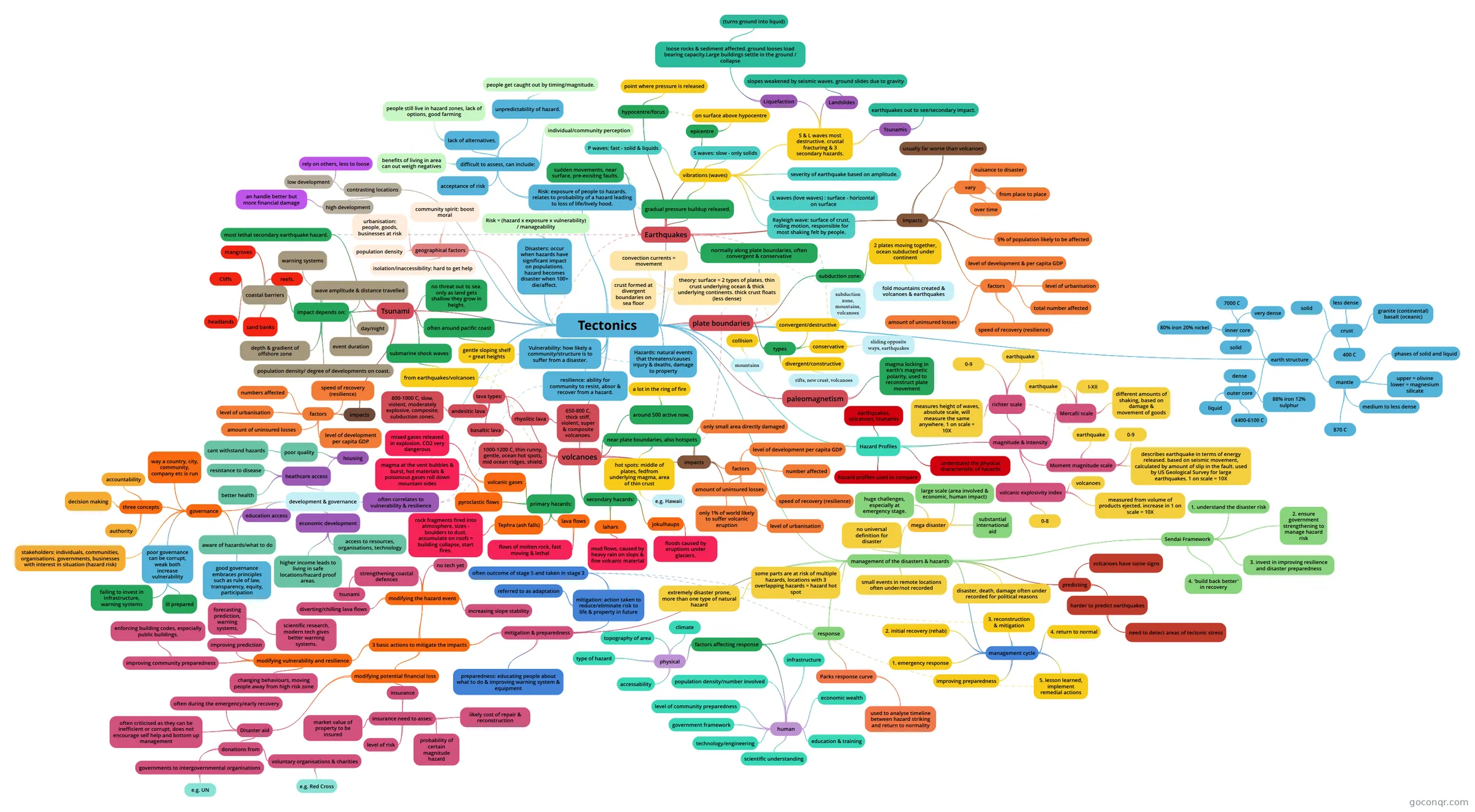
Mind map: Tectonics
Contenido del mapa
Tectonics
plate boundaries
- types
- divergent/constructive
- rifts, new crust, volcanoes
- collision
- mountains
- conservative
- sliding opposite ways, earthquakes
- convergent/destructive
- subduction zone, mountains, volcanoes
- divergent/constructive
- subduction zone:
- 2 plates moving together, ocean subducted under continent
- fold mountains created & volcanoes & earthquakes
- 2 plates moving together, ocean subducted under continent
- types
Earthquakes
- normally along plate boundaries, often convergent & conservative
- sudden movements, near surface, pre-exisitng faults.
- gradual pressure buildup released.
- vibrations (waves)
- L waves (love waves) : surface - horizontal on surface
- S waves: slow - only solids
- P waves: fast - solid & liquids
- severity of earthquake based on amplitude.
- S & L waves most destructive. crustal fracturing & 3 secondary hazards.
- Liquefaction
- loose rocks & sediment affected. ground looses load bearing capacity.Large buildings settle in the ground / collapse
- (turns ground into liquid)
- loose rocks & sediment affected. ground looses load bearing capacity.Large buildings settle in the ground / collapse
- Tsunamis
- earthquakes out to see/secondary impact.
- Landslides
- slopes weakened by seismic waves. ground slides due to gravity
- Liquefaction
- Rayleigh wave: surface of crust, rolling motion, responsible for most shaking felt by people.
- vibrations (waves)
- hypocentre/focus
- point where pressure is released
- epicentre
- on surface above hypocentre
- Impacts
- vary
- over time
- from place to place
- nuisance to disaster
- usually far worse than volcanoes
- 5% of population likely to be affected
- factors
- speed of recovery (resilience)
- total number affected
- level of development & per capita GDP
- amount of uninsured losses
- level of urbanisation
- vary
volcanoes
- around 500 active now.
- a lot in the ring of fire
- near plate boundaries, also hotspots
- hot spots: middle of plates, fedfrom underlying magma, area of thin crust
- e.g. Hawaii
- hot spots: middle of plates, fedfrom underlying magma, area of thin crust
- primary hazards:
- pyroclastic flows
- magma at the vent bubbles & burst, hot materials & poisonous gases roll down mountain sides
- Tephra (ash falls)
- rock fragments fired into atmosphere. sizes - boulders to dust. accumulate on roofs = building collapse, start fires.
- lava flows
- flows of molten rock, fast moving & lethal
- volcanic gases
- mixed gases released in explosion. CO2 very dangerous
- pyroclastic flows
- secondary hazards:
- lahars
- mud flows, caused by heavy rain on slops & fine volcanic material
- jokulhaups
- floods caused by eruptions under glaciers.
- lahars
- impacts
- only small area directly damaged
- only 1% of world likely to suffer volcanic eruption
- factors
- level of development per capita GDP
- number affected
- speed of recovery (resilience)
- amount of uninsured losses
- level of urbanisation
- lava types:
- basaltic lava
- 1000-1200 C, thin runny, gentle, ocean hot spots, mid ocean ridges, shield.
- andesitic lava
- 800-1000 C, slow, violent, moderately explosive, composite, subduction zones.
- rhyolitic lava
- 650-800 C, thick stiff, violent, super & composite volcanoes.
- basaltic lava
- around 500 active now.
Tsunami
- submarine shock waves
- from earthquakes/volcanoes
- often around pacific coast
- gentle sloping shelf = great heights
- most lethal secondary earthquake hazard.
- no threat out to sea. only as land gets shallow they grow in height.
- impact depends on:
- event duration
- wave amplitude & distance travelled
- depth & gradient of offshore zone
- coastal barriers
- mangroves
- headlands
- reefs.
- sand banks
- Cliffs
- day/night
- warning systems
- population density/ degree of developments on coast.
- impacts
- factors
- level of development per capita GDP
- numbers affected
- speed of recovery (resilience)
- amount of uninsured losses
- level of urbanisation
- factors
- submarine shock waves
theory: surface = 2 types of plates. thin crust underlying ocean & thick underlying continents. thick crust floats (less dense)
- crust formed at divergent boundaries on sea floor
- convection currents = movement
paleomagnetism
- magma locking in earth's magnetic polarity, used to reconstruct plate movement
Hazards: natural events that threatens/causes injury & deaths, damage to property
Disasters: occur when hazards have significant impact on populations. hazard becomes disaster when 100+ die/affect.
- Risk = (hazard x exposure x vulnerability) / manageability
Risk: exposure of people to hazards. relates to probability of a hazard leading to loss of life/lively hood.
- difficult to assess, can include:
- individual/community perception
- unpredictability of hazard.
- people get caught out by timing/magnitude.
- lack of alternatives.
- people still live in hazard zones, lack of options, good farming
- benefits of living in area can out weigh negatives
- acceptance of risk
- difficult to assess, can include:
Vulnerability: how likely a community/structure is to suffer from a disaster.
resilience: ability for community to resist, absor & recover from a hazard.
Hazard Profiles
- magnitude & intensity
- richter scale
- earthquake
- 0-9
- measures height of waves, absolute scale, will measure the same anywhere. 1 on scale = 10X
- Mercalli scale
- earthquake
- I-XII
- different amounts of shaking, based on damage & movement of goods
- Moment magnitude scale
- earthquake
- 0-9
- describes earthquake in terms of energy released. based on seismic movement, calculated by amount of slip in the fault. used by US Geological Survey for large earthquakes. 1 on scale = 10X
- volcanic explosivity index
- volcanoes
- 0-8
- measured from volume of products ejected. increase in 1 on scale = 10X
- richter scale
- hazard profiles used to compare
- understand the physical characteristic of hazards
- earthquakes, volcanoes, tsunamis
- magnitude & intensity
development & governance
- often correlates to vulnerability & resilience
- economic development
- access to resources, organisations, technology
- higher income leads to living in safe locations/hazard proof areas.
- education access
- aware of hazards/what to do
- heathcare access
- better health
- resistance to disease
- housing
- poor quality
- cant withstand hazards
- poor quality
- governance
- way a country, city, community, company etc is run
- three concepts
- authority
- decision making
- accountability
- good governance embraces principles such as rule of law, transparency, equity, participation
- poor governance can be corrupt, weak both increase vulnerability
- failing to invest in infrastructure, warning systems
- ill prepared
- stakeholders: individuals, communities, organisations. governments, businesses with interest in situation (hazard risk)
geographical factors
- population density
- urbanisation: people, goods, businesses at risk
- isolation/inaccessibility: hard to get help
- community spirit: boost moral
contrasting locations
- high development
- an handle better but more financial damage
- low development
- rely on others, less to loose
- high development
management of the disasters & hazards
- mega disaster
- large scale (area involved & economic, human impact)
- huge challenges, especially at emergency stage.
- substantial international aid
- no universal definition for disaster
- small events in remote locations often under/not recorded
- disaster, death, damage often under recorded for political reasons
- some parts are at risk of multiple hazards, locations with 3 overlapping hazards = hazard hot spot
- extremely disaster prone, more than one type of natural hazard
- predicting
- volcanoes have some signs
- harder to predict earthquakes
- need to detect areas of tectonic stress
- management cycle
- 3. reconstruction & mitigation
- 2. initial recovery (rehab)
- 1. emergency response
- 5. lesson learned, implement remedial actions
- 4. return to normal
- improving preparedness
- mitigation & preparedness
- preparedness: educating people about what to do & improving warning system & equipment
- mitigation: action taken to reduce/eliminate risk to life & property in future
- often outcome of stage 5 and taken in stage 3
- referred to as adaptation
- 3 basic actions to mitigate the impacts
- modifying the hazard event
- no tech yet
- strengthening coastal defences
- tsunami
- diverting/chilling lava flows
- increasing slope stability
- modifying vulnerability and resilience
- improving prediction
- forecasting prediction, warning systems,
- scientific research, modern tech gives better warning systems.
- forecasting prediction, warning systems,
- improving community preparedness
- enforcing building codes, especially public buildings.
- changing behaviours, moving people away from high risk zone
- improving prediction
- modifying potential financial loss
- insurance
- insurance need to asses:
- level of risk
- probability of certain magnitude hazard
- market value of property to be insured
- likely cost of repair & reconstruction
- insurance need to asses:
- Disaster aid
- often during the emergency/early recovery
- donations from
- voluntary organisations & charities
- e.g. Red Cross
- governments to intergovernmental organisations
- e.g. UN
- voluntary organisations & charities
- often criticised as they can be inefficient or corrupt, does not encourage self help and bottom up management
- insurance
- modifying the hazard event
- response
- factors affecting response
- physical
- type of hazard
- topography of area
- climate
- accessability
- human
- scientific understanding
- level of community preparedness
- technology/engineering
- population density/number involved
- education & training
- economic wealth
- infrastructure
- government framework
- physical
- Parks response curve
- used to analyse timeline between hazard striking and return to normality
- factors affecting response
- Sendai Framework
- 1. understand the disaster risk
- 2. ensure government strengthening to manage hazard risk
- 3. invest in improving resilience and disaster preparedness
- 4. 'build back better' in recovery
- mega disaster
earth structure
- inner core
- 7000 C
- very dense
- 80% iron 20% nickel
- solid
- mantle
- 870 C
- medium to less dense
- upper = olivine lower = magnesium silicate
- phases of solid and liquid
- crust
- 400 C
- less dense
- granite (continental) basalt (oceanic)
- solid
- outer core
- 4400-6100 C
- dense
- 88% iron 12% sulphur
- liquid
- inner core
Información
- Descripción
- Mapa Mental sobre Tectonics, creado por Louis Gibson el 25/11/2018.
- Creado por
- Louis Gibson
- Visitas
- 21
- Valoración