
Mapa mental
Coastal landscapes EQ2
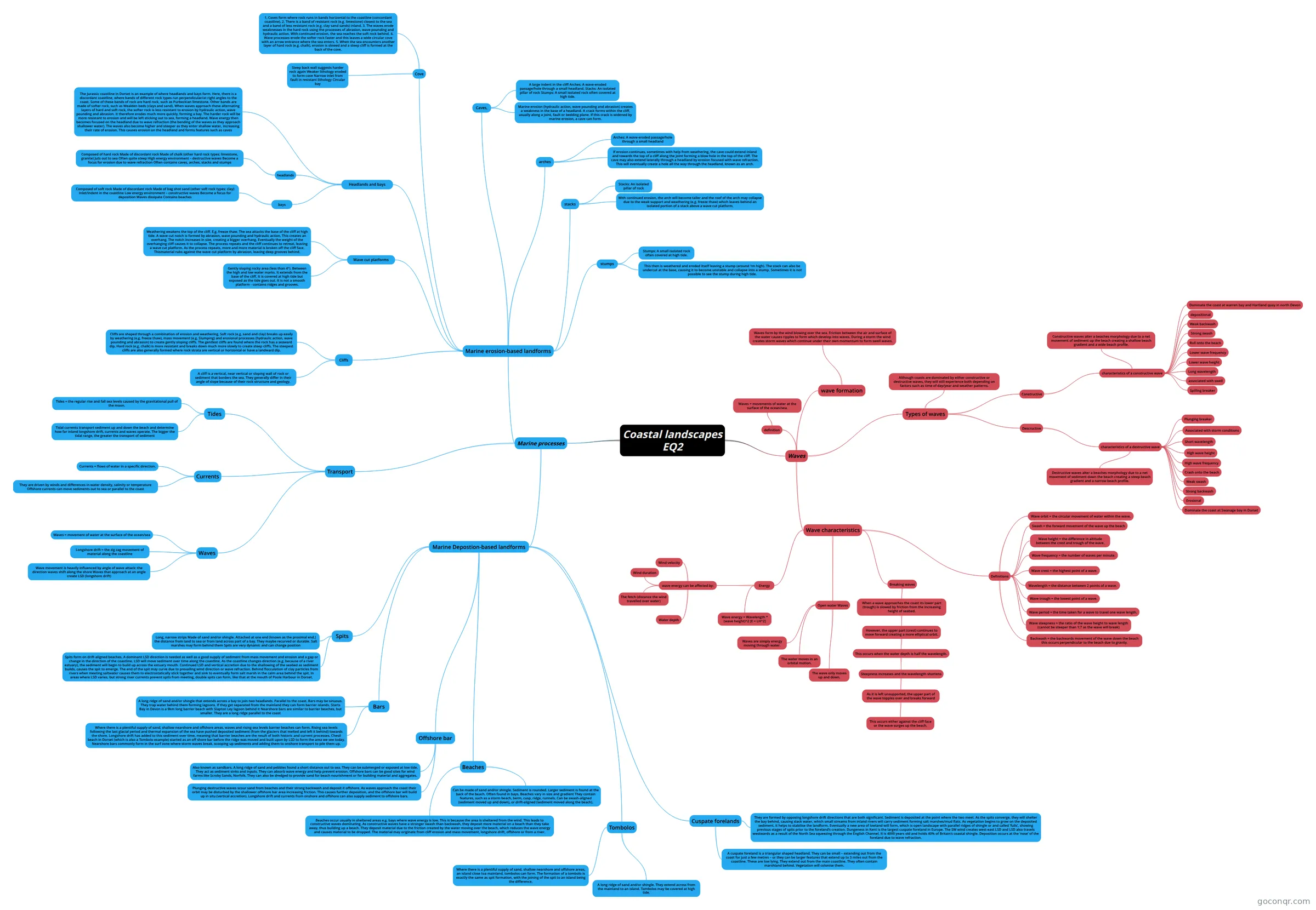
Mind map: Coastal landscapes and marine processes
Contenido del mapa
Coastal landscapes EQ2
Waves
- wave formation
- Waves form by the wind blowing over the sea. Friction between the air and surface of the water causes ripples to form which develop into waves. During a storm the wind creates storm waves which continue under their own momentum to form swell waves.
- Wave characteristics
- Energy
- wave energy can be affected by:
- Wind velocity
- Wind duration
- The fetch (distance the wind travelled over water)
- Water depth
- Wave energy = Wavelength * (wave height)^2 [E = LH^2]
- wave energy can be affected by:
- Open water Waves
- Waves are simply energy moving through water.
- The wave only moves up and down.
- The water moves in an orbital motion.
- Breaking waves
- When a wave approaches the coast its lower part (trough) is slowed by friction from the increasing height of seabed.
- However, the upper part (crest) continues to move forward creating a more elliptical orbit.
- This occurs when the water depth is half the wavelength.
- Steepness increases and the wavelength shortens
- As it is left unsupported, the upper part of the wave topples over and breaks forward
- This occurs either against the cliff face or the wave surges up the beach.
- As it is left unsupported, the upper part of the wave topples over and breaks forward
- Steepness increases and the wavelength shortens
- This occurs when the water depth is half the wavelength.
- However, the upper part (crest) continues to move forward creating a more elliptical orbit.
- When a wave approaches the coast its lower part (trough) is slowed by friction from the increasing height of seabed.
- Definitions
- Wave height = the difference in altitude between the crest and trough of the wave.
- Wave frequency = the number of waves per minute.
- Wave crest = the highest point of a wave.
- Wavelength = the distance between 2 points of a wave.
- Wave trough = the lowest point of a wave.
- Wave period = the time taken for a wave to travel one wave length.
- Wave steepness = the ratio of the wave height to wave length (cannot be steeper than 1:7 as the wave will break)
- Swash = the forward movement of the wave up the beach
- Backwash = the backwards movement of the wave down the beach this occurs perpendicular to the beach due to gravity.
- Wave orbit = the circular movement of water within the wave.
- Energy
- Types of waves
- Although coasts are dominated by either constructive or destructive waves, they will still experience both depending on factors such as time of day/year and weather patterns.
- Constructive
- characteristics of a constructive wave
- Spilling breaker
- associated with swell
- Long wavelength
- Lower wave height
- Lower wave frequency
- Roll onto the beach
- Strong swash
- Weak backwash
- depositional
- Dominate the coast at warren bay and Hartland quay in north Devon
- Constructive waves alter a beaches morphology due to a net movement of sediment up the beach creating a shallow beach gradient and a wide beach profile.
- characteristics of a constructive wave
- Descructive
- characteristics of a destructive wave
- Erosional
- Strong backwash
- Weak swash
- Crash onto the beach
- High wave frequency
- High wave height
- Short wavelength
- Associated with storm conditions
- Dominate the coast at Swanage bay in Dorset
- Plunging breaker
- Destructive waves alter a beaches morphology due to a net movement of sediment down the beach creating a steep beach gradient and a narrow beach profile.
- characteristics of a destructive wave
- definition
- Waves = movements of water at the surface of the ocean/sea.
- wave formation
Marine processes
- Marine erosion-based landforms
- Cliffs
- A cliff is a vertical, near vertical or sloping wall of rock or sediment that borders the sea. They generally differ in their angle of slope because of their rock structure and geology.
- Cliffs are shaped through a combination of erosion and weathering. Soft rock (e.g. sand and clay) breaks up easily by weathering (e.g. freeze thaw), mass movement (e.g. Slumping) and erosional processes (hydraulic action, wave pounding and abrasion) to create gently sloping cliffs. The gentlest cliffs are found where the rock has a seaward dip. Hard rock (e.g. chalk) is more resistant and breaks down much more slowly to create steep cliffs. The steepest cliffs are also generally formed where rock strata are vertical or horizontal or have a landward dip.
- Wave cut platforms
- Gently sloping rocky area (less than 4°). Between the high and low water marks. It extends from the base of the cliff. It is covered at high tide but exposed as the tide goes out. It is not a smooth platform - contains ridges and grooves.
- Weathering weakens the top of the cliff. E.g. freeze thaw. The sea attacks the base of the cliff at high tide. A wave cut notch is formed by abrasion, wave pounding and hydraulic action. This creates an overhang. The notch increases in size, creating a bigger overhang. Eventually the weight of the overhanging cliff causes it to collapse. The process repeats and the cliff continues to retreat, leaving a wave cut platform. As the process repeats, more and more material is broken off the cliff face. Thismaterial rubs against the wave cut platform by abrasion, leaving deep grooves behind.
- Headlands and bays
- headlands
- Composed of hard rock Made of discordant rock Made of chalk (other hard rock types: limestone, granite) Juts out to sea Often quite steep High energy environment – destructive waves Become a focus for erosion due to wave refraction Often contains caves, arches, stacks and stumps
- bays
- Composed of soft rock Made of discordant rock Made of bag shot sand (other soft rock types: clay) Inlet/indent in the coastline Low energy environment – constructive waves Become a focus for deposition Waves dissipate Contains beaches
- The Jurassic coastline in Dorset is an example of where headlands and bays form. Here, there is a discordant coastline, where bands of different rock types run perpendicular/at right angles to the coast. Some of these bands of rock are hard rock, such as Purbeckian limestone. Other bands are made of softer rock, such as Wealden beds (clays and sand). When waves approach these alternating layers of hard and soft rock, the softer rock is less resistant to erosion by hydraulic action, wave pounding and abrasion. It therefore erodes much more quickly, forming a bay. The harder rock will be more resistant to erosion and will be left sticking out to sea, forming a headland. Wave energy then becomes focused on the headland due to wave refraction (the bending of the waves as they approach shallower water). The waves also become higher and steeper as they enter shallow water, increasing their rate of erosion. This causes erosion on the headland and forms features such as caves
- headlands
- Cove
- Steep back wall suggests harder rock again Weaker lithology eroded to form cove Narrow inlet from fault in resistant lithology Circular bay
- 1. Coves form where rock runs in bands horizontal to the coastline (concordant coastline). 2. There is a band of resistant rock (e.g. limestone) closest to the sea and a band of less resistant rock (e.g. clay sand sands) inland. 3. The waves erode weaknesses in the hard rock using the processes of abrasion, wave pounding and hydraulic action. With continued erosion, the sea reaches the soft rock behind. 4. Wave processes erode the softer rock faster and this leaves a wide circular cove with an arrow entrance where the sea enters. 5. When the sea encounters another layer of hard rock (e.g. chalk), erosion is slowed and a steep cliff is formed at the back of the cove.
- Caves,
- A large indent in the cliff Arches: A wave-eroded passage/hole through a small headland. Stacks: An isolated pillar of rock Stumps: A small isolated rock often covered at high tide.
- Marine erosion (hydraulic action, wave pounding and abrasion) creates a weakness in the base of a headland. A crack forms within the cliff, usually along a joint, fault or bedding plane. If this crack is widened by marine erosion, a cave can form.
- arches
- Arches: A wave-eroded passage/hole through a small headland
- If erosion continues, sometimes with help from weathering, the cave could extend inland and towards the top of a cliff along the joint forming a blow hole in the top of the cliff. The cave may also extend laterally through a headland by erosion focused with wave refraction. This will eventually create a hole all the way through the headland, known as an arch.
- stacks
- Stacks: An isolated pillar of rock
- With continued erosion, the arch will become taller and the roof of the arch may collapse due to the weak support and weathering (e.g. freeze thaw) which leaves behind an isolated portion of a stack above a wave cut platform.
- stumps
- Stumps: A small isolated rock often covered at high tide.
- This then is weathered and eroded itself leaving a stump (around 1m high). The stack can also be undercut at the base, causing it to become unstable and collapse into a stump. Sometimes it is not possible to see the stump during high tide.
- Cliffs
- Transport
- Tides
- Tides = the regular rise and fall sea levels caused by the gravitational pull of the moon.
- Tidal currents transport sediment up and down the beach and determine how far inland longshore drift, currents and waves operate. The bigger the tidal range, the greater the transport of sediment
- Waves
- Waves = movement of water at the surface of the ocean/sea
- Wave movement is heavily influenced by angle of wave attack: the direction waves shift along the shore Waves that approach at an angle create LSD (longshore drift)
- Longshore drift = the zig zag movement of material along the coastline
- Currents
- Currents = flows of water in a specific direction.
- They are driven by winds and differences in water density, salinity or temperature Offshore currents can move sediments out to sea or parallel to the coast
- Tides
- Marine Depostion-based landforms
- Spits
- Long, narrow strips Made of sand and/or shingle. Attached at one end (known as the proximal end.) the distance from land to sea or from land across part of a bay. They maybe recurved or durable. Salt marshes may form behind them Spits are very dynamic and can change position
- Spits form on drift-aligned beaches. A dominant LSD direction is needed as well as a good supply of sediment from mass movement and erosion and a gap or change in the direction of the coastline. LSD will move sediment over time along the coastline. As the coastline changes direction (e.g. because of a river estuary), the sediment will begin to build up across the estuary mouth. Continued LSD and vertical accretion due to the shallowing of the seabed as sediment builds, causes the spit to emerge. The end of the spit may curve due to prevailing wind direction or wave refraction. Behind flocculation of clay particles from rivers when meeting saltwater causes them to electrostatically stick together and sink to eventually form salt marsh in the calm area behind the spit. In areas where LSD varies, but strong river currents prevent spits from meeting, double spits can form, like that at the mouth of Poole Harbour in Dorset.
- Bars
- A long ridge of sand and/or shingle that extends across a bay to join two headlands. Parallel to the coast. Bars may be sinuous. They trap water behind them forming lagoons. If they get separated from the mainland they can form barrier islands. Starts Bay in Devon is a 9km long barrier beach with Slapton Ley lagoon behind it Nearshore bars are similar to barrier beaches, but smaller. They are a long ridge parallel to the coast
- Where there is a plentiful supply of sand, shallow nearshore and offshore areas, waves and rising sea levels barrier beaches can form. Rising sea levels following the last glacial period and thermal expansion of the sea have pushed deposited sediment (from the glaciers that melted and left it behind) towards the shore. Longshore drift has added to this sediment over time, meaning that barrier beaches are the result of both historic and current processes. Chesil beach in Dorset (which is also a Tombolo example) started as an off shore bar before the ridge was moved and built upon by LSD to form the area we see today. Nearshore bars commonly form in the surf zone where storm waves break, scooping up sediments and adding them to onshore transport to pile them up.
- Offshore bar
- Also known as sandbars. A long ridge of sand and pebbles found a short distance out to sea. They can be submerged or exposed at low tide. They act as sediment sinks and inputs. They can absorb wave energy and help prevent erosion. Offshore bars can be good sites for wind farms like Scroby Sands, Norfolk. They can also be dredged to provide sand for beach nourishment or for building material and aggregates.
- Plunging destructive waves scour sand from beaches and their strong backwash and deposit it offshore. As waves approach the coast their orbit may be disturbed by the shallower offshore bar area increasing friction. This causes further deposition, and the offshore bar will build up in situ (vertical accretion). Longshore drift and currents from onshore and offshore can also supply sediment to offshore bars.
- Tombolos
- A long ridge of sand and/or shingle. They extend across from the mainland to an island. Tombolos may be covered at high tide.
- Where there is a plentiful supply of sand, shallow nearshore and offshore areas, an island close toa mainland, tombolos can form. The formation of a tombolo is exactly the same as spit formation, with the joining of the spit to an island being the difference.
- Cuspate forelands
- A cuspate foreland is a triangular shaped headland. They can be small – extending out from the coast for just a few metres – or they can be larger features that extend up to 3 miles out from the coastline. These are low lying. They extend out from the main coastline. They often contain marshland behind. Vegetation will colonise them.
- They are formed by opposing longshore drift directions that are both significant. Sediment is deposited at the point where the two meet. As the spits converge, they will shelter the bay behind, causing slack water, which small streams from inland rivers will carry sediment forming salt marshes/mud flats. As vegetation begins to grow on the deposited sediment, it helps to stabilise the landform. Eventually a new area of lowland will form, which is open landscape with parallel ridges of shingle or and called ‘fulls’, showing previous stages of spits prior to the foreland’s creation. Dungeness in Kent is the largest cuspate foreland in Europe. The SW wind creates west-east LSD and LSD also travels westwards as a result of the North Sea squeezing through the English Channel. It is 4000 years old and holds 40% of Britain’s coastal shingle. Deposition occurs at the ‘nose’ of the foreland due to wave refraction.
- Beaches
- Can be made of sand and/or shingle. Sediment is rounded. Larger sediment is found at the back of the beach. Often found in bays. Beaches vary in size and gradient They contain features, such as a storm beach, berm, cusp, ridge, runnels. Can be swash-aligned (sediment moved up and down), or drift-aligned (sediment moved along the beach).
- Beaches occur usually in sheltered areas e.g. bays where wave energy is low. This is because the area is sheltered from the wind. This leads to constructive waves dominating. As constructive waves have a stronger swash than backwash, they deposit more material on a beach than they take away, thus building up a beach. They deposit material due to the friction created by the water moving over the beach, which reduces the wave energy and causes material to be dropped. The material may originate from cliff erosion and mass movement, longshore drift, offshore or from a river.
- Spits
- Marine erosion-based landforms
Información
- Descripción
- A level A level Geography Mapa Mental sobre Coastal landscapes EQ2, creado por Kai Taylor el 04/11/2025.
- Creado por
- Kai Taylor
- Visitas
- 1
- Valoración