2155001
Description
Flashcards by hajrahali.ha, updated more than 1 year ago
|
|
Created by hajrahali.ha
almost 11 years ago
|
|
| Question | Answer |
| Mercalli Scale | Used to indicate the intensity of an earthquake. It classifies the effect of an earth quake on a scale using Roman Numerals for I to XII. Also takes in the effects on the earths surface conservation. |
| Richter Scale | Measures the strength or magnitude of an earthquake |
| Seismometer | A machine which records the strength of an earthquake. It picks up vibrations and tremors during an earthquake producing a seismograph. |
| Focus | The point below the earth's surface where pressure is released. |
| Epicenter | The point on the earth's surface directly above the focus. |
| Shockwaves (Seismic waves) | Produced when pressure is released from the focus. |
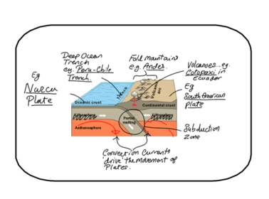
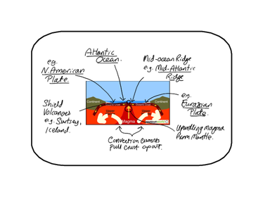
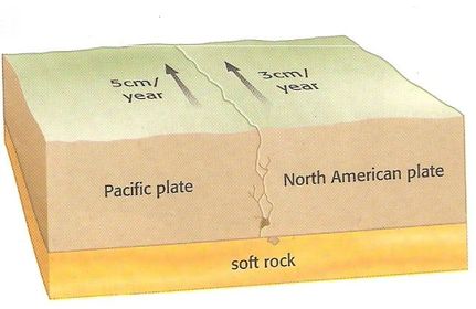
| Examples of plate boundaries: Destructive Constructive Collision Conservative | Nazca and South American Plate Eurasian and North American Plate Eurasian and Indo-Australian Plate Pacific and North American Plate |
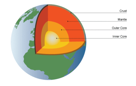
| Layers of the Earth | |
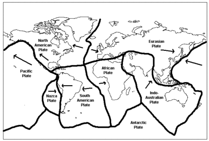
| Plates | |
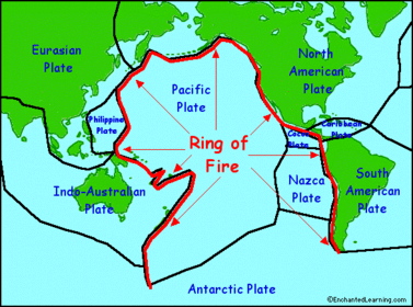
| Ring Of Fire | |
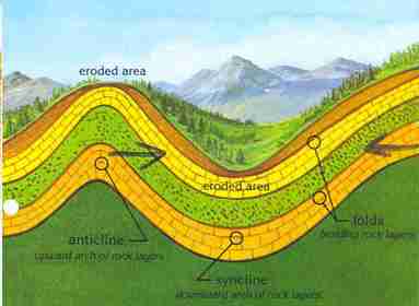
| Collision Plate Margins Fold mountains and earthquakes | Two plates of equal density push toward each, in result fold mountains are created. Examples: The Alps |
| Destructive Plate Margin Earthquakes, fold mountains and volcanoes | Heavier plate subducts causing magma to increase pressure causing fierce volcanic eruptions |
| Conservative Plate Margin Volcanoes/Volcanic Islands | Convection currents force plates apart, magma rises and cools in gaps forming new crust. |
| Conservative Plate Margin Earthquakes | Plates move against each other causing friction, pressure released as an earthquake. |
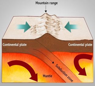
| Fold Mountains | |
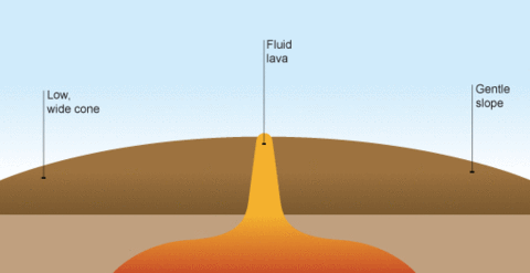
| Shield Volcano | Constructive or tension margins. Low, sloping sides formed by eruptions of thin lava eruptions frequent- gentle |
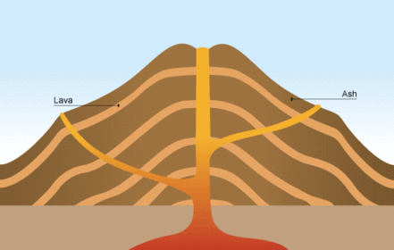
| Composite Volcano | Different layers, lava and ash. Destructive or compression margins. Eruptions = pyroclastic flow |
| What did Alfred Wegner propose? | He proposed that all the continents were once joint together as a huge continent, Pangaea. Evidence of this is: fossils, rock types and the shape of continents now. However he didn't have any more evidence to explain his theory. |
| How have humans adapted to living in fold mountains | - Tourism all year around - Hydro-electric power - Farming - Dairy farming |
| Farming In The Alps | Valley floor- flat land, deep fertile soil, sheltered from wind, access and communication. Dairy farming- summer= high alps and winter= large barns Hay in summer grown on valley floor |
| Hydro-electric power The Alps | Steep slopes, fast flowing rivers, high rainfall, snow melts in summer- ideal for HEP. |
| Human Activity The Alps | Tourism- led to buildings of roads, tunnels, avalanche shelters, hotels, restaurants etc. Benefits locals. Features- winter scenery, summer resort, winter sports, alpine climate, communication, close to affluent areas. |
| Problems caused by fold mountains The Alps | - Low population - Cold, wet climate - Short growing season -Avalanches |
| Characteristics of a shield volcano | -Cone with wide base, gentle slopes. -Made of lava only. -Regular and frequent eruptions -Lava pours out, little violence |
| Characteristics of a composite cone volcano | -Tall cone with narrow base and steep sides -Made of alternate layers of lava and ash -Irregular with long periods of dormancy -Violent explosions |
| Earthquake case studies | MEDC: Seattle, USA, 2001 Richter scale: 6.8 LEDC: Gujarat, India, 2001 Richter scale: 7.9 |
| Tsunami case study | The Asian Tsunami, 2004 Indonesia, Thailand, India, Sri Lanka and elsewhere Magnitude: 8.9 |
| Volcano case study | Soufriere Hills, Montserrat July 1995 Capital city: Plymouth |
| Super-volcano | Yellowstone Last erupted about 2 million years ago Volcanic ash covered more than half of North America |
| What is a supervolcano? | A supervolcano is a volcano on a massive scale. -Erupts at least 1,000 km3 of material -Forms a depression, called a caldera -Often has a ridge of higher land -Eruptions are hundreds of thousands of years apart |
| Can volcanoes be predicted? Sometimes | -Tremors, small quakes -Gas emissions e.g CO2, SO2 -Temp change of water -Bulges, shape might change |
| How do you prepare for an earthquake? | -Educate people about eq's -Prepare for eq's e.g food kits -Sometimes seismometers can be used but are not accurate. -Build roads and buildings to withstand the eq. Reduces damage and maybe deaths |
| What is a Tsunami? | waves triggered by underwater earthquakes, the rate of travel is between 400-600 mph The closer to land they get the higher the waves due to speed decreasing at the front but still fast behind |
Want to create your own Flashcards for free with GoConqr? Learn more.