733961
Description
Mind Map by sophieelizabeth, updated more than 1 year ago
|
|
Created by sophieelizabeth
over 11 years ago
|
|
Geography
Restless Earth
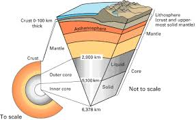
- The Earth is made up of different layers
- Continental crust (Granite)
and oceanic crust(Basalt) are
both solid and can reach to
900°C
- asthenosphere (peridotites) is partially molten
and it is between 100-1600°c
- Mantle (silica- based minerals) is solid and is
between 1600-4000°c
- Outer Core (iron/nickel) is a very dense
liquid and is between 4000-5000°C
- Inner core (iron/nickel) is a very dense
solid and is between 4000-5000°C
- Continental crust (Granite)
and oceanic crust(Basalt) are
both solid and can reach to
900°C
- The two types of crust
- Continental crust - Makes up most of
the land area of the earth. It is
dominated by rocks that cooled below the
surface, such as granite. It is between
25 km and 80km thick
- Oceanic crust is much thinner,
between 6kn and 8km. It is made up
of rocks like basalt
- Continental crust - Makes up most of
the land area of the earth. It is
dominated by rocks that cooled below the
surface, such as granite. It is between
25 km and 80km thick
- Convection Currents
- High temperatures in the
core create rising limbs of
material in the mantle,
called convection currents
- Some of the material
moves in sheets
creating movement in
the crust above it
- In other places in rises in
columns, creating hotspots
- High temperatures in the
core create rising limbs of
material in the mantle,
called convection currents
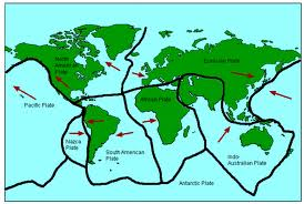
- Different plate boundries
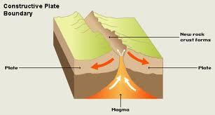
- Constructive Margins are formed by rising magma
splitting up continental crust and forming new
oceans. An example of this is where the Eurasian
plate is separating slowly from the North-American
plate.
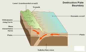
- Destructive margins are formed when oceanic plates collide with continental plates. the
oceanic plate sinks beneath the continental plate. This is called subduction and it creates a
very deep ocean trenches near the line of contact. Some of the lightweight materials in the
oceanic plate begin to melt because of the hotter temperature in the mantle and begin to
rise to the surface to form volcanoes An example of this is where the South American plate
meets the Nazca Plate
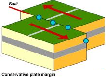
- Conservative margins are formed when
plates slide past each other or move in the
same direction but at different speeds. No
crust is formed or destroyed, and volcanoes
are not formed. However great strain builds
up along the junction, with sudden lurches
along the fault. Meaning earthquakes are
frequent and often large. An example of this
is the San andreas fault
- Constructive Margins are formed by rising magma
splitting up continental crust and forming new
oceans. An example of this is where the Eurasian
plate is separating slowly from the North-American
plate.
- Impact of a hazard
- The size of the event
- Vurnilability of population
- How prepared the population are
- The size of the event
- Volcanoes
- Composite volcanoes are steep-sided which takes up a small area. It has alternate layers of ash
and lava. the magma/lava is very viscous and sticky. iThey erupt very infrequently and sometimes
very unpredictable. Pressure builds up over tmie. An example would be Mt Pinatubo (Philippines)
- Shield volcanoes are gentle sloped (like a shield) which take up a large area. The magma is
very fluid and flows quickly. They erupt very frequently but are generally gentle eruptions. An
example would be Mauna Loa (Hawaii, USA)
- Volcanoes can be active, dormant or extinct
- Composite volcanoes are steep-sided which takes up a small area. It has alternate layers of ash
and lava. the magma/lava is very viscous and sticky. iThey erupt very infrequently and sometimes
very unpredictable. Pressure builds up over tmie. An example would be Mt Pinatubo (Philippines)
- Earthquakes
- A number of factors control the severity of an earthquake.
- The magnitude of the earthquake on the
Richter scale
- The depth (shallow earthquakes are more destructive)
- The magnitude of the earthquake on the
Richter scale
- The impact of earthquakes varies according to:
- The time of the day
- The distance from the epicentre
- The level of preparedness
- The quality of the emergency services
- The time of the day
- Primary impants - the immedediate effect of an earthquake on
property and people. For earthquakes this is the people killed as a
result of the shaking and property destruction
- Secondary impacts - the impact on property and people of an event after it has finished.
Lack of shelter and basic supplies, as well as fires, are frequent secondary effects
- A number of factors control the severity of an earthquake.
- Predicting natural disasters
- Volcanic eruptions and tsunamis can be predicted
if the right equipment is used
- Gas emissions, earth tremors and "bulging" of a volcano's flanks
can be measured and used to predict eruptions
- In 1991 about 120,000 people were
evacuated from the area around Mt
Pinatubo before it erupted
- Tsunami warning sirens can be used to evacuate
people from coasts before a tsunami wave hits
- Earthquakes cannot be predicted. However
being prepared can minimise damage
- Emergancy plans
- Well trained ad funded emergency services.
- Warning systems
- Evacuation routes
- Emergancy plans
- Volcanic eruptions and tsunamis can be predicted
if the right equipment is used
Media attachments
Want to create your own Mind Maps for free with GoConqr? Learn more.