
Mind map
Montserrat
Map content
Montserrat
CAUSES
- North American Plate and Caribbean Plate
- Destructive plate boundary
- North American Plate and Caribbean Plate
About
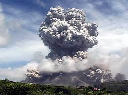
- After 200 years of dormancy, eruptions began in 1995
- Big eruption in June 1997
- In the Soufriere Hills
EFFECTS
- Primary
- 23 dead, 7 injured
- Hospitals, buildings destoyed
- Communications down
- Plymouth buried in about 12m ash and mud!
- Secondary
- Tourism declined
- The economy failed- electrical goods couldn't be imported as the buildings were damaged, and the crops had failed
- However soil fertility improved from volcanic ash
- Volcano tourism developed and tourist returning
- Primary
RESPONSES
- Immediate
- UK sent £17m in emergency aid
- 5000 people left the island for the UK or Antigua
- South of island declared as exclusion zone and everyone evacuated to the North
- USGS scientists set up seismometers to monitor volcano
- Long Term
- UK gave £41m to aid in rebuilding docks and an airport which was opened in 2005
- Volcano advertised and tourists invited to see the modern day Pompeii
- Little Bay town built in the north to replace Plymouth
- The MVO set up to monitor the volcano
- Immediate