372453
Description

Mind Map by Henry Kitchen, updated more than 1 year ago
|
|
Created by Henry Kitchen
about 12 years ago
|
|
Ice on
the land
- Ice ages
- An Ice Age is a period of
time in which part of the
surface of the Earth is
covered in ice permanently.
- The last ice age was called the Pleistocene age (not plasticene!) and it
began approximately 2 million years ago. We are still (technically) in the
Pleistocene age. The pleistocene age's peak was around 18,000 years B.P.
(before present; actually means before the year 1950) and at this point, 30%
of the Earth's surface was covered in ice permeanently. During this time,
Earth's mean temperature fluctuated significantly between warm periods,
known as "interglacial periods" and cold periods, known as "glacial periods".
Fom both ice cores and deep sea sediment, we can tell that there have been
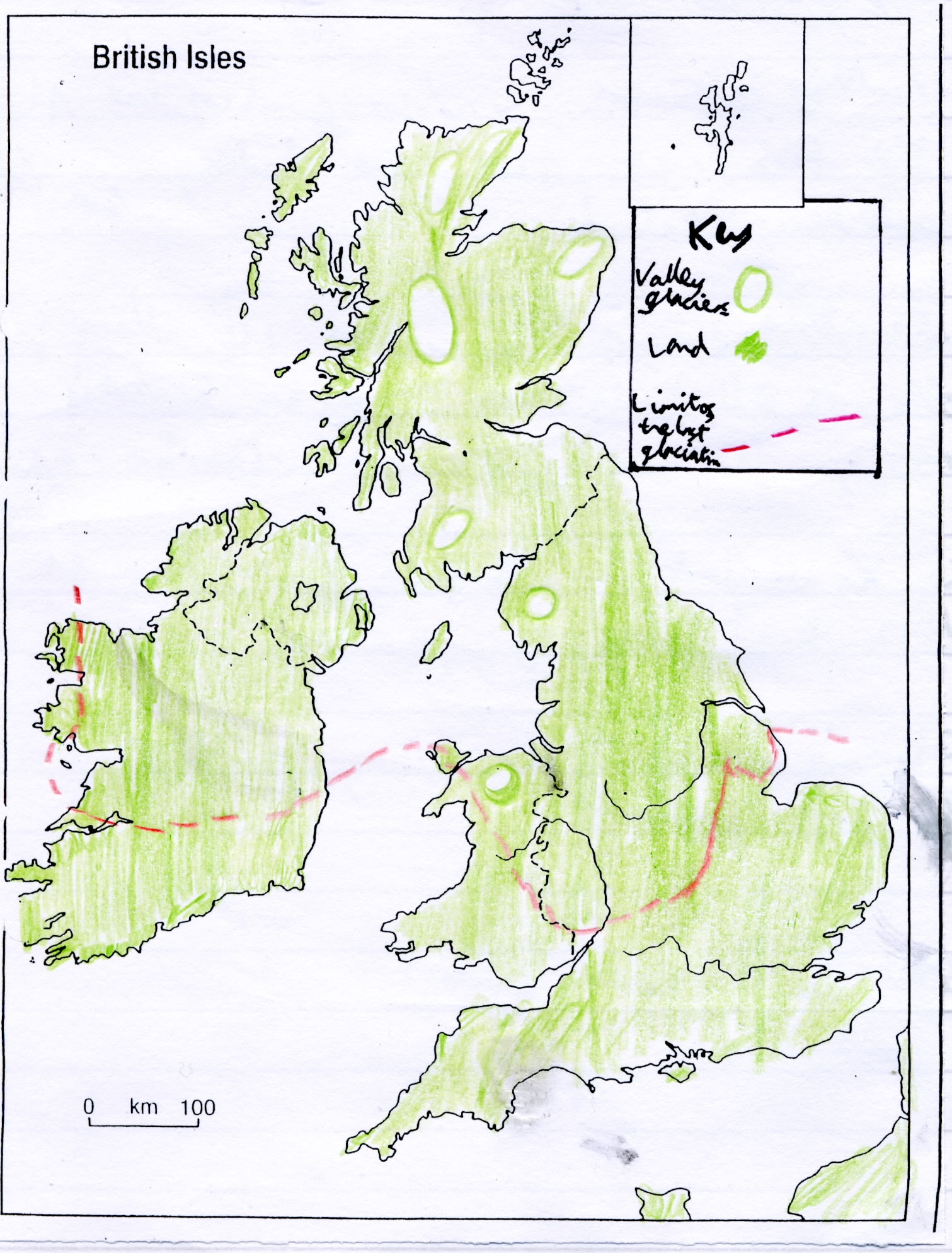
around 20 cold periods. During the Pleistocene age, the UK was covered in
2-3km of solid ice.
- A map showing valley glaciers
and the limit of the Pleistocene
glaciation (bit scruffy, I made it
after all!)
- An Ice Age is a period of
time in which part of the
surface of the Earth is
covered in ice permanently.
- The amount of ice on Earth depends on
the glacial budget; the glacial budget is
the net result of accumulation and
ablation. Accumulation is basically the
amount of precipitation and moraine are
inputted into the glacial system, and
ablation is how much is lost to global
warming, friction and other factors.
- Current global ice cover
- Ice now covers only
10% of Earth on a
permanent basis. This
ice is found in 2 main
areas, the first being
areas of high latitude
(above 66° south or
north) and the second
being areas of high
altitude (high in the
mountains).
- An ice sheet is an area of
ice with an area of 50,000
km² or over. There are just
two large ice sheets left on
Earth; the Greenland ice
sheet and the Antarctica ice
sheet. Both are declining in size.
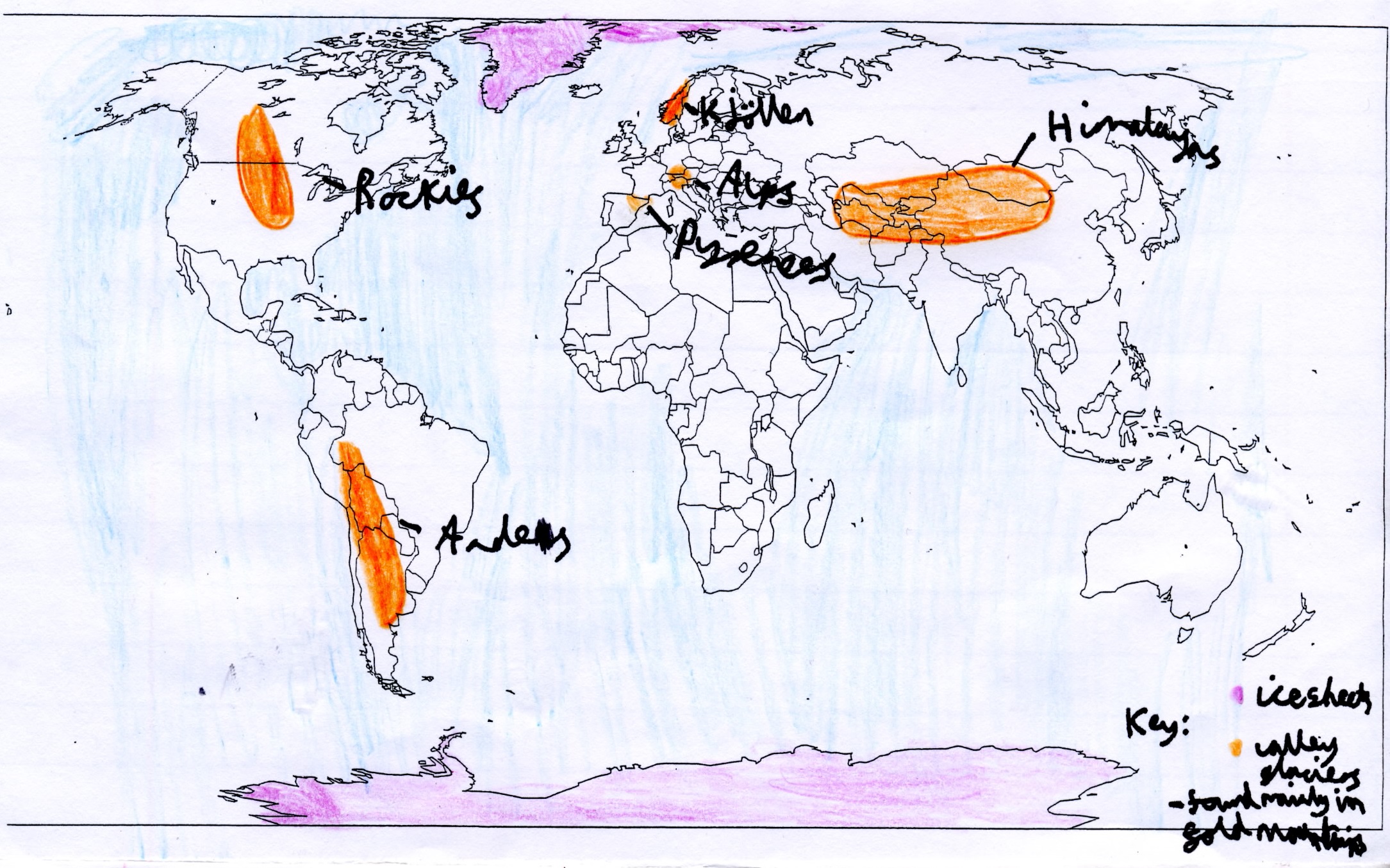
- Valley glaciers are found
in the Alps (Europe), the
Himalayas (Asia), the
Andes (South America)
and also in New Zealand;
glaciers are found in all
of Earth's continents and
in 47 countries.
- The Antarctica ice sheet covers
14 million km² and conatins
90% of Earth's fresh water. It is
in places several kilometres
thick.
- The Greenland ice
sheet covers an area of
1.7 million km² (80% of
Greenland!)
- A diagram to show the basic positions of the remaining large glaciated areas and ice sheets.
- Ice now covers only
10% of Earth on a
permanent basis. This
ice is found in 2 main
areas, the first being
areas of high latitude
(above 66° south or
north) and the second
being areas of high
altitude (high in the
mountains).
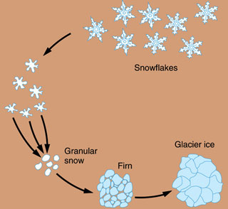
- What is ice?
- A diagram showing how snowflakes turn into
granular snow, then to firn, and then finally,
glacial ice.
- Many people think of ice as frozen water, but in
glaciation, that is incorrect. In glaciation, ice is
supercompressed snow. The ice is formed by the
following process:
- When snow falls to the ground, there are pockets of air
between the crystals. Over time, as more snow falls every
year, the crystals become compressed under the weight of
the new snow and the crystals stick together to form a form
of granulated snow which is stuck together; this is called
firn. Once all air has been completely squeezed out of the
firn and there are no more air spaces left, this is ice.
- A diagram showing how snowflakes turn into
granular snow, then to firn, and then finally,
glacial ice.
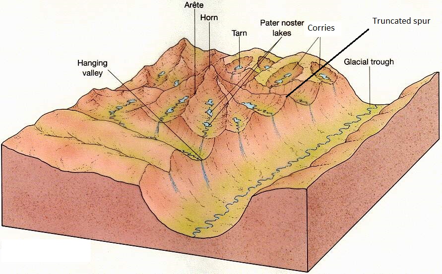
- Features of glacial erosion
- A diagram to show features of glacial erosion. A Pater noster lake is one of a
series of glacial lakes connected by a single stream or a braided stream system.
- Corries/Cwms/Cirques
- Snow accumulates in a nivation hollow. As more snow falls, gradually
the snow becomes compressed and the air is squeezed out to become
firn. Over thousands of years the firn becomes a glacier. Erosion and
weathering by abrasion, plucking and freeze-thaw action gradually
make the hollow bigger. Gravity can cause the ice trapped in the corrie
to move. This circular motion is known as rotational slip and can cause
the ice to pull away from the backwall creating a crevasse or
bergschrund. Plucked debris from the backwall causes further erosion
through abrasion which deepens the corrie. Some of this debris is
deposited at the edge of the corrie, building up the lip. These processes
create a characteristic rounded, armchair shaped hollow with a steep
back wall. When ice in a corrie melts, a circular lake is often formed at
the bottom of the hollow. This is known as a tarn.
- Arêtes and Pyramidal Peaks
- An arête is a knife-edge ridge. It is formed when two neighbouring corries run back to back. As each glacier
erodes either side of the ridge, the edge becomes steeper and the ridge becomes narrower. A pyramidal peak
is formed where three or more corries and Arêtes meet. The glaciers have carved away at the top of a
mountain, creating a sharply pointed summit.
- Glacial troughs, hanging valleys and truncated spurs
- Glaciers cut distinctive U-shaped valleys or troughs
with a flat floor and steep sides. The glacier widens,
steepens, deepens and smoothes V-shaped river
valleys. Glaciers also have tributaries. As the main
glacier erodes deeper into the valley, the tributary is
left higher up the steep sides of the glacier. These
U-shaped valleys ending with a water fall at the
cliff-face are called hanging valleys. When a river
erodes the landscape, ridges of land form in its
upper course which jut into the river. These are
called interlocking spurs. A glacier cuts through
these ridges leaving behind truncated spurs.
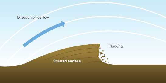
- Roche Moutonnes
- Roche moutonnées often have steep, jagged faces created by
plucking on the far (lee) side and a gradual incline which is
smoothed and polished by abrasion on the other (stoss) end. It
may have striations on it indicating the direction of glacier
movement.
- Roche moutonnées often have steep, jagged faces created by
plucking on the far (lee) side and a gradual incline which is
smoothed and polished by abrasion on the other (stoss) end. It
may have striations on it indicating the direction of glacier
movement.
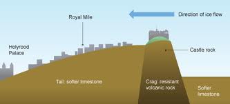
- Crag and Tail
- Crag and tails tend to be larger than a roche moutonnée. Crag and tail
is the opposite of the roche moutonnee as the ice hits the steep
resistant rock outcrop first. This protects the lee (far) side of the
obstacle from erosion. Edinburgh castle is built on crag and tail.
- Crag and tails tend to be larger than a roche moutonnée. Crag and tail
is the opposite of the roche moutonnee as the ice hits the steep
resistant rock outcrop first. This protects the lee (far) side of the
obstacle from erosion. Edinburgh castle is built on crag and tail.
- A diagram to show features of glacial erosion. A Pater noster lake is one of a
series of glacial lakes connected by a single stream or a braided stream system.
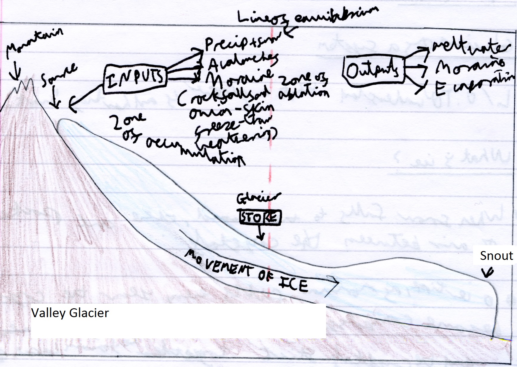
- Valley glaciers
- This diagram shows an average valley glacier
- A glacier is a system of inputs and outputs,
as well as stores and flows. The inputs mainly
occur in the zone of accumulaton in the form of
snow from precipitation and avalanches, as
well as moraine (sediment) from freeze-thaw
weathering The outputs mainly occur ikn the
zone of ablation, in the form of meltwater,
evaporation and moraine deposits.
- As with any system, the relationship
between the inputs and outputs alters the
behaviour of the glacier. We call the study
of these things the glacial budget. The
budget or balance of the glacier is usually
a net gain or a net loss over a 2-month
period.
- If:
- Accumulation > ablation, snout of the glacier will advance (net gain)
- Accumulation = ablation, the snout of the glacier will remain in a state of equilibrium
- Accumulation < ablation, the snout of the glacier will retreat (net loss)
- Accumulation > ablation, snout of the glacier will advance (net gain)
- If:
- As with any system, the relationship
between the inputs and outputs alters the
behaviour of the glacier. We call the study
of these things the glacial budget. The
budget or balance of the glacier is usually
a net gain or a net loss over a 2-month
period.
- This diagram shows an average valley glacier
- Glacial processes
- Abrasion
- Abrasion - rocks stuck in the ice grind away
the bedrock under the glacier
- Abrasion - rocks stuck in the ice grind away
the bedrock under the glacier
- Plucking
- Plucking - the base of glacier ice melts
due to pressure and friction. This allows
water to freeze into cracks in rocks, and
when the glacier moves it pulls out
chunks to leave a jagged surface. This
provides material for abrasion
- Plucking - the base of glacier ice melts
due to pressure and friction. This allows
water to freeze into cracks in rocks, and
when the glacier moves it pulls out
chunks to leave a jagged surface. This
provides material for abrasion
- Freeze-thaw weathering
- Freeze Thaw - water in cracks in the rock
freezes and expands forcing open the gap. When
the ice melts more water can get into the crack
and freeze again. After many cycles of freezing
and thawing lumps of rock are broken off the
surface.
- Freeze Thaw - water in cracks in the rock
freezes and expands forcing open the gap. When
the ice melts more water can get into the crack
and freeze again. After many cycles of freezing
and thawing lumps of rock are broken off the
surface.
- Abrasion
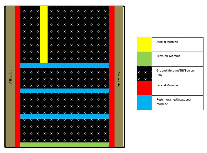
- Moraines
Media attachments
Want to create your own Mind Maps for free with GoConqr? Learn more.