4975626
river landscapes
- NATURAL RIVER FEATURES
- RIVER BASINS
- SOURCE: the start of the river
- TRIBUTARY: a small stream
that joins a larger stream/
river
- CONFLUENCE: where 2 rivers
meet
- MOUTH/ ESTUARY: where the
river meets the sea
- MOUTH/ ESTUARY: where the
river meets the sea
- CONFLUENCE: where 2 rivers
meet
- TRIBUTARY: a small stream
that joins a larger stream/
river
- DRAINAGE BASIN: the area
drained by a river and its
tributaries
- WATER SHED: the boundary
between 2 drainage basin,
generally hills
- WATER SHED: the boundary
between 2 drainage basin,
generally hills
- SOURCE: the start of the river
- CHARACTERISTICS OF A RIVER
AKA. THE RIVERS PROFILE
- RIVER FLOODING
- NATURAL CAUSES
- RAINFALL INTENSITY
- GEOLOGY
- SNOW MELT
- DRAINAGE BASIN
- STEEP SIDED VALLEYS/ LOTS
OF TRIBUTARIES MEANS
WATER ENTERS THE RIVER
QUICKER
- STEEP SIDED VALLEYS/ LOTS
OF TRIBUTARIES MEANS
WATER ENTERS THE RIVER
QUICKER
- WARMER TEMPERATURES
IN SPRING CAUSE THE
SNOW TO MELT,
CREATING MORE WATER
- DRAINAGE BASIN
- HARD ROCKS AKA.
GRANITE ARE
IMPERMEABLE, SO
WATER CAN'T
PERCOLATE FROM THE
SOIL BELOW
- SNOW MELT
- LOTS OF RAINFALL OVER A
SHORT PERIOD OF TIME =
NO SOIL INFILTRATION
- EXCESS WATER FLOWS TOWARDS THE RIVER AS SURFACE RUN OFF OR GROUND WATER
- WATER REACHES THE CHANNEL FASTER, FORCING THE RIVER LEVEL TO RISE ABOVE THE BANK, RESULTING IN FLOODING
- EXCESS WATER FLOWS TOWARDS THE RIVER AS SURFACE RUN OFF OR GROUND WATER
- GEOLOGY
- RAINFALL INTENSITY
- HUMAN CAUSES
- DEFORESTATION
- CLIMATE CHANGE
- URBANISATION
- RAIN IS FORCED TO QUICKLY
FLOW INTO SEWERS AND
DRAINS RATHER THAN
IMPERMEABLE TARMAC
- RAIN IS FORCED TO QUICKLY
FLOW INTO SEWERS AND
DRAINS RATHER THAN
IMPERMEABLE TARMAC
- MELTING GLACIERS AND
ICE SHEETS RESULT IN
MORE WATER
- URBANISATION
- LESS WATER IS
INTERCEPTED BY PLANTS
AND TREES, INTENSIVE
FARMING LEADS TO MORE
SURFACE RUN OFF
- EXCESS WATER FLOWS TOWARDS THE RIVER AS SURFACE RUN OFF OR GROUND WATER
- WATER REACHES THE CHANNEL FASTER FORCING HE RIVER LEVEL TO RISE ABOVE THE BANK, RESULTING IN FLOODING
- EXCESS WATER FLOWS TOWARDS THE RIVER AS SURFACE RUN OFF OR GROUND WATER
- CLIMATE CHANGE
- DEFORESTATION
- REDUCING THE IMPACTS
- PLANNING
- AREAS AT RISK ARE
USED FOR PARK
LAND RATHER THAN
HOUSING, TO
REDUCE THE IMPACT
OF FLOODING: this is
called LAND USE
ZONING.
- AREAS AT RISK ARE
USED FOR PARK
LAND RATHER THAN
HOUSING, TO
REDUCE THE IMPACT
OF FLOODING: this is
called LAND USE
ZONING.
- PREVENTION
- THE EA OFFERS ADVICE ON
HOW TO REDUCE FLOOD
DAMAGE , aka. use ceramic
tiles not carpet, raise electrics
up the walls, use synthetic
materials for windows and
doors, install heating systems
on upper floors.
- eg. in LIC's homes are
built on stilts to
prevent flood
damage.
- eg. in LIC's homes are
built on stilts to
prevent flood
damage.
- THE EA OFFERS ADVICE ON
HOW TO REDUCE FLOOD
DAMAGE , aka. use ceramic
tiles not carpet, raise electrics
up the walls, use synthetic
materials for windows and
doors, install heating systems
on upper floors.
- EDUCATION
- THE EA KEEPS PEOPLE
UP TO DATE ON
FLOODING BY:
RELEASING LEAFLETS,
ADVERTISING, POSTING
INFORMATION AND
FLOOD WARNINGS
ONLINE, PROVIDING
PHONE HELPLINES AND
ORGANISING FLOOD
DRILLS
- flood drills are common in
schools along the missouri
river (nebraska) and green
river (washington) in the
USA
- flood drills are common in
schools along the missouri
river (nebraska) and green
river (washington) in the
USA
- THE EA KEEPS PEOPLE
UP TO DATE ON
FLOODING BY:
RELEASING LEAFLETS,
ADVERTISING, POSTING
INFORMATION AND
FLOOD WARNINGS
ONLINE, PROVIDING
PHONE HELPLINES AND
ORGANISING FLOOD
DRILLS
- PREDICTION
- THE EA AND FEMA
MONITOR RIVERS.
THEY USE THIS INFO
TO: help forecast
potential floods and
give advanced/ early
warnings of flooding
- after the Boscastle
flood in 2004, the EA
built new overflow
channels to carry
excess water.
- after the Boscastle
flood in 2004, the EA
built new overflow
channels to carry
excess water.
- THE EA AND FEMA
MONITOR RIVERS.
THEY USE THIS INFO
TO: help forecast
potential floods and
give advanced/ early
warnings of flooding
- PLANNING
- NATURAL CAUSES
- STAGES OF A RIVER
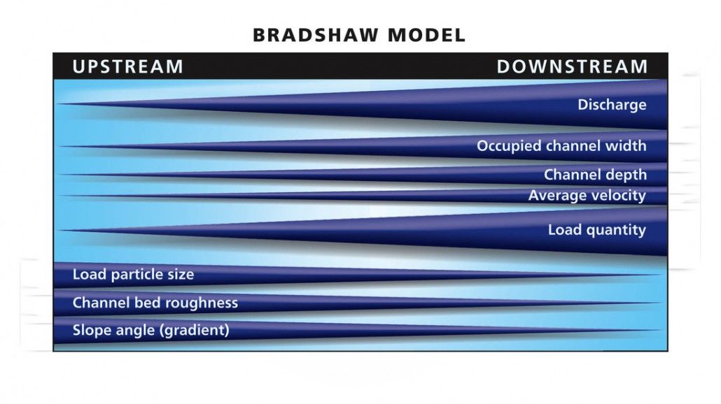
- THE UPPER COURSE:
STEEP SLOPES,
DOWNWARD EROSION,
SMALL DISCHARGE,
SLOW FLO, SHALLOW,
NARROW, STEEP V
SHAPED VALLEYS
- THE MIDDLE COURSE:
LARGE RIVER, ERODING
LATERALLY, STARTING TO
MEANDER AND BEND, A
MUCH WIDER, FLATTER
VALLEY
- THE LOWER COURSE:
WIDE, DEEP, FAST
FLOWING RIVER,
CARRYING A LARGE
AMOUNT OF MATERIAL
(LOAD), THE BED LOAD IS
VERY SMALL, VALLEY IS
FLAT AND VERY WIDE,
MOSTLY FLOOD PLAIN.
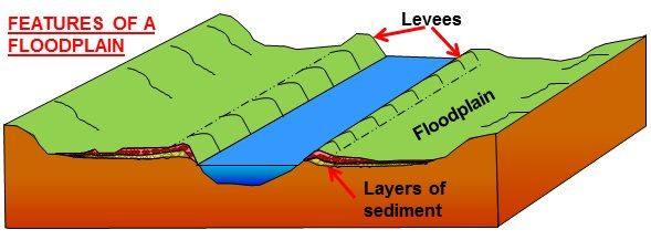
- FLOOD PLAINS
- in the lower course, the river
is nearing the sea and is
carrying lots of sediment
(alluvium)
- when the river floods,excess
water spills into the
surrounding area, depositing
sediment which forms the
flood plain.
- the flood plain is shaped by
lateral erosion and meanders as
they slowly migrate
downstream and deposit
material on their inner bends.
- the flood plain is shaped by
lateral erosion and meanders as
they slowly migrate
downstream and deposit
material on their inner bends.
- when the river floods,excess
water spills into the
surrounding area, depositing
sediment which forms the
flood plain.
- in the lower course, the river
is nearing the sea and is
carrying lots of sediment
(alluvium)
- LEVEES
- when flooding occurs the river
bursts its banks. the heavier
sediment is deposited close to the
banks due to the rivers decrease in
energy, resulting in natural
embankments.
- the smaller sediment, alluvium, is
deposited further from the river on
the flood plain, enriching the soil.
the levees build up over time.
- the smaller sediment, alluvium, is
deposited further from the river on
the flood plain, enriching the soil.
the levees build up over time.
- when flooding occurs the river
bursts its banks. the heavier
sediment is deposited close to the
banks due to the rivers decrease in
energy, resulting in natural
embankments.
- FLOOD PLAINS
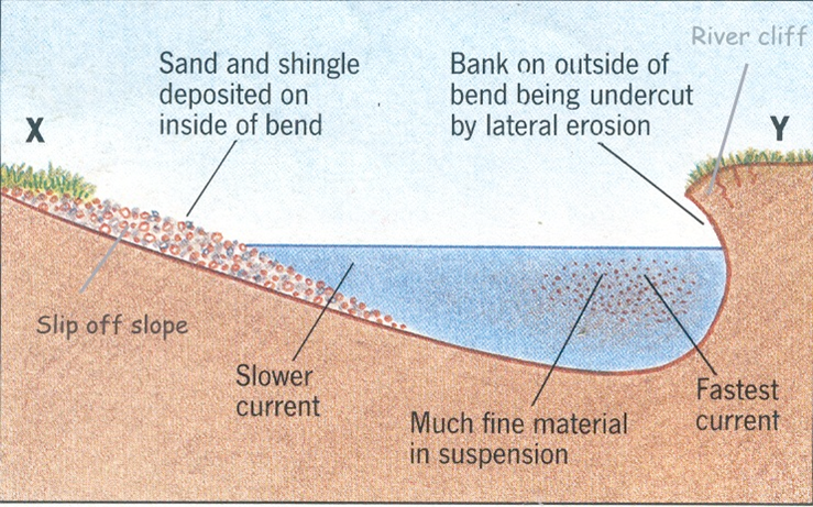
- MEANDERS
- (cross section)
- (cross section)
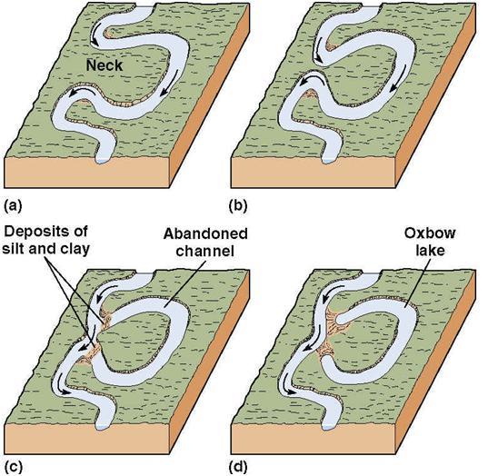
- OXBOW LAKE- FORMED BY LOOPING
MEANDERS WHICH ARE EVENTUALLY
BYPASSED BY THE RIVER. THE FINAL
OXBOW MAY FILL IN.
- THE LOWER COURSE:
WIDE, DEEP, FAST
FLOWING RIVER,
CARRYING A LARGE
AMOUNT OF MATERIAL
(LOAD), THE BED LOAD IS
VERY SMALL, VALLEY IS
FLAT AND VERY WIDE,
MOSTLY FLOOD PLAIN.
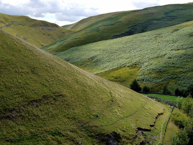
- INTERLOCKING SPURS
- AS THE STREAM ISN'T STRONG ENOUGH
TO ERODE RESISTANT ROCK, IT BENDS
AROUND THE SPURS, WHICH
EVENTUALLY INTERLOCK.
- AS THE STREAM ISN'T STRONG ENOUGH
TO ERODE RESISTANT ROCK, IT BENDS
AROUND THE SPURS, WHICH
EVENTUALLY INTERLOCK.
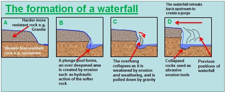
- WATERFALLS
- COMMON FEATURE IN UPPER COURSE,
FORM IN GORGES DUE TO VERTICAL
EROSION.
- COMMON FEATURE IN UPPER COURSE,
FORM IN GORGES DUE TO VERTICAL
EROSION.
- THE MIDDLE COURSE:
LARGE RIVER, ERODING
LATERALLY, STARTING TO
MEANDER AND BEND, A
MUCH WIDER, FLATTER
VALLEY
- THE UPPER COURSE:
STEEP SLOPES,
DOWNWARD EROSION,
SMALL DISCHARGE,
SLOW FLO, SHALLOW,
NARROW, STEEP V
SHAPED VALLEYS
- RIVER BASINS
- RIVER MANAGEMENT
- SOFT ENGINEERING
- AFFORESTATION: REPLANTING TREES IN THE DRAINAGE BASIN
- PROS: vegetation intercepts
ground water. woodlands provide
habitats and reduces visual
pollution
- CONS: land can't be
used for other things
- PROS: vegetation intercepts
ground water. woodlands provide
habitats and reduces visual
pollution
- LAND USE ZONING: PREVENTING HOUSING DEVELOPMENT ON FLOOD PLAINS
- PROS: residential projects can be built
built in low risk areas, and non vital
recreational spaces can be put in high risk
areas
- CONS: access for the public can be
made difficult, it can cause
planning problems in other areas
- PROS: residential projects can be built
built in low risk areas, and non vital
recreational spaces can be put in high risk
areas
- WASHLANDS: AREAS ON THE FLOODPLAIN WHICH ARE ALLOWED TO
FLOOD
- PROS: a relatively cheap way to solve the
issue of excess flood water, less visual
pollution
- CONS: use of the floodplain for
agriculture or residential areas is
restricted
- PROS: a relatively cheap way to solve the
issue of excess flood water, less visual
pollution
- AFFORESTATION: REPLANTING TREES IN THE DRAINAGE BASIN
- HARD ENGINEERING
- FLOOD RELIEF CHANNELING: extra channels to to carry surplus water
- PROS: water is channeled from
the river, preventing flooding
nearby
- CONS: visually unattractive, only
needed during periods of flooding,
expensive to build and maintain.
- PROS: water is channeled from
the river, preventing flooding
nearby
- EMBANKMENTS: LEVEES BUILT ON OR NEAR RIVER BANKS
- CONS: flood water can spill over
into protected areas. The levees
can burst under pressure, causing
widespread damage
- PROS: uses natural
materials, prevents
water moving into
areas at risk
- CONS: flood water can spill over
into protected areas. The levees
can burst under pressure, causing
widespread damage
- CHANNELISATION: deepening and widening the river
- PROS: allows water to
flow away more
quickly from areas at
risk from flooding
- CONS: visually
unattractive, increases
the flood risks to
settlements downstream
- PROS: allows water to
flow away more
quickly from areas at
risk from flooding
- DAMS: USED TO TRAP AND STORE WATER, CAN BE USED
TO CREATE HYDROELECTRICITY. (eg. the aswan dam)
- CONS: ugly, expensive to
build and maintain, can
reduce soil quality the valleys
below (think nile flooding)
- PROS: create large areas for
irrigation, fishing and water
sports
- CONS: ugly, expensive to
build and maintain, can
reduce soil quality the valleys
below (think nile flooding)
- FLOOD WALLS: USED TO PROTECT SETTLEMENTS FROM FLOODING
- PROS: very effective
- CONS: ugly and expensive
to build and maintain
- PROS: very effective
- STORAGE AREAS: EXCESS WATER CAN BE PUMPED FROM THE RIVER TO TEMPORARY STORAGE
AREAS IN ORDER TO REDUCE FLOODING eg. the mississippi diverts into lake pontchartrain
- PROS: effective, looks natural
- CONS: uses lots of space, can be expensive to pump
so much water
- PROS: effective, looks natural
- FLOOD RELIEF CHANNELING: extra channels to to carry surplus water
- SOFT ENGINEERING
- CASE STUDIES
- RIVER NENE, NORTHAMPTON 1998
- CAUSES
- TORRENTIAL RAINFALL AND
STORMS ON APRIL 8TH & 9TH, 3 X
THE NORMAL AMOUNT. THE
GROUND WAS SATURATED
COMPLETELY. THERE WAS NO
EFFECTIVE WARNING SYSTEM
- TORRENTIAL RAINFALL AND
STORMS ON APRIL 8TH & 9TH, 3 X
THE NORMAL AMOUNT. THE
GROUND WAS SATURATED
COMPLETELY. THERE WAS NO
EFFECTIVE WARNING SYSTEM
- IMPACTS
- SOCIAL: 2 PEOPLE DIED,
1500 WERE EVACUATED.
SEWAGE IN
NORTHHAMPTON CAUSED
SERIOUS HEALTH RISKS
- ECONOMIC: 2500 PROPERTIES
WERE AFFECTED, 5000 CARS WERE
WRITTEN OFF, £350, 000, 000
WORTH OF DAMAGE WAS CAUSED.
- SOCIAL: 2 PEOPLE DIED,
1500 WERE EVACUATED.
SEWAGE IN
NORTHHAMPTON CAUSED
SERIOUS HEALTH RISKS
- MANAGEMENT STRATEGIES
- HARD ENGINEERING
- FLOOD RETENTION RESEVOIR
AT BILLINGDON AQUADOME,
to hold extra water
- EARTHEN LEVEES ALONG THE RIVER
BANKS, replanted with trees to give more
structure and make it visually attractive
- 4M HIGH FLOOD WALLS NEAR
THE TRAIN STATION, in order to
prevent flooding on the tracks
- FLOOD RETENTION RESEVOIR
AT BILLINGDON AQUADOME,
to hold extra water
- SOFT ENGINEERING
- 4 WARNING
SIRENS AND A 2
HOUR WARNING
PERIOD were
installed by the
EA.
- THE UPTOWN
HOUSING ESTATE WAS
BUILT ABOVE THE
FLOODPLAIN, to
reduce damage to the
residential area
- A WASHLAND AT FAR COTTON AND
ST JAMES is being created. major
roads are being RAISED ON
EMBANKMENTS. SPECIAL FLOOD
GATES are being built, and 2 METRE
HIGH CONCRETE WALLS to protect
the roads.
- 4 WARNING
SIRENS AND A 2
HOUR WARNING
PERIOD were
installed by the
EA.
- HARD ENGINEERING
- CAUSES
- MISSISSIPPI, USA 2011
- CAUSES
- HUMAN: increased
development and
intensive farming on
impermeable floodplains
- PHYSICAL: heavy rain and
snow fall in kentucky, 4 x
the normal amount. high
proportion of tornadoes
- HUMAN: increased
development and
intensive farming on
impermeable floodplains
- IMPACTS
- SOCIAL: outbreaks of
tetanus and E. coli, loss of
life
- ECONOMIC: homes flooded,
cost of insurance, food and fuel
increases
- ENVIRONMENTAL: crops and
farmlands were destroyed,
fertilisers washed away, habitats
destroyed
- SOCIAL: outbreaks of
tetanus and E. coli, loss of
life
- MANAGEMENT STRATEGIES
- SOFT ENGINEERING
- SUBSIDISED INSURANCE
SCHEME to regulate land use
on the floodplain
- AGRICULTURAL LAND that
has been flooded is used
to store excess water
- RESTORATION OF WETLANDS
UPRIVER- these act as sponges
during heavy rain fall
- GOVERNMENT FUNDING FOR
FARMERS who convert land into
wildlife reserves and water
storage areas.
- SUBSIDISED INSURANCE
SCHEME to regulate land use
on the floodplain
- HARD ENGINEERING
- FLOODWAYS & CUT OFFS
divert water in times of flood
- LEVEES built in the 18th century
- RIVER STRAIGHTENING
- FLOODWAYS & CUT OFFS
divert water in times of flood
- SOFT ENGINEERING
- CAUSES
- RIVER NENE, NORTHAMPTON 1998
Media attachments
Want to create your own Mind Maps for free with GoConqr? Learn more.