
Notes
Chapter One: Canada- Making Connections Notes
Content of the notes (1)
Page 1
Geography Notes
What is Geography?
is there all the time: involves climate, geology, economics, biology, history and more
it is the study of the earth and all it's interactions
The Five Major Themes
location: absolute (i.e. latitude and longitude) and relative (i.e. drive left)
place: physical and cultural characteristics
regions: how can we classify and describe this area?
movement: of people, places, ideas and objects (the where and why behind the places people choose to live)
human interactions: how has human contact changed an area? (i.e. urbanization)
The Geographic Perspective
a way of looking at/understanding the world
latitude- north or south of the equator, up to 90 degrees (these are the horizontal lines running across the Earth)
Important Lines of Latitude- The Arctic Circle (66.5 degrees North); The Tropic of Cancer (23.5 degrees North); The Tropic of Capricorn (23.5 degrees South); The Antarctic Circle (66.5 degrees South)
longitude- east or west of the prime meridian, up to 180 degrees (these are the vertical lines running across the Earth)
Important Lines of Longitude- The Prime Meridian (0 degrees N/A; The International Date Line (180 degrees N/A)
Plotting Lines
latitude comes first (North [N] or South [S])
longitude comes second (East [E] or West [W])
elevation is the height above sea level- we measure it as 'X' meters above sea level
Regions Notes
Types of Regions
formal: official boundaries (cities and provinces)
physical: similarities in landscape or climate (i.e. the Rocky Mountains)
functional: connections through activity (the fur trade, communications)
perceptual: based on human emotions (mental map, i.e. "The Interior")
Globalization
technology now allows for communication on the global scale
opened the door to the transport of goods and ideas
Physical Regions
Canada has many regions with defining features
The Canadian Shield, for example, was once a volcanic mountain range (it is now flat with many lakes, and is half of Canada's landscape)
The Shield has very old, thin soil that is ideal for mining; this area was the first in Canada to be settled on by Europeans (the area has plenty of animals and is used mostly for farming and wineries)
The Appellation Region, consisting of The Maritime Provinces and South-Eastern USA, is high in minerals, and is layered rock, which is mostly coal
The Arctic/Tundra Region is mostly consisting of plains, mountains and lowlands
it is similar to the Appellation Region, expect it has few plants and animals (although it is rich in unharvest minerals)
Climate Notes
climate is the measuring of changes in temperature and precipitation over long periods of time
continental climate- the climate of a continent's interior region
precipitation climate- rain, snow, hail and fog
maritime climate- costal climate (mild temperatures and high precipitation)
many conditions can affect temperature, including (high latitude, altitude, distance from the sea, wind directions, and ocean currents)
precipitation can be a variety of things: snow, hail, fog, rain (precipitation differs between regions)
precipitation is associated with distance from the sea (and may be seasonal)
Climate Change
a change in global or regional patterns (use of fossil fuels has increased atmospheric carbon levels)
atmosphere has thinned because of pollution letting in more sun rays (the Greenhouse effect)
This is demonstrated by: warmer overall atmospheric temperatures (although some regions have cooled slightly), flooding, drought, and extreme summer heat, violent storms and other extreme weather events, effects of global water supply, animals migrating north to avoid warming climates, fish move up north, and certain Arctic species, such as polar bears, may disappear without anywhere more Northern to go
Natural Regions Notes
physical regions include resources, industry and climate
natural regions are biomes that differ based on vegetation and animal species
areas where the life cycles of animals and plants are closely linked
Subarctic
swampy areas covered in coniferous trees mixed w/ tundra vegetation
Animals include caribou, lemming, and snowy owls
Tundra
treeless landscape of permafrost; covered in shrubs, lichens, and mosses
Animals include polar bears, seals, walruses, muskox and arctic foxes
Open Woodland
scattered evergreen trees, shrubs and grasses
Animals include caribou, lynx, martens, beavers and bears
Coniferous Forest
a variety of trees, including evergreen, pine, spruce, and fir (the land isn't very fertile, however)
Animals include deer, moose, black bears, eagles and ducks
Coastal or Interior Forest
a wet climate, most trees are coniferous and able to grow to massive sizes
higher areas have subarctic/tundra features
Animals include cougars, mountain lions, sheep, bears, moose and a variety of birds
Mixed Forest
fertile land filled with softwood trees, including hemlock, cedar, maple, birch, oak and ash
Parkland
transition between dry prairies and coniferous region
they have long grasses, aspen and cottonwood
Grassland
short grasses, not enough moisture for trees
Animals include antelope, gophers, wild fowl, and the now extinct bison
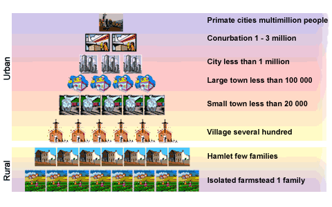
Settlement and Population Notes
Cultural landscape is how culture and attitudes influence how people view and use the land
Cree Natives viewed the land differently than the Europeans, for example.
The following influence cultural landscape:
Function of the land (is it for retail, trade, financial, transportation, government, recreational, cultural, manufacturing, or defence reasons?)
Familiar surroundings (if you grew up by the mountains, you may be more likely to settle somewhere you can see the mountains from) {examples of this include the British settlers, who looked for Urban centres, familiar to home, and the Eastern Europeans, who were used to the wide open spaces and farming lifestyle, who settled in the prairies}
The Metis and French people chose to settle in Manitoba, due to the French-style farming
Resources and industry are the biggest factors of settlement, however!
Boundaries
natural boundaries (mountains, rivers)
imaginary boundaries (between countries, cities, etc.)
Boundaries are all technically imaginary, but they influence the cultural landscape and have major significance in our lives
Information
- Description
- Horizons: Canada's Emerging Identity Unit One: Chapter One
- Created by
- haley_1434
- Views
- 13
- Rating