
Flashcards
Rivers
Flashcards do conjunto (96)
- 1Input: PrecipitationAll ways moisture comes out of the atmosphere
E.g Rain, Snow, Sleet or Hail - 2Storage: InterceptionPrecipitation which lands on vegetation or other man-made structure before reaching the soil.
- 3Storage: Surface StoragePrecipitation held in puddles, ponds and lakes.
- 4Storage: Vegetation StoragePrecipitation held by plants at any given time.
- 5Storage: Groundwater StoragePrecipitation stored in soil or in the rocks.
- 6Storage: Channel StoragePrecipitation held in a river or stream channel
- 7Flow: ThroughfallPrecipitation dripping from one leaf to the other
- 8Flow: Surface RunoffWhen the water is flowing over the land, either over the whole surface of in little channels.
- 9Flows: StemflowPrecipitation running down a plant stem or tree trunk.
- 10Flow: ThroughflowPrecipitation moving slowly downhill through the soil. It is faster through 'pipes' in the ground like cracks or animal burrows.
- 11Flow: InfiltrationWater soaking into the soil, influenced by soil type, structure and how much is already in the soil.
- 12Flow: PercolationWater seeping down through the soil into the water table
- 13Flow: Groundwater flowWater flowing slowly below the water table through permeable rock.
- 14Flow: BaseflowGroundwater flow that feeds into rivers
- 15Flow: InterflowWater flowing downhill through rock above the water table
- 16Flow: Channel FlowWater flowing in the river or stream itself.
- 17Output: EvaporationTurning precipitation from liquid to gas.
- 18Output: TranspirationEvaporation from plant leaves
- 19Output: EvapotranspirationBoth processes together
- 20Output: River dischargeWater leaving via the river
- 21What is a drainage basin?The area surrounding the river where the rain falling on the land flows into the river. Called the river catchment.
- 22What is the boundary of the drainage basin?The watershed - no water outside of this will fall into this drainage basin
- 23What system is a drainage basin?An open system with inputs and outputs
- 24What human factors affect the drainage basin?1) Dams
2) Urbanisation
3) Over extraction of water - 25What physical factors affect the drainage basin?1) Rock and soil
3) Vegetation cover
3) Weather and climate
4) Relief of the land - 26How does Hydraulic Action erode the river?Pressure of the water breaks rock particles away from the bed and banks.
- 27How does Abrasion erode the river?Eroded pieces of rock in the water scrape and rub against the bed and banks, removing material.
- 28How does attrition erode the river?eroded rocks smash into each other and break into smaller fragments and rounds off the edges of the jagged rock
- 29How does Cavitation erode the river?air bubbles in turbulent stretches of water implode causing shockwaves that break the rock.
- 30How does corrosion erode the river?The dissolving of rock by chemical processes.
- 31What is headward erosion?Erosion which increases the length of the river.
- 32What is vertical erosion?Deepens the river channel.
Occurs in upper stages of the river. - 33What is lateral erosion?Makes the river wider.
Occurs in middle and lower stages of river. - 34How does the process of solution carry material?Substances which can dissolve are carried in the water.
- 35How does the process of suspension carry material?very fine material is whipped up by turbulence and carried along in water
- 36How does the process of suspension carry material?Larger particles such as pebbles which are too heavy to be carried in suspension bounce along the river bed
- 37How does the process of traction carry material?Very large particles such as boulders are rolled along the river bed by the force of water.
- 38What are the characteristics of the : Upper Valley1) Vertical erosion with hydraulic action, abrasion and attrition
2) Lots of traction and saltation
3) Load size is large and angular
4) V-Shaped valley
5) Waterfall, gorges, rapids, interlocking spurs - 39What are the characteristics of the: Middle Reaches1) Deeper and wider channel
2) Vertical erosion less, more lateral erosion and deposition
3) Lots of suspension
4) Smaller and less angular load
5) Meanders, ox bow lakes, shallower valleys - 40What are the characteristics of the: Lower reaches1) Channel at its widest and deepest
2) more deposition than erosion
3) Fine material deposited
4) Large amount of load but size is small and rounded
5) floodplains and deltas - 41Channel Characteristics: Cross profileThe river's width
- This increases downstream - 42Channel Characteristics: Wetted PerimeterArea of water in contact with the river's bed and banks
- Increases downstream - 43Channel characteristics: Hydraulic RadiusCross Sectional Area / Wetted Perimeter
- This increases downstream - 44Channel Characteristics: RoughnessAngularity of rocks
- Decreases downstream - 45Channel Characteristics: EfficiencyMore efficient when more water in CSA
- 46Channel Characteristics VelocitySpeed of river water
- This increases downstream - 47Channel Characteristics: DiscahargeVolume of water moving past location in river
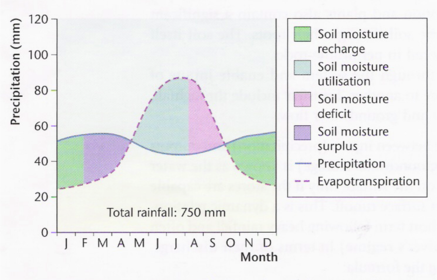
- This increases downstream - 48What is the water balance?shows the balance between inputs and outputs
- 49graph of the water cycle
- 50Formation of potholes:Small circular hollows in the river bed.
Formed by abrasion and turbulence in depressions/irregularities in river bed. - 51What are rapids?Steep sections of the river with turbulent flow. Erosion of softer bedrock making steeper gradients and more turbulent flow.
- 52Formation of waterfalls:1) Soft rock in river bed eroded quicker than harder rock causing a 'step' in bed
2) Water flowing over the step speeds up due to lack of friction when dropping over step. This increases the speed and gives greater erosional power causing greater erosion and undercutting of harder rock
3) One harder rock it may fall causing a plunge pool from the collapsed rock swirling by turbulence.
4) Over time, more undercutting causes more collapse, meaning it will retreat leaving a steep-sided gorge. - 53Formation of Gorges:Narrow valley between hills caused by the stream eroding the bed vertically.
- 54Formation of Meanders:1) Formed when altering pools and riffles develop in equal intervals along the river (5-6 times the width of the river).
2) As river is deeper in pools it has greater energy and more erosive power and energy is lost if riffles because of friction.
3) Spacing between riffles and pools causes uneven river flow and flow concentrates on one side of the river.
4) turbulence speeds up around one side of river so water twists and coils
5) cork-screw like currents called helicoidal flow is caused
6) Helicoidal flow causes deepening of the pools and deposition on the inside bend. This creates meanders - 55Formation of braided river:Occurs when rivers carry a vast amount of eroded sediment.
When the river loses velocity the river load is deposited in the river channel causing small, winding channels. - 56Formation of flood plain:When a river overflows its banks and floods the flat land either side increasing its wetted perimeter and reducing hydraulic radius.
- 57Formation of levees:When a flood of surrounding land occurs, river loses energy and deposits heaviest material closest to the river channel.
Raised embankments begin to build up creating a levee. - 58Formation of delta:When river reaches sea energy is absorbes by slower moving water, meaning material deposits its load and begins to build until the alluvium rises above sea level.
3 types: fan shaped, cuspate (arrow), bird foot. - 59What is rejuvenation?When the river base level falls due to either less sea water or ground level rising
- 60What are knickpoints?Area where there is a sharp change of gradient in the slope channel (waterfalls occur here)
- 61What are river terraces?Where vertical erosion occurs on a flood plain. River cuts downwards abandoning old flood plain and creating a new one.
- 62What are incised meanders?The same as river terraces but in meandering areas so the river cuts in a meandering shape
- 63What is magnitude frequency analysis?How often a certain significance will occur
e.g. one in a 100 year flood.
It is used to help predict an areas risk of flooding - 64LEDC Case Study: LocationBangladesh, Asia
- 65Date of flood? Population? GNP?1998
120 million
$200 - 66Physical causes of the flood?1) 1-2 Metres above sea level
2) 3 rivers peak flow at same time
3) Located on flood plain
4) monsoon season causes heavy rain - 67Human Causes of flooding?1) Climate change
2) Deforestation
3) Urbanisation
4) Building on flood plains - 68Primary effects of flooding?1) 23,000,000 homeless
2) Widespread starvation (1/4 children U5)
3) 660 000 Hectares crops destroyed
4) 130,000 cattle died - 69Secondary effects of floods?1) 400 factories forced to close
2) 11 000km road damaged
3) 1 000 schools destroyed - 70Short term response of the the flood?1) Medical care
2) WHO launched appeal for food
3) Water purification tablets
4) 1 mil tonnes of international food provided - 71Long term responses to the flood?1) Afforestation
2) 5000 Flood shelters
3) 7 new dams - 72MEDC Flooding Case Study: Location? Time? Population? History of flooding?1) Carlisle
2) 2005
3) 70,000
4) 3 major flood in 4 years - 73Physical causes of flooding?1) Rainfall
2) Low Gradient
3) Lack of vegetation - 74Human causes of flooding?1) Urbanisation
2) Lack of flood protection - 75Primary effects of floods?1) 3 died
2) 210 injured
3) Communications effected
4) 70 000 without power
5) 1 600 homes flooded - 76Secondary effects of floods1) Nearly 2000 homes and businesses flooded
2) 6000 homeless
3) 40,000 without power
4) Cost £100 million - 77Short term response of flood?1) News warnings
2) Emergency services - 78Long term response of flooding?1) Raise existing defences
2) Reservoirs and dams - 79Soft Engineering Scheme: Land use management (how it works)Planning restrictions prevent building or roads being built on flood plains.
Flood plain allocated to things like playing fields and parks. More water can infiltrate so less surface runoff. - 80Extra benefits?1) No new buildings or roads on the floodplain to be damaged so impact is reduced
2) Provides areas for recreational opportunities. - 81Disadvantages?1) Restricts development which is especially bad in areas where there is a shortage of housing
2) Cannot be used in already urbanised areas. - 82Soft Engineering Scheme: Wetland and River bank Conservation (How it Works)Wet lands store flood water and also slow it down. Conserving or reestablishing wetland gives natural protection from flooding. Planting trees and shrubs (known as riparian buffers) also increase interception and lag time therefore reducing discharge.
- 83Extra benefits?1) Vegetations protects the surface soil from erosion
2) The vegetation provides additional habitats for wildlife. - 84Disadvantages?1) Less land is available for farming
- 85Case Study: Soft EngineeringAbingdon, SE London
- 86History of flooding?Regular history of flooding (1500 properties in Abington have a 1% chance every year).
Intense storms in 2007 caused bad flash floods. River Thames and OCk burst their banks, flooding 660 properties. - 87Why were hard engineering options rejected?1) A diversion slipway would have been too expensive
2) Flood barriers in Abington would increase flood risk downstream
3) Flood protection is mostly done through soft engineering defences. - 88Defences put up?1) Gravel Soakways on A34
2) Low value land allows to flood e.g. Tillsley Park sports grounds.
3) Planning restrictions on new housing developments
4) Tesco forced to revise recent extension plans
4) 24 hour flood line put in place.
5) Detailed online advice about reducing flood damage
6) Improvements made to riparian buffers along smaller rivers. - 89Disadvantages?1) Difficult to measure success of flood defences.
2) Several flood warnings were still issued by Environmental agency in early 2008. - 90Advantages?1) 2008 Floods less damage than in previous years with minimal cost (little disruption to community, no lives lost and few injured).
2) Thames flood plain did get flooded but little disruption as it is largely clear of development. - 91Case Study: Hard EngineeringThree Gorges Dam, Yangtze River, China
- 92History of flooding?Seasonal flooding (monsoon season).
Fiver major floods happened over the last century.
1954 flood killed 33 000 people and over 18 million had to be moved. - 93What is the Three Gorges Dam?101 m high dam constructed in 1994 to help catch flood water in a reservoir and release it slowly over time to prevent flooding.
It can store 22 km3 of flood water and provide hydroelectric power with its 26 turbines. - 94Positive effects:1) Reduced major flooding from once every ten years to once every 100.
2) Dam turbines produce a lot of electricity (3% of China's supply)
3) River shipping has increased as bigger ships can now travel up the river due to the deep reservoir. - 95Negative effects:1) Due to the water level rising up to 2 million people had to be relocated (13 cities and 1350 villages
2) Flooded farmland, 650 factories and 1300 cultural and historical sites (e.g. Temple of Zhang Fei).
3) Sediment carried by the river is trapped by the dam which may lead to failure and catastrophic flooding. - 96Did the dam destroy habitats?1) Endangered Siberian crane spends winter in wetlands below dam but this is anticipated to be be affected.
2) Fewer than 100 Baiji dolphins left and the dam reduces there food supply
Informações
- Descrição
- A-Level Geography (AS ) FlashCards sobre Rivers, criado por Ella Foster em 01-11-2016.
- Criado por
- Ella Foster
- Visualizações
- 1
- Avaliação