9013514
Descrição

FlashCards por Natalia Cliff, atualizado more than 1 year ago
|
|
Criado por Natalia Cliff
quase 7 anos atrás
|
|
| Questão | Responda |
| What is erosion? | the sculpting of a landscape, for example by rivers, involving removal of material |
| What are the types of erosion? | -Hydraulic action -Abrasion -Attrition -Solution |
| What is hydraulic action? | The power of the volume of water moving in the river (the sheer force of the water) |
| What is abrasion? | Abrasion occurs when the larger load of the river hits the bed and banks, causing bits to break off |
| What is attrition? | Attrition is the knocking together of stones and boulders in the river, making them gradually smaller and smoother |
| What is solution? | Solution is the dissolving of rocks and minerals by water |
| What is transportation? | Transportation is the carrying of sediment downstream from the point where it has been eroded to where it is deposited |
| What are the kinds of transportation? | -Traction -Saltation -Suspension -Solution |
| What is traction? | Traction is the rolling of the largest rocks and boulders along the river bed |
| What is saltation? | Saltation is the bouncing movement of small stones and grains of sand along the river bed |
| What is suspension? | small material being carried by the water that neither floats nor sinks |
| What is solution? | Dissolved rocks and minerals being carried by the water |
| What is deposition? | Deposition is the dumping of sediment that has been transported by the river The river deposits it's load when it loses energy |
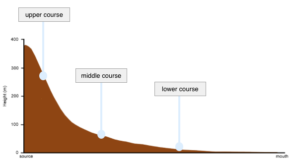
| Draw a river's long profile |
Image:
Long Profile (image/png)
|
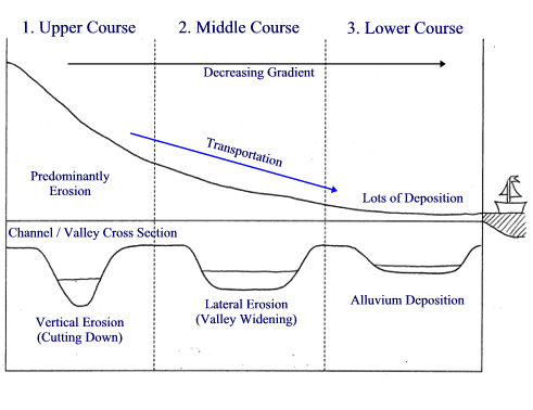
| Draw the changes of a river's cross profile |
Image:
Cross Profile (image/gif)
|
| What are the characteristics of a river in it's upper course? | -Shallow, narrow channel -Vertical erosion -Hydraulic action, abrasion, attrition -Some traction and saltation at high flow -Deposition of large material -Large load |
| What are the characteristics of a river in it's middle course? | -Wider, deeper channel -Some vertical erosion, lateral erosion is more important -Hydraulic action less important -Mainly Suspension, some traction and saltation still present -Deposition more obvious -Load size reduced |
| What are the characteristics of a river in it's lower course? | -Widest, deepest channel -Little erosion, only a little lateral -Erosion a lot less important -Suspension dominant -Deposition of fine material -Large amount of very small load |
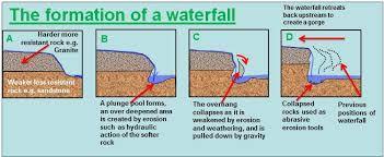
| Formation of a Waterfall | -Water flows over a band of hard over a band of soft rock -Soft rock erodes (hydraulic action and abrasion) to form a plunge pool -This leaves an overhang -Overhand collapses due to lack of support and gravity -Process repeats itself -Waterfall retreats upstream |
| Diagrams for formation of a waterfall | |
| Formation of a gorge | -All of the steps for formation of a waterfall -The retreating waterfall cuts out a steep sided valley called a gorge |
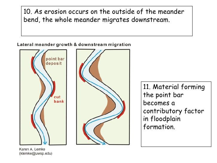
| Formation of a meander | -River erodes more on one side and undercuts the bank -Deposition occurs on the other side with a slip off slope -Erosion the inside of the bend, deposition on the outside -Over time meander bends more as it migrates downstream |
| Diagram for formation of a meander |
Image:
Meader (image/jpeg)
|
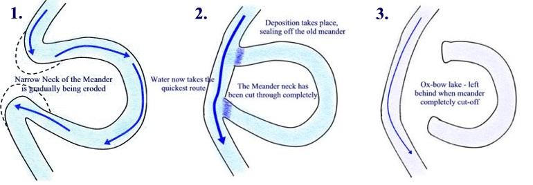
| Formation of an ox-bow lake | -All of the steps for formation of a meander -As the meander migrates downstream, erosion causes the neck to tighten -Eventually the river breaks through -Deposition cuts off the meander leaving behind an ox bow lake |
| Diagram for formation of an ox bow lake |
Image:
Oxbow Lake (image/gif)
|
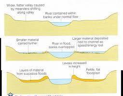
| Formation of a floodplain and levees | -River floods in the lower course -Once it's flooded, loses all of it's energy so deposits fine load -Heavier load deposited first, creating heightened banks called levees -Smaller load fills holes and gaps in the ground creating a flat floodplain next to the river |
| Diagram for formation of floodplain and levees |
Image:
Floodplain (image/jpeg)
|
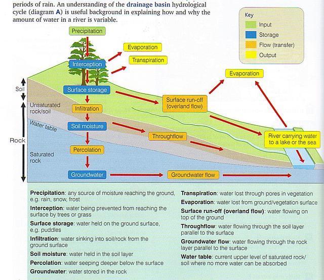
| How does rainwater travel through/on the ground? |
Image:
Rainwater (image/jpeg)
|
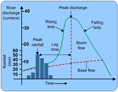
| Describe and label a storm hydrograph |
Image:
Storm Hydrograph (image/gif)
|
| What factors affect river discharge? Why do rivers flood? | -Deforestation (less interception) -Urbanisation (more impermeable surfaces, so more surface run off) -Building construction -Amount of rainfall -Temperature (evaporation) -Relief (slope) of the land -Rock type (impermeable rocks mean more surface run off) -Previous weather (if soil saturated then more surface run off) -prolonged rain, heavy rain, snowmelt |
| Are floods getting more frequent? | YES: -More floods reported -Could be caused by changes in weather NO: -People just building more on floodplains so floods affect more people and seem worse |
| Cockermouth flooding of 2009 What were the causes? What happened? | -Wet autumn so ground saturated -Torrential rain, most rain ever to fall in 24 hours -Steep relief in hilly lake district -2.5 m of water cascaded down the main road |
| Cockermouth flooding of 2009 What were the social effects? | -one policeman died -1300 people affected by the flood -Homes without power or water -Local schools shut down -Workington (northern part) cut off |
| Cockermouth flooding of 2009 What were the economic effects? | -Insurance companies expected to pay over £100 000 000 -Land inundated (large rocks) -Livestock killed -Walls, farm houses and machinery destroyed -Shop stock destroyed -1 m mud and silt to be cleared |
| Cockermouth flooding of 2009 What were the short term responses? | -200 people airlifted out -Some rescued by boat -Evacuated people put in a temporary shelter -Flooded buildings assessed -small businesses given temporary trading accommodation |
| Cockermouth flooding of 2009 What were the long term responses? | -1800 bridges inspected -Residents given alternative accommodation for months -Several roads in the town square needed were completely resurfaced |
| Bangladesh flooding of 2004 What were the causes? | -Bangladesh is low-lying and on the Ganges, Brahmaputra and Meghna delta -Deforestation in Nepal meant more water in rivers -Snow melt from the Himalayas -Heavy monsoon rain -Heaviest rain in 50 years 35 cm on one day -By July 60% of country flooded |
| Bangladesh flooding of 2004 What were the effects? | -750 deaths -30 mill homeless out of 140 mill -100 000 people in Dhaka alone suffering from diarrhea as floodwater spread sewage -roads, railways and bridges destroyed, hampering aid -School and Hospital damage was $7 billion -Rice (main food crop) washed away with vegetables and cash crop like sugar cane -30% increase price of rice |
| Bangladesh flooding 2004 What were the short term responses? | -food, medicine and clothing distributed -WaterAid distributed water purification tablets -Local communities rebuilt homes |
| Bangladesh flooding 2004 What were the long term responses? | -UN appealed for $74 million but only received 20% -Embankments built (but don't really work) -Flood warning system with flood shelters (areas of raised land) |
| What is hard engineering? | Building artificial structures aimed at controlling natural processes |
| What kind of hard engineering can be used for rivers? | -Dams -Reservoirs -Straightening meanders (deals with flooding) |
| Three Gorges Dam China Where is it? | -China... -Yichang on the Yangtze |
| Three Gorges Dam China What are the benefits? | -Floods reduced from 1 in 10 year to 1 in 100 year event -Helps 15 mill people living in high flood risk areas -Protects 25 000 ha of farmland -Helps flood control, navigation and power generation |
| Three Gorges Dam China What are the issues? | -Yangtze used to carry 500 mill tonnes silt every year, half of that now behind the dam reducing reservoir capacity and starving farmland downstream -Chongqing pumps 1 billion tonnes of sewage into the river every year -Factories put in toxic substances -1.4 million people forcibly removed but never given compensation, $30 mill set aside for this taken by corrupt officials |
| What is soft engineering? | Tries to work with the natural river system in a sustainable way |
| Examples of soft engineering | -Avoid building on flood plains -Flood plain zoning -Do nothing -Flood warning -Planting trees |
| Brisbane Floodplain zoning | -Avoid areas near river -Then pastures for grazing -Playing fields -Roads and car parks -Industry -Finally housing This diminishes negative affects of flooding |
| Why does is the UK using more water? | -More affluent lifestyle -Growing population |
| How can this be dealt with? | -Water transfer from areas of water surplus to areas of water deficit -Conservation tactics |
| Water are water conservation tactics? | -Houses designed with better water efficiency -Devices in toilet cisterns mean less water is used -Rainwater collected -Bath water recycled to flush toilets -Shower rather than bath |
| Keilder Water Reservoir, Northumberland Where is it? How many people does it supply? What's the daily supply? | -Northumberland (northwest England, a high precipitation zone) -supplies 2.5 mill people -daily supply of 729 million litres |
| Keilder Water Reservoir, Northumberland What are the advantages? | -hydroelectric power of 6 MW of power -Flood prevention -£6 mill raised through tourism -Several sites of SSSI's that protect red squirrels for instance |
| Keilder Water Reservoir, Northumberland What are the disadvantages? | -holds back necessary sediment -58 families displaced from their homes -2700 ha of habitat lost -clear water erosion further downstream |
| Where has flooding occurred in the UK in the past 20 years | -1998 Easter floods (central England) -2000 Millennium floods (all of UK) -2007 floods in Gloucestershire -2012 floods all across UK |
Quer criar seus próprios Flashcards gratuitos com GoConqr? Saiba mais.