
Notas
Tectonic hazards
Conteúdo das notas (6)
Página 1
Distribution of earthquakes and volcanoes
Why is there a pattern in Earthquakes?
Earthquakes are a sudden and violent shaking of the ground
They are most commonly caused by sudden movement of rocks in the earths crust
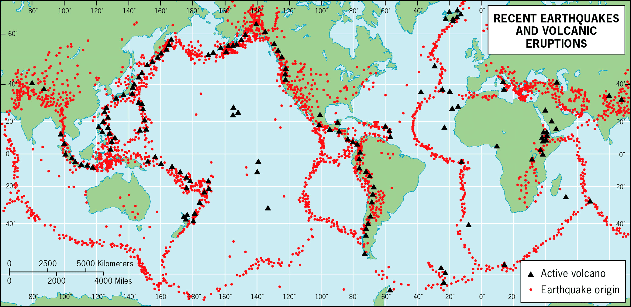
They occur mainly at tectonic plate margins, here the plates are moving which builds up pressure that is released
COMPARING THE DISTRIBUTION OF VOLCANOES
Along the western coast of North and South Amercia there are lots of earthquakes and it is also where there is a plate margin
The occurence of Earthquakes along the Pacific Ocean follows the plate margins
Some Earthquakes do not occur at plate margins- this may be caused by human activity such as underground mining or oil extraction
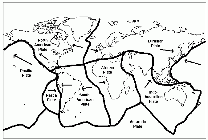
TECTONIC PLATES
The earth's crust is split into a number of plates about 100km thick
There are two types of crusts- dense, thin oceanic crusts and less dense, thick continental crusts
Plates move in relation to each other due to convection currents from deep within the Earth
A denser oceanic plate may subduct (sink) beneath a less dense continental plate
Gravity pulls the oceanic plate into the mantle, dragging the plate away from the constructive margin
Tectonic activity at plate margins causes earthquakes and volcanoes
WHERE DO VOLCANOES HAPPEN?
Volcanoes form over a long period of time
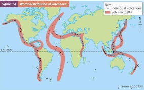
Volcanoes occur along long belths that follow the plate margins- Around the edge of the Pacific Ocean- The Pacific ring of fire
There is also a belt of volcanoes through the middle of the Atlantic Ocean- The Mid- Atlantic Ridge
WHY IS THERE A PATTERN OF VOLCANOES?
Volcanoes are fed by hot molten roch deep within the Earth
The magma rises to the surface at constructive and destructive plate margins
Volcanoes also form at hot spots, where the crust is thin and magma can break through the surface
Hawaiin Islands in the Pacific Ocean are an example of a hot spot
Página 2
Physical Processes at Plate Margins
CONSTRUCTIVE MARGIN
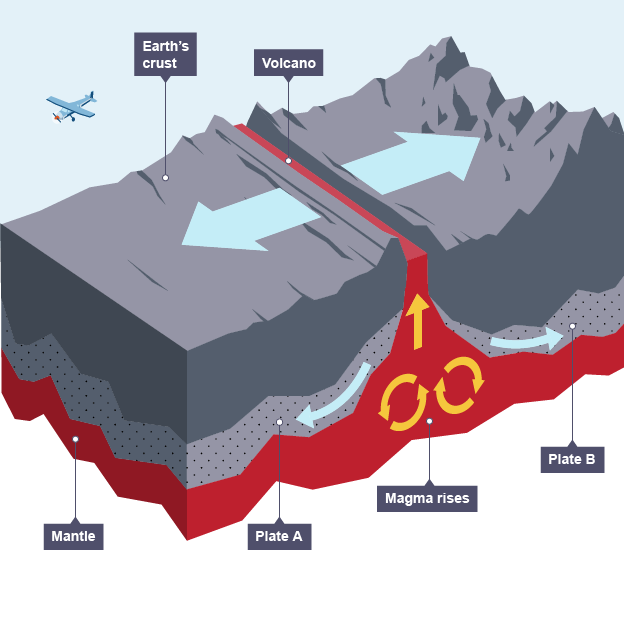
At a constructive plate margin the two plates move apart
When the plate move apart magma forces its way to the surface
As it breaks the crust it causes mild earthquakes
The magma is very hot and fluid allowing the lava to flow a long way before cooling
Constructive plates often result in broad flat sheild volcanoes- e.g. Mid-Atlantic Ridge
DESTRUCTIVE MARGIN
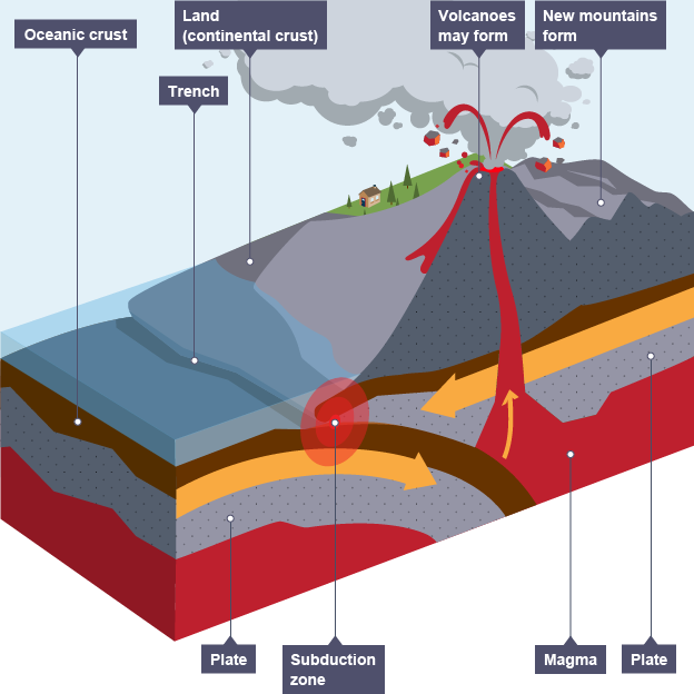
At a destructive plate margin the two plates move towards each other
Continental plates
Where two continental plates meet there is no sunduction so no magma to form volcanoes
The crust crumbles and lifts to form mountains- e.g. Himilayas
Powerful earthquakes can be triggered
Oceanic plate and a continental plate
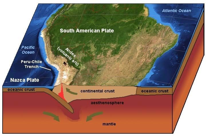
An example of a destructive margin is the West Coast of South America
Here the dense oceanic plate is subducted beneath the less dense continental plate
Friction causes strong earthquakes
The sinking oceaninc plate creates sticky, gas-rich magma
This results in steep-sided composite volcanoes which erupt violently
CONSERVATIVE MARGIN (transform margin)
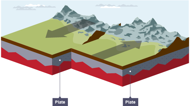
At a conservative plate margin the two plates move past each other at different rates
Friction between the two plates build stresses and trgger earthquakes when they slip
There are no volcanoes because there is no magma
Página 3
The effects of earthquakes (case study- Chile and Nepal Earthquakes)
Primary effects (caused by the ground shaking) destroy buildings and infrastructure, and kill and injure
Secondary effects (resulting from the shaking) include fires and landslides
Responses include emergency care, support and long-term reconstruction

Wealth (GPD- Gross domestic product) and quality of life (HDI- human development index) indicators
GPD 38th out of 193
HDI 41st out of 187 countries
Cause of Earthquake
Nazca plate subducted beneath the South American Plate
Just off the coast Central Chile
Size
Magnitude: 8.8
Shallow focus (35km)
Primary effects
500 killed
12 000 injured
800 000 people affected
Significant destruction of buildings and infrastucture
Power, water and communications cut
$30 billion (US) damages
Secondary effects
Communities cut off by landslides
Coastal towns devastated by tsunami
Chemical plant fire near Santiago forced evacuations

Wealth (GPD- Gross domestic product) and quality of life (HDI- human development index) indicators
GPD 109th out of 193 countries
HDI 145th out of 187 countries
Cause of Earthquake
Indo-Australian Plate colliding with the Eurasian plate
Size
Magnitude: 7.9
Very shallow focus (15km)
Primary effects
9000 killed
20 000 injured
8 000 000 people affected
Widespread destruction of buildings and infrastructure
Power, water, sanitation and communication cut
$5 billion (US) damage
Secondary effects
Communities cut off by landslides and avalanches
Avalanches on Mount Everest killed at least 19 people
Flooding caused by (landslide) blocked rivers
Página 4
Responses to Earthquakes
Immediate response: search and rescue and keeping survivors alive by providing medical care, food, water and shelter
Long-term response: re-building and reconstruction, with the aim of returning people's lives back to normal and reducing risk
COMPARING RESULTS
chile
Chile Earthquake's are quite common
Local ommunities were prepared and knew how to respond quickly and effectively
Chile also had the money to support people and to rebuit
Nepal
Nepal Earthquake's are not uncommon
Scientists identified a pattern of large earthquakes in this region around every 80 years
Depsite the warnings and new building regulations, little had been done to prepare the city and people for when an earthquake struck
Immediate responses
Emergency services acted very quickly. International help supplied field hospital, satellite phones and floating bridges
Temporary repairs were made to the important Route 5 north-south highway within 24 hours, enabling aid to be transported from Santiago to affected areas
Power and water restored to 90% of homes within 10 days
A national appeal raised US$60 million- eniugh to build 30 000 small emergency shelters
Long-term responses
A month after the Earthquake the Chile government launched a housing reconstruction plan to help nearly 200 000 households affected by the earthquake
Chile's strong economy, based on copper exports, could be rebuilt without the need for much foreign aid
The president announced it could take 4 years for Chile to recover fully from the damage to buildings and ports
Immediate responses
search and rescue teams, water and medical support arrived quickly from countries such as the UK, India and China
Helicopters resued many people caught in avalanches on Mount Everest and delivered supplies to villages cut off by landlides
Half a million tents needed to provide shelter to the homeless
Financial aid pledged to support overcrowded main hospitals
300 000 people migrated from Kathmandu to seek shelter and support with family and friends
Social media widely used in search and rescue operations and satellites mapped damaged areas
Long-term responses
Roads repaired and landlides cleared. Lakes, formed by landslides damming river valleys, need to be emptied to avoid flooding
Thousands of homeless people to be re-housed, and damaged homes repaired. Over 7000 schools to be re-built or repaired
Stricter cotrols on building codes
In June 2015 Nepal hosted an international conference to discuss reconstruction and seek technical and financial support from other countries
Tourism, a major source of income, to be boosted- by July 2015 some heritage sites re-opened and tourists were starting to return
Repairs to Everest base camp and trekking routes- by August 2015 new routes had been established and the mountain re-opened to climbers
In late 2015 a blockade at the Indian border badly affected the supplies of fuels, medicines and contrcution materials
Página 5
Living With The Risk From Tectonic Hazards
The majority of tectonic hazards occur at plate margins some of which run through densely populated regions such as Japan, parts of China and southern Europe
WHY PEOPLE LIVE AT RISK FROM TECTONIC HAZARDS
Poor people have no choice- money, food and family are seen as more important
Earthquakes and volcanic eruptions are rare, so not seen as a great threat
Earthquake-resistant building designs reduce risk
Effective monitoring of volcanoes and tsunami waves allow evacuation warnings to be given
Plate margins often concide with favourable areas for sttlement and trade, e.g. flat, coastal areas
some people have no experience or knowledge of the risks
Volcanoes can bring benefits auch as fertile soils, rich mineral desposits and hot water
Earthquakes fault lines can allow water to reach surface area- important in arid regions
Página 6
Reducing The Risk From Tectonic Hazards
MONITORING
Volcanoes
All active volcanoes are modified using hi-tech scientific equipment including
Remote sensing- satelites detect heat increases
Seismicity- seismographs record microquakes
Groud deformation- laser beams measure changes in the shape of the ground
Earthquakes
Earthquakes normally occur without warning. Lots of different events can happen before an earthquake strikes, but they are never certain warnings. The events that could happen are:
microquakes before the main tremor
Buldging of the ground
raised groundwater levels
PROTECTION
Volcanoes
Not much can be done to protect property
Earth embankments and explosives have successfully diverted lava flows
Earthquakes
Earthquake drills help keep poeple alert and prepared
Earthquake-resistant construction is the best way to reduce the risk
PREDICTION
Volcanoes
Monitoring now allows for accurate prediction and effective evacuations
Earthquakes
Accurate predictions are impossible due to a lack of clear warning signs
Historical records can help to determine probability and so help in planning for them
PLANNING
Volcanoes
Risks assesment and hazard mapping to identify areas to practise evacuation or restrict building
Earthquakes
Risk assesment and hazard mapping to identify areas to protect buildings and infrastructure
Informações
- Descrição
- GCSE Geography Notas sobre Tectonic hazards, criado por Gabriella Weisser em 12-05-2021.
- Criado por
- Gabriella Weisser
- Visualizações
- 1
- Avaliação