9616689
Descrição
Quiz por FLTLT Rachelle Warner, atualizado more than 1 year ago
|
|
Criado por FLTLT Rachelle Warner
quase 7 anos atrás
|
|
Questão 1
Questão
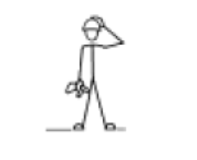
The field signal indicated by placing an open palm on top of your head and moving it up and down means what?
Responda
-
Obstacle
-
House or hut
-
Increase speed
-
Join me/Come to me
Questão 2
Questão
How would a section leader indicate 'Go Back' to his/her cadets?
Responda
-
By making a circular movement with their hand with one finger pointing upwards
-
By clenching their fist
-
By forming an inverted 'V' over their head with their arms
-
By making a circular movement with their hand with one finger pointing downwards
Questão 3
Questão
Extended line formations are used:
Responda
-
To search riverbanks
-
When efficient communication is required between personnel
-
To search through dense vegetation
-
When a wide frontal coverage is required
Questão 4
Questão
During a search utilizing the extended line section formation, the Section Commander is located
Responda
-
On the left directing the search
-
In the middle to co-ordinate the searchers
-
On the right co-ordinating the sections by runners
-
Leaving the search to the individual searchers after a briefing on the task
Questão 5
Questão
The most suitable area, from the below options, for setting up a section bivouac is:
Responda
-
In a dry riverbed
-
Under trees
-
On gently sloping land
-
On a rocky outcrop
Questão 6
Questão
The most important consideration for the establishment of a bivouac site is:
Responda
-
Close to a water supply
-
Well camouflaged
-
Sheltered from the wind
-
Situated in full sun at all times
Questão 7
Questão
Which of the following are used as topics to brief an Orders Group?
Responda
-
Situation, Method, Execution, Administration, Comms
-
Strategy, Method, Execution, Administration, Control
-
Situation, Mission, Execution, Admin and Logistics, Command and Signals
-
Situation, Mission, Execution, Admin and Logistics, Communications
Questão 8
Questão
What is the correct order of importance of the four priorities of survival?
Responda
-
Protection, location, water, food
-
Water, food, location, protection
-
Protection, location, food, water
-
Food, water, protection, location
Questão 9
Questão
What does the “R” in the Survival pneumonic stand for?
Responda
-
React quickly
-
Run away
-
Remember where you are
-
Remember basic skills
Questão 10
Questão
What topographical feature does this contour pattern represent?
Image:
Spur (binary/octet-stream)
Responda
-
Spur
-
Spot height
-
Saddle
-
Knoll
Questão 11
Questão
What topographical feature does the contour pattern represent?
Image:
Convex (binary/octet-stream)
Responda
-
Convex Slope
-
Concave Slope
-
Gentle Slope
-
Steep Slope
Questão 12
Questão
What topographical feature does the contour pattern represent?
Responda
-
Re-entrant
-
Steep Slope
-
Saddle
-
Uniform slope
Questão 13
Questão
The magnetic bearing = 320 degrees. Calculate the back bearing for the magnetic bearing:
Responda
-
320 degrees
-
260 degrees
-
140 degrees
-
160 degrees
Questão 14
Questão
Which corner of a grid square is identified in a four (4) figure grid reference?
Responda
-
Top Right
-
Top Left
-
Bottom Right
-
Bottom Left
Questão 15
Questão
What is the accuracy factor of a six (6) figure grid reference?
Responda
-
10 x 10m
-
20 x 20m
-
100 x 100m
-
50 x 50m
Questão 16
Questão
To calculate a back bearing from a grid bearing:
Responda
-
subtract 180 degrees if under 180 degrees
-
add magnetic variation
-
add 180 degrees if under 180 degrees
-
subtract magnetic variation and add 160 degrees
Questão 17
Questão
A map has a scale of 1:50 000. What is the distance on the ground as represented by 5 cm on the map?
Responda
-
25km
-
2.5km
-
25000m
-
250m
Questão 18
Questão
When contour lines are spaced closely together at a consistent interval, which of the following is correct?
Responda
-
Steep slope with an irregular gradient
-
Steep slope with a uniform gradient
-
Gentle slope with an irregular gradient
-
Gentle slope with a uniform gradient
Questão 19
Questão
Grid North is:
Responda
-
Where the compass needle always points
-
At the North Geographic pole of the Earth
-
Always at the top of a map
-
Represented by the horizontal lines on a map
Questão 20
Questão
Eastings are:
Responda
-
Horizontal lines on a map
-
An easterly route during a NAVEX
-
Vertical lines on a map
-
The eastern boundary of a map
Questão 21
Questão
How long can a healthy person last without water:
Responda
-
Three days
-
Three weeks
-
Three hours
-
Three years
Questão 22
Questão
When building a shelter, where would you place a reflector fire:
Responda
-
In the shelter
-
At the back of the shelter
-
In front of the shelter
-
In the open
Questão 23
Questão
The following should be located in close proximity to a fire pit at a base camp:
Responda
-
Fuel Containers
-
Fire fighting equipment
-
The soil taken from the hole where the fire pit was dug
-
Cooking utensils
Questão 24
Questão
In Camouflage and Concealment - the Five S's and the M are:
Responda
-
Shape, Shine, Silhouette, Surface, Spacing and Movement
-
Shape, Shadow, Silhouette, Surface, Spacing and Movement
-
Shine, Shadown, Surface, Spacing, Sound and Movement
-
Shape, Shadow, Silhouette, Surface, Spacing and Momentum
Questão 25
Questão
Which of the following is incorrect?
Responda
-
True north (geodetic north) is the direction along the earth's surface towards the geographic North Pole
-
Grid north is a navigational term referring to the direction northwards along the grid lines of a map projection
-
Magnetic North is the direction toward which the north-seeking arrow of a compass points.
-
True north is the northern pole of the Earth's magnetic field and changes slightly in response to variations in the Earth's magnetism
Questão 26
Questão
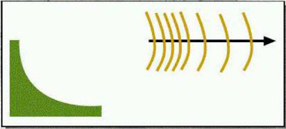
An object may seem closer than it actually is under the following conditions.
Responda
-
You are lying down
-
The light is poor or the sun in directly in front of you.
-
It is smaller than the objects around it.
-
The light is bright or the sun is shining from behind you.
Questão 27
Questão
The following is a description of which method of judging distances?
"Select an object or an area in a direct line, halfway between you and the target, and estimate the range to this midpoint. You can then double the estimation to produce the range to the target."
Responda
-
Bracketing
-
Halving
-
Key Ranges
-
Appearance Method
Questão 28
Questão
The contour interval on an Australian 1:25,000 scale topographical map is:
Responda
-
1 metre
-
10 metres
-
100 metres
-
1000 metres
Questão 29
Questão
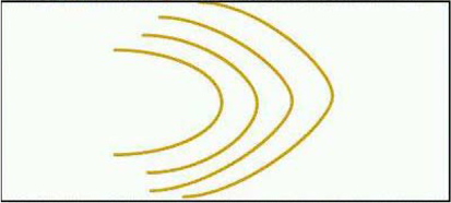
An aircraft rocking from side to side indicates:
Responda
-
Message received and understood
-
Land at the aerodrome
-
Hello
-
Thank you
Questão 30
Questão
Which of the following is NOT an specifically-authorised proword for radiotelephone procedures?
Responda
-
SAY AGAIN
-
OVER
-
NEGATIVE
-
OUT
Questão 31
Questão
If a message requires repetition, the prowords used to prefix this is:
Responda
-
I REPEAT MESSAGE
-
MESSAGE AGAIN IS
-
I SAY AGAIN
-
MESSAGE TWICE
Questão 32
Questão
Which of the following is correct in ground radiotelephone procedures:
Responda
-
OVER and OUT
-
COPY THAT
-
ROGER
-
REPEAT
Questão 33
Questão
A candidate of a group is injured and needs to be transported from his/her present location for further medical treatment. What radio report is sent?
Responda
-
NOTICAS
-
NOTEVAC
-
CASEVAC REQUEST
-
SITREP
Questão 34
Questão
A square lashing is used to:
Responda
-
used to lash two poles together at right angles across each other.
-
used to lash a square of rope together to form a hoop
-
used to tie two pieces of rope together
-
used to fix one end of a rope to a solid object such as a tree or post
Questão 35
Questão
A radio using the Ultra High Frequency (UHF) Band is limited to communication between stations that are:
Responda
-
Within a valley
-
Within line of sight
-
Not in direct sunlight
-
On high ground
Questão 36
Questão
What is the purpose of a SITREP?
Responda
-
To report location of bivouac site
-
To request assistance in transporting someone who is injured
-
To report on a navigation exercise
-
To report the current situation
Questão 37
Questão
In which of the following situations would you send a NOTICAS?
Responda
-
To report that someone is ill or injured
-
To report location
-
To report the situation
-
To request assistance in transporting someone who is injured
Questão 38
Questão
Radiotelephone procedure is a set of rules designed to provide:
Responda
-
Prowords
-
Security, accuracy and discipline
-
Security breaches
-
Brevity, clarity and security
Questão 39
Questão
What does the proword WILCO mean?
Responda
-
Message received, understood, and will be complied with
-
I have received and understood your message
-
The same as the proword ROGER
-
The same as the proword ACKNOWLEDGE
Questão 40
Responda
-
Roamers
-
Direction of Travel Arrow
-
Magnifying glass
-
Orienting Arrow
-
Degrees Scale
-
Compass Housing
-
Orienting Lines
-
Magnetic Needle
-
Base Plate
-
Scale
Questão 41
Questão
Which of the following are contained in a LOCSTAT?
Responda
-
Grid reference, halted/moving, topography description, water status
-
Callsign, grid reference, halted/moving, direction of movement
-
Grid reference, time to objective, direction of movement, ration status
-
Callsign, grid reference, time to objective, topography description
Questão 42
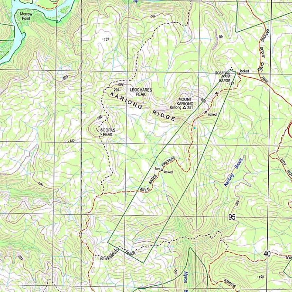
Questão
Using the 1:25,000 scale topographic map extract below, answer the following:
During a navex you have become unsure of your position, and have identified three topographic features in proximity to you on both map and ground These features are to the north, south-west and east of your current position. Based on the route you were travelling, Gosford Rifle Range is to the east of your position. Using your compass, you confirm the magnetic bearing of each of these features is:
1. 320 degrees
2. 248 degrees
3. 80 degrees
Use the resection method to determine your location. Note that the magnetic variation for this map (Gosford 9131-2-S) is currently 11.5 degrees east.
[blank_start]GR 382964[blank_end]
Image:
Map (binary/octet-stream)
Responda
-
382964
Questão 43
Questão
Using the 1:25,000 scale topographic map extract below, what feature can be found at GR :376962?
[blank_start]Scopas Peak[blank_end]
Responda
-
Scopas Peak
Questão 44
Questão
Using the 1:25,000 scale topographic map extract below, what is the distance between Spot Height 137 and Spot Height 182?
[blank_start]1400m[blank_end]
Responda
-
1400m
Questão 45
Questão
Using the 1:25,000 scale topographic map extract below, name and provide the grid reference for the highest feature on the map:
[blank_start]Mt Kariong GR 387965[blank_end]
Responda
-
Mt Kariong GR 387965
Questão 46
Questão
While moving along a bearing, a quick way for a section commander to check where the section is on a route is to:
Responda
-
Assess whether the ground covered conforms with the 'going' information that was put into the navigation data sheet.
-
Assess if the sun is located in a position as expected for the time of day.
-
Average the distance estimated to have been covered by consulting your 2IC and your next most senior section member.
-
Assess whether the signal strength of radio communications with the point of origin is strong or weak.
Questão 47
Questão
You encounter an obstacle - a swamp - on your route of march. It will be advantageous to avoid the obstacle. The correct action to take is:
Responda
-
Select an object or feature to your immediate flank that is beyond the known boundary of the obstacle. Plot a new course to this object, and from that object plot another course to another object on your original line of the march.
-
Move around the edge of the obstacle, keeping as close as possible to it, while maintaining a visual on your original line of march.
-
Maintain your original line of march - avoiding difficult terrain is not an acceptable action for a section commander to take.
-
Using evenly spaced section members, advance in line abreast around the obstacle, ensuring that you minimise the number of section members who get wet, while ensuring that you can get the majority of members around the swamp.
Questão 48
Questão
Which of the following is a common method to increase the accuracy of your navigation once you commence your march?
Responda
-
Appoint a pace counter
-
Stop periodically to draw a bearing from your position to a position on the horizon directly below the sun, maintaining a 90 degree bearing to that position
-
Maintain a key feature at your 6 o'clock position
-
Use the eastern most star of the southern cross to draw a vertical line down to the horizon to determine the bearing of south.
Questão 49
Questão
You are tasked to move between Point A and Point B. The bearing on the map between these points is 120 degrees. The magnetic variation on the map is 17 degrees EAST. In order to take a bearing on your compass to establish your line of march you should:
Responda
-
Subtract the magnetic variation from the grid bearing
-
Add the magnetic variation to the grid bearing
-
Disregard the magnetic variation as it is less than 22 degrees
-
Use the grid bearing of 120 degrees as it is the true bearing between Point A and Point B
Questão 50
Questão
The letter X made out of stones in a clearing visible from the air would indicate to an aircraft that survivors need:
Responda
-
Medical assistance
-
Have stopped at this position
-
Are moving in the direction of the horizontal axis of the X
-
Have cleared the area for a helicopter landing zone
Quer criar seus próprios Quizzes gratuitos com a GoConqr? Saiba mais.